- Cìr Mhòr
-
Cìr Mhòr 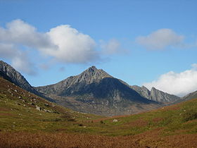
Cìr Mhòr from Glen RosaElevation 799 m (2,621 ft) Prominence 175 m (574 ft) Parent peak Caisteal Abhail Listing Marilyn, Corbett Location Location North Ayrshire,  Scotland
Range Isle of Arran OS grid NR972431 Cìr Mhòr (Scottish Gaelic, usually with definite article, A' Chìr Mhòr) is a Corbett known as the Matterhorn of Arran. Its name means the "big comb", referring its resemblance to a cockscomb. It is separated from the island's highest peak, Goat Fell by a col called The Saddle
Coordinates: 55°38′22.34″N 5°13′18.76″W / 55.6395389°N 5.2218778°W
Arran Main villages 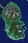
Smaller villages and settlements Mountains and hills Goat Fell · Beinn Tarsuinn · Caisteal Abhail · Cìr Mhòr · Creag Ghlas Laggan · Tighvein · Sleeping WarriorHistory Environment Arran Whitebeams · Glenashdale FallsEconomy The Arran Banner · Arran Single MaltSurrounding islands Categories:- Marilyns of Scotland
- Mountains and hills of the Scottish islands
- North Ayrshire
- Corbetts
- Isle of Arran
- North Ayrshire geography stubs


Wikimedia Foundation. 2010.