- Meall Ghaordaidh
-
Meall Ghaordaidh 
Meall Ghaordaidh (centre) from An Grianan looking over Glen Lyon, with Stronuich Reservoir (bottom left)Elevation 1,039 m (3,409 ft) Listing Munro Translation Possibly derived from gairdean (shoulder, hand or arm) (Gaelic) Location Location Stirlingshire,  Scotland
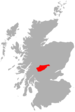
Range Grampians Topo map OS Landranger 51 OS grid NN514397 Meall Ghaordaidh is a mountain in the Southern Highlands of Scotland, approximately 10 km north-west of Killin.
The mountain can be ascended via Glen Lochay starting to the north-west of the Allt Dhùin Croisg near Duncroisk, via an eroded path leading north-west through peat bogs to the summit; alternatively, an ascent can be made from Glen Lyon starting at Stronuich via one of two spurs that lead to the summit (Creag an Tulabhain or Creag Laoghain). The summit is marked by a large circular rock windbreak, within which there is a trig point.
The name of the mountain has taken a few turns over the years. Centuries ago it was mapped as Bin-Gyroy. One-inch maps in the early 1900’s referred to it as Meall Ghaordaidh, then for some reason it changed to Meall Ghaordie in the 1920’s. The current Landranger reverts to Meall Ghaordaidh though the Munro Tables have consistently opted for Meall Ghaordie (though the Scottish Mountaineering Club guide to the Munros has it as being Meall Ghaordaidh). Ghaordaidh could mean a part of the body such as the upper arm or shoulder, possibly from the Gaelic “gairdean,” so may mean rounded hill of the shoulder, a description that could apply to many a hill. It is interesting to consider hill names and wonder what direction they were named from. It may have been the early inhabitants of Glen Lochay who named this one for, apart from its small area of summit crags, the southern slopes are broad and grassy. The old shielings on these lower slopes would support this idea. From the Glen Lyon side, however, meall is a misnomer. Three craggy spurs jut towards the glen – Creag an Tulabhain, Creag Laoghain and Creagan an t-Stuichd.
One of the less distinguished Munros, Meall Ghaordie is essentially a blunt nose that lifts itself above the rough moorland of the long, undulating ridge that stretches between the Lairig Breisleich and the Lairig nan Lunn; passes which connect Glen Lochay in the south with Glen Lyon in the north. The normal guidebook route follows the long grassy slopes from Glen Lochay to the south. An alternative route from Glen Lyon to the north is marginally more attractive, thanks to a couple of notable rocky spurs, Creag an Tulabhain and Creag Laoghain. Unfortunately, given that this mountain shall be the first climbed on the week of our caravan trip to Killin, and an evening climb to boot, we shall be doing the straightforward ascent from Glen Lochay. A long trudge of some 890 metres (2,700feet) from Duncroisk follows grassy slopes, the monotony of which is only broken by some rocky outcrops near the summit ridge. From the summit of Meall Ghaordie, a northeast ridge drops to a high bealach from where steep slopes climb to the summit of the shapely Beinn nan Oighreag. From here another ridge stretches north above the Lairig Breisleich before dwindling out above the Lochan na Lairig road (the high- level road that runs past the Ben Lawers Visitor Centre) as it descends to Bridge of Balgie in Glen Lyon.
The Route:
1. There is space for about four cars a short distance past the bridge over Allt Dhuin Croisg on the road up Glen Lochay from Killin. Begin the walk by heading back along the road towards the bridge and then turning left through a gate signed for “Access to Meall Ghaordaidh” before reaching it. This leads onto a rough track up through the fields; follow this, crossing the stile to the right when the track goes through a gate in a grass-topped stone wall.
2. The path continues uphill with the pretty little wooded ravine of the Allt Dhuin Croisg on the right. Higher up there are the remains of some old stone shielings, remnants of a bygone age. Frome these a worn path goes north-west (left) on what is, at first, the vague south-east ridge of Meall Ghaordaidh. Continue north-west on a good angle of ascent as the grassy ridge becomes more defined.
3. The ascent is mostly grassy and wet in places. Continue in the same direction as the ridge becomes marginally better defined whilst an under-mapped craggy shoulder is reached at about 750 metres – care should be expressed here in misty conditions. Beyond the climb steepens for the final push up to the stony summit where a trig point can be found at 1039 metres, encircled by a stone wind-shelter. The views are good, particularly northwest over the head of Glen Lyon and its eponymous loch.
4. If returning to Glen Lochay, the quickest route is to go back the same way. The Glen Lyon side of the mountain has a more interesting appearance as to this side Meall Ghaordaidh is buttressed by two rocky spurs, Creag Laoghain and Creag an Tulabhain. The ascent from here is a little tougher and requires more effort, usually being made via Coire Laoghain between the two spurs.
 An Stùc · Beinn Achaladair · Beinn Challuim · Beinn a' Chreachain · Beinn Dòrain · Beinn an Dòthaidh · Beinn Ghlas · Beinn Heasgarnich · Ben Lawers · Beinn Mhanach · Càrn Gorm · Càrn Mairg · Creag Mhòr · Meall Corranaich · Meall nan Aighean · Meall Buidhe · Meall a' Choire Leith · Meall Ghaordaidh · Meall Garbh (Càrn Mairg Group) · Meall Garbh (Lawers Group) · Meall Glas · Meall Greigh · Meall nan Tarmachan · Schiehallion · Sgiath Chùil · Stuchd an Lochain
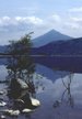
List of Munros Categories:- Munros
- Mountains and hills of the Southern Highlands


Wikimedia Foundation. 2010.