- Meall Buidhe, Glen Lyon
-
This article is about a Munro. For the other, lower, hill in the Glen Lyon area called Meall Buidhe, see Meall Buidhe (Corbett).
Meall Buidhe 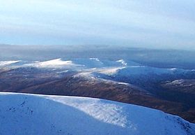
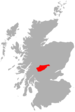
Elevation 932 m (3,058 ft) Prominence c. 236 m Parent peak Stuchd an Lochain Listing Munro, Marilyn Translation Yellow hill (Gaelic) Pronunciation Scottish Gaelic: [mjaulˠ̪ pujə] Location Location Stirling council area, Scotland Topo map OS Landranger 51 OS grid NN498499 Meall Buidhe is a Munro situated in the southern highlands of Scotland. It forms the northern side of Loch an Daimh and is often climbed in conjunction with Stuchd an Lochain. The normal route climbs north from the eastern end of the loch until easier ground is reached. The route angles east and then north once the ridge is gained. Strong walkers can continue round the loch and take in a Corbett, Sron a' Choire Chnapanich, and the aforementioned Stuchd an Lochain.
Coordinates: 56°37′01″N 4°26′57″W / 56.61681°N 4.44925°W
 An Stùc · Beinn Achaladair · Beinn Challuim · Beinn a' Chreachain · Beinn Dòrain · Beinn an Dòthaidh · Beinn Ghlas · Beinn Heasgarnich · Ben Lawers · Beinn Mhanach · Càrn Gorm · Càrn Mairg · Creag Mhòr · Meall Corranaich · Meall nan Aighean · Meall Buidhe · Meall a' Choire Leith · Meall Ghaordaidh · Meall Garbh (Càrn Mairg Group) · Meall Garbh (Lawers Group) · Meall Glas · Meall Greigh · Meall nan Tarmachan · Schiehallion · Sgiath Chùil · Stuchd an Lochain
List of Munros Categories:- Munros
- Marilyns of Scotland
- Mountains and hills of the Southern Highlands
- Mountains and hills of Stirling council area
- Stirling geography stubs


Wikimedia Foundation. 2010.