- Drummond Township, Michigan
-
"Drummond Island" redirects here. For island in Kiribati formerly known as Drummond's Island, see McKean Island.
Drummond Township, Michigan — Township — Location within the state of Michigan
 Drummond Township, Michigan
Coordinates: 46°00′N 83°40′W / 46°N 83.667°WCoordinates: 46°00′N 83°40′W / 46°N 83.667°W Country United States State Michigan County Chippewa Area – Total 249.0 sq mi (644.9 km2) – Land 129.1 sq mi (334.3 km2) – Water 119.9 sq mi (310.6 km2) Elevation 666 ft (203 m) Population (2000) – Total 992 – Density 7.7/sq mi (3.0/km2) Time zone Eastern (EST) (UTC-5) – Summer (DST) EDT (UTC-4) FIPS code 26-23080[1] GNIS feature ID 1626193[2] Website www.drummondislandchamber.com Drummond Township is a civil township of Chippewa County in the U.S. state of Michigan. The population was 992 at the 2000 census.
The township consists of Drummond Island, one of the largest islands in Lake Huron. M-134 runs through the western portion of the island. The highway connects with the mainland portion via the Drummond Island Ferry, which runs between De Tour Village and the island.
On the east side of Drummond Island, the Canada-United States border passes through the False Detour Channel. On the other side of that channel, the Canadian Cockburn Island separates Drummond from Manitoulin Island.
Drummond is an unincorporated community within the township, situated on Potagannissing Bay on the northwest side of the island at 46°01′12″N 83°43′52″W / 46.02°N 83.73111°W.[3] M-134 ends south of the community.
Contents
History
The history of Drummond Island dates back centuries, but more recent history of the past two-hundred years relates to the British occupation of the island after the War of 1812. The island was the last British outpost on American soil following the Treaty of Ghent, finally returned to American hands in 1828.[4] The island is named after Canadian Gordon Drummond.[5]
Wildlife
Drummond Island is an oasis of wildlife. Deer are a very common sight, with the occasional bear lumbering by. Other common forest mammals include raccoons, weasels, woodchucks, rabbits, squirrels, chipmunks, and mice of several varieties. Rarer sightings may include bobcats, coyotes, wolves, and the occasional moose. Wetlands host many species. Frogs inhabit small ponds, as does the northern water snake. Turtles, as slow as they are, can be slightly harder to find than snakes. Painted turtles may be found along the road as well as in ponds. There are also garter snakes and copper bellies, all non-venomous varieties. As for birds there are several species of woodpeckers, the ruby-throated hummingbird, many finch species, sparrows, black birds, crows, ravens, owls, hawks, osprey and eagles. Most of the species of fish found in the Great Lakes are present here in northern Lake Huron. There are also many species of minnows. All the lake bottom environment has been drastically affected by the introduction of the zebra mussel. The environment used to support habitat for crayfish, three leech varieties, water insects and snails.There are no ticks on Drummond Island. There are very few skunks on Drummond Island, if at all.[citation needed]
Geography
According to the United States Census Bureau, the township has a total area of 249.0 square miles (645 km2), of which, 129.1 square miles (334 km2) is land and 119.9 square miles (311 km2)(48.17%) is water. On the Island itself, it is mainly dominated by forest, with cliffs on the eastern side.
Over two thirds of the island is land owned by the State of Michigan.[citation needed]
Demographics
As of the census[1] of 2000, there were 992 people, 467 households, and 309 families residing in the township. The population density was 7.7 per square mile (3.0/km²). There were 1,476 housing units at an average density of 11.4 per square mile (4.4/km²). The racial makeup of the township was 90.83% White, 0.20% African American, 4.84% Native American, 0.10% from other races, and 4.03% from two or more races. Hispanic or Latino of any race were 0.71% of the population.
There were 467 households out of which 18.2% had children under the age of 18 living with them, 58.5% were married couples living together, 3.9% had a female householder with no husband present, and 33.8% were non-families. 29.3% of all households were made up of individuals and 10.5% had someone living alone who was 65 years of age or older. The average household size was 2.12 and the average family size was 2.59.
In the township the population was spread out with 16.9% under the age of 18, 3.9% from 18 to 24, 20.9% from 25 to 44, 35.3% from 45 to 64, and 23.0% who were 65 years of age or older. The median age was 51 years. For every 100 females there were 107.1 males. For every 100 females age 18 and over, there were 103.0 males.
The median income for a household in the township was $36,131, and the median income for a family was $39,931. Males had a median income of $35,729 versus $24,250 for females. The per capita income for the township was $21,963. About 7.6% of families and 9.0% of the population were below the poverty line, including 6.3% of those under age 18 and 7.9% of those age 65 or over.
References
- ^ a b "American FactFinder". United States Census Bureau. http://factfinder.census.gov. Retrieved 2008-01-31.
- ^ U.S. Geological Survey Geographic Names Information System: Drummond Township, Michigan
- ^ U.S. Geological Survey Geographic Names Information System: Drummond, Michigan
- ^ http://www.absolutemichigan.com/dig/michigan/michigan-history-the-first-residents-of-drummond-island/
- ^ http://www.upperpeninsulaonline.com/html/drummond_island.html
Municipalities and communities of Chippewa County, Michigan City 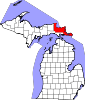
Village Charter
townshipGeneral law
townshipsUnincorporated
communitiesCategories:- Townships in Chippewa County, Michigan


Wikimedia Foundation. 2010.