- Deir al-Balah
-
This article is about a Palestinian city. For the nearby refugee camp, see Deir el-Balah camp.
Deir el-Balah Other transcription(s) – Arabic دير البلح – Also spelled Deir al-Balah (official)
Dayr al-Balah (unofficial)Location of Deir el-Balah within the Palestinian territories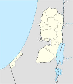
 Deir el-Balah
Coordinates: 31°25′08.38″N 34°21′05.77″E / 31.4189944°N 34.3516028°ECoordinates: 31°25′08.38″N 34°21′05.77″E / 31.4189944°N 34.3516028°E Governorate Deir al-Balah Government – Type City – Head of Municipality Ahmad Kurd Population (2006) – Jurisdiction 62,150 Deir el-Balah or Dayr al-Balah (Arabic: دير البلح) is located in the central Gaza Strip and is the capital or muhfaza (seat) of the Deir el-Balah Governorate. According to the Palestinian Central Bureau of Statistics, the city had a population of 49,751 in mid-year 2006.[1][2]
Well-known for its beaches and date palms, recent archeological excavations uncovered a cemetery dating back to the late Bronze Age filled with pottery, tombs, bronze pots and a mosaic floor. Deir al-Balah also contains a monastery built by St. Helena in 372 AD.
The city has been a frequent target of Israeli incursions, particularly since the beginning of the Second Intifada in 2001, with the stated aim of stopping Qassam rocket fire into Israel.[3][4][5] Ahmad Kurd, a Hamas member, was elected mayor in late January 2005 and of the city's council seats, 13 of 15 were won by Hamas candidates in February 2005.[6][7]
Contents
History
During the Crusader period in 1149, Deir al-Balah or Darum became a stronghold of the Templar Knights and the Knights Hospitaller from Jerusalem, led by King Baldwin III.[8] Forts were built in Deir al-Balah that were used as a base from which to attack the Fatimid forces who had withdrawn from Gaza and established independent rule in Ascalon.[8] By the end of 1170, Saladin’s army had arrived, entering Palestine through Darum, now known as Deir al-Balah. [8]
The tug-of-war between the Crusaders and various Cairo-based Muslim forces continued.[8] After the Ayyubids were overthrown by the Mamluks from within the palace walls in Cairo, Deir al-Balah came under Mamluk rule from 1250 to 1517.[8] Regular mail routes run by mounted messengers with colored sashes were introduced from Cairo to Gaza via the towns of Rafah, Wadi as-Salqa, al-Darum (Deir al-Balah), Malkas, Bayt Jibrin, Beit Hanoun, Beit Daras, Qatra, Lydda, Auja, Tira, Qatoun, Fahmah and Jenin, and from there to Damascus.[8] Roads, bridges, postal stations and khans were built to accommodate the messengers.[8] Pigeon mail service was introduced for which towers were built.[8] Produce available in this time period in Deir al-Balah included barley, wheat, grapes and grape leaves, olives, raspberries, lemons, figs, sweet melons, pomegranates and dates.[8]
Al-Aqsa Intifada
The city has been a frequent target of Israeli incursions since the Al-Aqsa Intifada in 2001, in part due to Qassam rocket-strikes.[3][4][5]
In January 2004, the Palestinian Center for Human Rights reported that the Israel Defense Forces issued "written orders to 10 Palestinian families in Deir el-Balah ordering the confiscation of their land and homes located northeast of Kfar Darom settlement. According to the owners of these properties, Israeli soldiers informed them orally when they were handed the orders that the land will be used to establish additional Israeli security facilities. The total area subject to these confiscation orders is approximately 700 dunums."[9]
The areas surrounding city has also been frequent targets of razing. On January 4, 2004, "Israeli bulldozers destroyed more than 50 dunums of land mostly cultivated with olive trees in Abu El-‘Ajen area east of Deir el-Balah city." Later on January 7, 2004, "Israeli bulldozers staged into Al-Hikr area south of Deir el-Balah city under heavy barrage of gunfire and razed 70 dunums of land cultivated with guava and orange owned by Abu Holy and Abu Reziq families."[10]
The Applied Research Institute (Jerusalem) reported that on November 2, 2004, the "house of Hassan Abu Maghseb was dynamited after the IDF planted it with heavy explosive devices in Wadi el-Salqa area to the east of Deir el-Balah, displacing all of its dwellers."[11]
Income
The working population in Deir el-Balah was 24,304 in 2005, the vast majority being paid employees. Most workers are involved in service shops and markets and trading hand-made crafts. The city has a fishing industry although it is very minor. The United States and United Kingdom have imposed economic sanctions on the Palestinian territories that has severely damaged Deir el-Balah's economy along with those of most cities in the Gaza Strip.[citation needed]
Commonwealth War Cemetery
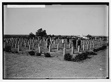 1918 photo from the Deir al-Balah Commonwealth War Cemetery
Northwest of Deir al-Balah is one of two Commonwealth War Cemeteries in Gaza. Commonly referred to as the British War Cemetery of Deir al-Balah. The CWGCs name for it is Deir El Belah War Cemetery (note the alternative transcription of دير اللبلح).
Mayors
- Ahmad Kurd
- Sami Abu Salim
See also
Notes
- ^ Projected Mid -Year Population for Deir al Balah Governorate by Locality 2004- 2006 Palestinian Central Bureau of Statistics
- ^ Profile: Gaza Strip, BBC News Online, 27 June 2006, accessed 8 May 2007.
- ^ a b US calls on Israel to withdraw, BBC News Online, 28 August 2001, accessed 8 May 2007.
- ^ a b Fresh incursion in Gaza, BBC News Online, 14 February 2002, accessed 8 May 2007.
- ^ a b A new role for Hamas: Running Gaza's cities, The New York Times, May 27, 2005, accessed 9 May 2007.
- ^ "Hamas Dominates Local Vote in Gaza". The Washington Post. 29 January 2005. http://www.washingtonpost.com/wp-dyn/articles/A44058-2005Jan28.html. Retrieved 1 May 2010.
- ^ Scott Wilson (2005-09-05). "Israeli Pullout Creates Political Opportunity: Shift of Gaza Land and Assets to Palestinians Sharpens Hamas-Fatah Rivalry". Washington Post. p. A25. http://www.washingtonpost.com/wp-dyn/content/article/2005/09/04/AR2005090401229_pf.html. Retrieved 2007-05-21.
- ^ a b c d e f g h i Mariam Shahin (2005). Palestine: A Guide. Interlink Books. pp. 421 – 423. ISBN 156656557X.
- ^ Israeli Occupying Forces Demolish 25 Houses in Rafah and Issue Land Confiscation Orders in Deir El-Balah, Palestinian Center for Human Rights, January 2004
- ^ [1], Applied Research Institute, Volume 66, January 2004
- ^ [2], Applied Research Institute, Volume 76, November 2004
External links and references
- Gaza Refugee Camp Profiles, UNWRA, 31 March 2006.
- Laborers in Deir Al Balah Governorate
- Projected Mid -Year Population for Deir Al- Balah Governorate by Locality 2004- 2006, Palestinian Central Bureau of Statistics.
- Sixty Israeli tanks break into Deir al-Balah, two Palestinians shot Arabic News.com
- Map of the Deir-al Balah Governorate
- Article on Washington Post
- CWGC's description of the War Cemetery
Cities Deir al-Balah
Municipalities az-ZawaydaVillage councils al-Musaddar · Wadi as-SalqaRefugee camps  Cities in Palestinian National Authority areas
West Bank Gaza Strip Categories:- Deir al-Balah Governorate
- Cities in the Gaza Strip


Wikimedia Foundation. 2010.