- Centerville, Iowa
-
Centerville, Iowa — City — 
SealLocation of Centerville, Iowa
Coordinates: 40°43′47″N 92°52′19″W / 40.729836°N 92.872012°WCoordinates: 40°43′47″N 92°52′19″W / 40.729836°N 92.872012°W Country USA State  Iowa
IowaCounty Appanoose Area – Total 4.6 sq mi (11.8 km2) – Land 4.5 sq mi (11.7 km2) – Water 0.0 sq mi (0.1 km2) Elevation 1,007 ft (307 m) Population (2010)[1] – Total 5,924 – Density 1,287.8/sq mi (497.2/km2) Time zone Central (CST) (UTC-6) – Summer (DST) CDT (UTC-5) ZIP code 52544 Area code(s) 641 FIPS code 19-12315 GNIS feature ID 0455310 Centerville is a city in and the county seat of Appanoose County, Iowa, United States. [2] The population was 5,528 in the 2010 census, a decline from 5,924 in the 2000 census.[1][3] After the turn of the 20th century Centerville had a booming coal mining industry that attracted many European immigrants. The city today remains the home of many Swedish-Americans, Italian-Americans, Croatian-Americans, Albanian-Americans and others descended from immigrants who worked in the mines.
Contents
History
Founded in 1846 by Jonathon Stratton under the name of "Chaldea," the city was planned around a unique two-block long city square. The name was later changed to Senterville, named after William Tandy Senter, a prominent Tennessee politician. When incorporation papers were filed in 1855, someone mistook the name for a misspelling and corrected it to Centerville.[4]
A mining town
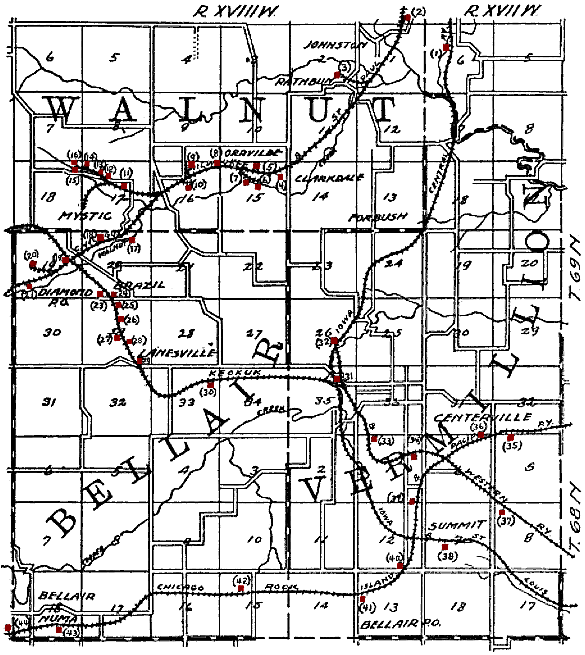
 Map of the Centerville area from 1908, showing the railroads and shipping coal mines (shown in red) of the region. Centerville is in the lower right quadrant. Smaller mines that did not ship by rail are not shown.
The first coal mine in Centerville was opened in 1868, with its mine shaft about one-half mile from the Chicago, Burlington and Quincy Railroad depot. Horse-power was used to raise coal from the mines until 1872, when the Watson Coal Company opened a mine equipped with a steam hoist. The Centerville Block Coal Company, organized in 1894, consolidated the operation of numerous mines in the region to become the dominant mining company. In 1914, Centerville Block Coal produced over 100,000 tons of coal, ranking among the top 24 coal producers in the state. Centerville Block's largest competitor, formed around the same time, was the Scandinavian Coal Company, organized by a group of Swedish immigrants.[5][6] By 1938, coal production in the Centerville region was 600,000 tons per year.[7] The mines were in the Mystic coal bed, 125 feet below ground in Centerville but exposed at the surface in Mystic, 5 miles to the northwest.[8]
 The upper works of the Relay Mine No. 3, circa 1908.
Centerville Block Coal's Relay Mine Number 3 was located on the west side of town (Number 31 on the map). By 1908, the coal face was a mile from the base of the shaft. Mules were used to haul trains of loaded coal tubs to the main haulage way, where they were hauled by a continuous loop of cable the last half mile to the shaft. The coal seam here was about 3 feet thick, and the shaft was 107 feet deep. A centrifugal blower 12 feet in diameter provided ventilation, and compressed air was used to power mining machinery.[9][10]
Local Assembly 1020 of the Knights of Labor was based in Centerville and had a membership of 150 in 1884.[11] On April 1, 1885, 325 miners in town went on strike, protesting a 20% drop in wages reflecting a decrease in the demand for coal during the summer months.[12] Later, the United Mine Workers of America had a very strong presence in Centerville. In 1912, UMWA Local 553 in Centerville had 1194 members, making it the second largest UMWA local in the country.[13] The largest UMWA local was in Buxton, Iowa.
In 1910, the Scandinavian Coal Company drilled a 550 foot exploratory hole in Centerville, discovering a deposit of gypsum and anhydrite 10 feet thick near the bottom. The Centerville Gypsum Company was formed to exploit this deposit, and between 1912 and 1913, the company bored a shaft down to the gypsum. Water problems delayed the opening of the mine until 1917, and commercial production began in 1919.[14] The mine was closed in the early 1930s.[15]
The Sunshine mine, about 3 miles west of Centerville (number 30 on the map), was very small in 1908, with just a horse-powered hoist at the pit head.[10] By the 1930s, this was a large mine with an attached mining camp and a mountain of mine waste 500 feet long.[16] The Sunshine Mine Drive-In is a theater on the former mine site that opened in 2005.[17]
The post-coal era
Centerville experienced its peak population in the early 1900s as the popularity of coal peaked. After that point, as usage dwindled, the coal industry that had been the community's life blood collapsed. In the 1950s and 1960s a civic movement to promote new industries began. This effort culminated in the building of Rathbun Dam, near the city of Rathbun, Iowa, forming Rathbun Lake, known as "Iowa's Ocean", that was dedicated on July 31, 1971 by President Richard M. Nixon.
Today the city is supported by several small industrial plants, mostly in the area of plastic products. In June 2006 the Centerville Daily Iowegian reported that the city's largest employer, a Rubbermaid plant, that opened in Centerville in 1985, would shut down in September 2006 displacing 500 workers. In 2007, the former Rubbermaid building was purchased by Lee Container Corp. of Homerville, Georgia, and is planned to be re-opened in 2008. Lee Container is a manufacturer of H.D.P.E. blow molded containers for crop protection-, lubricant-, pet care-, beverage-, specialty- and household products. The city (and county) is also served by several other manufacturing operations, including Curwood, a Bemis Company, a major supplier of flexible packaging and pressure sensitive materials used by leading food, consumer products, manufacturing, and other companies worldwide. The Barker Company, of Keosauqua, Iowa that manufactures many lines of refrigerated, non-refrigerated and hot display cases for the supermarket, convenience store and food service industries located a manufacturing plant in Centerville in 1998.
As county seat, Centerville had a thriving retail sector, serving people from smaller communities and farms in the area as well as local residents. Many shops were located around the Courthouse Square Historic District, which has hundreds of parking spaces between the shops' sidewalks and the courthouse lawn—in effect, six-lane wide streeting around the Appanoose County Courthouse provides four lanes of public parking. In the latter decades of the 20th century, Centerville, like many other small American communities, experienced a change in its retail economy as many long-established locally owned shops closed, due in large part to loss of business to large nationally owned retailers. Many of the former stores have been replaced by specialty gift shops and antique stores, catering to tourists as well as locals.
In 1999, the Lake Center Mall was destroyed by an act of arson. The entire site sat unoccupied until a cineplex and a Pizza Ranch were built there in the early 2000s.
In 1984, the Appanoose County Community Railroad was formed out of discarded pieces of the Wabash and Rock Island lines to maintain a rail link to the outside world. Forming the railroad helped to bring Rubbermaid to the city.
Since the 1990s, Centerville has focused on quality-of-life issues in an attempt to attract and keep young families in the area. A new emphasis on the arts, culture and local history has emerged, culminating in the Townscape project to beautify the Courthouse Square Historic District.
Geography
According to the United States Census Bureau, Centerville has a total area of 4.6 square miles (12 km2), of which, 4.5 square miles (12 km2) of it is land and 0.04 square miles (0.10 km2) of it (0.88%) is water.
Demographics
Centerville Historical Population Year Pop. ±% 1860 820 — 1870 1,037 +26.5% 1880 2,475 +138.7% 1890 3,668 +48.2% 1900 5,256 +43.3% 1910 6,936 +32.0% 1920 8,486 +22.3% 1930 8,147 −4.0% 1940 8,413 +3.3% 1950 7,625 −9.4% 1960 6,629 −13.1% 1970 6,531 −1.5% 1980 6,558 +0.4% 1990 5,936 −9.5% 2000 5,924 −0.2% 2010 5,528 −6.7% Iowa Data Center[3] 2010 census
The 2010 census recorded a population of 5,528 in the city, with a population density of 1,228/sq mi (474/km2). There were 2,838 housing units, of which 2,491 were occupied.[1]
2000 census
As of the census[18] of 2000, there were 5,924 people, 2,583 households, and 1,516 families residing in the city. The population density was 1,310.5 people per square mile (506.0/km²). There were 2,935 housing units at an average density of 649.3 per square mile (250.7/km²). The racial makeup of the city was 97.35% White, 0.81% African American, 0.14% Native American, 0.37% Asian, 0.44% from other races, and 0.89% from two or more races. Hispanic or Latino of any race were 1.52% of the population.
There were 2,583 households out of which 27.3% had children under the age of 18 living with them, 43.4% were married couples living together, 11.9% had a female householder with no husband present, and 41.3% were non-families. 36.3% of all households were made up of individuals and 18.7% had someone living alone who was 65 years of age or older. The average household size was 2.21 and the average family size was 2.88.
In the city the population was spread out with 23.3% under the age of 18, 8.9% from 18 to 24, 25.2% from 25 to 44, 19.9% from 45 to 64, and 22.8% who were 65 years of age or older. The median age was 39 years. For every 100 females there were 82.4 males. For every 100 females age 18 and over, there were 78.0 males.
The median income for a household in the city was $25,498, and the median income for a family was $36,855. Males had a median income of $28,333 versus $21,207 for females. The per capita income for the city was $13,574. About 11.3% of families and 18.2% of the population were below the poverty line, including 18.2% of those under age 18 and 14.7% of those age 65 or over.
Events
Pancake Day
Since 1949 the city has conducted an annual Pancake Day festival. For the first five years the celebration was held the first Thursday in October until 1954 when it was moved to the last Thursday in September. In 1965 the celebration was moved to the last Saturday in September. Pancake Day is a time for local businesses and organizations to cook up pancakes which they provide for free to their customers to show thanks for their continued patronage. The event that is held in the Courthouse Square Historic District features a morning kiddie parade, a larger afternoon parade with a unique double loop parade route, a beauty queen contest and free entertainment.
Pancake Day has been attended by many well-known celebrities including Tennessee Senator Estes Kefauver; J. C. Penney; Philip W. Pillsbury; former Governor of New York, W. Averell Harriman; Muriel Humphrey; Rocky Marciano; and Centerville Native Simon Estes. Entertainers have included Thomas Ian Nicholas, Barbara Mandrell, and Minnie Pearl.
Croatian Fest
Croatian Fest has been held in Centerville on the last Saturday in July since 1987 to celebrate the areas Croatian Heritage. It is celebrated with colorful ethnic costumes, music, dancing and entertainment, as well as home-cooked ethnic food. The event includes an afternoon Polka Mass celebrated at Saint Mary’s Catholic Church.
Croatian Fest was held in the Courthouse Square Historic District through 2004 and is now held at the Knights of Columbus Hall.
Croatian Fest was not held in 2008. It is unknown at this time if it will be held in future years.
Education
The school district serving Centerville is the K-12 Centerville Community School District. It consists of Centerville High School, Howar Junior High, Lakeview Middle School and Central, Lincoln and Garfield Grade Schools all located in Centerville and the Cincinnati Grade School and Mystic Grade School located in the communities of Cincinnati and Mystic.
The mascot name for Centerville High School is the "Big Reds" and "Redettes" with the school colors being Scarlet and Black.
The first Centerville High School graduate—and the one and only graduate from the Class of 1876—was Jennie Drake, the daughter of former Governor of Iowa Francis M. Drake. The first African-American graduate was Joseph Edwin Herriford, a graduate from the Class of 1885.
Centerville is the home of the Centerville Campus of Indian Hills Community College, a two year community college, that was established in 1930 as Centerville Junior College, later known as Centerville Community College. It later merged with the area community college of Indian Hills Community College, which has its main campus located in Ottumwa, Iowa.
Media
Newspapers
Ad Express Centerville, Daily Iowegian
Websites
The Pitch Sports Show (Delivers news, schedules, scores, and more on Centerville sports. The official site of a weekly sports show on KCOG called "The Pitch.") InCentervilleIowa.com (InCentervilleIowa.com (ICI) is a video blog dedicated to the ongoing promotion of Centerville, Iowa. Events, Sports, Live Music, Businesses, Non Profits and more.)
Radio Stations
-
- AM Radio
KCOG 1400 The True Oldies Channel
-
- FM Radio
KMGO 98.7 Iowa's # 1 Country KCOG 99.7
Film
The independent 2005 movie Iowa, starring Matt Farnsworth and Rosanna Arquette, was filmed in Centerville.[19]
Music
One of the songs on the album 154 by British band Wire is called "Map Ref. 41°N 93°W", which is a reference to Centerville, Iowa.
Notable people
- John Bushemi, photographer
- Francis M. Drake, Governor of Iowa
- Simon Estes, bass-baritone opera singer
- Claude Payton, actor
- Claude R. Porter, government official and politician
- John K. Valentine, 29th Lieutenant Governor of Iowa
- Himie Voxman, clarinetist
- Madison M. Walden, Lieutenant Governor of Iowa
References
- ^ a b c "Population & Housing Occupancy Status 2010". United States Census Bureau American FactFinder. http://factfinder2.census.gov/faces/tableservices/jsf/pages/productview.xhtml?pid=DEC_10_PL_GCTPL2.ST13&prodType=table. Retrieved April 28, 2011.
- ^ "Find a County". National Association of Counties. http://www.naco.org/Counties/Pages/FindACounty.aspx. Retrieved 2011-06-07.
- ^ a b "Data from the 2010 Census". State Data Center of Iowa. http://www.iowadatacenter.org/archive/2011/02/feb10. Retrieved April 28, 2011.
- ^ Tom Savage, A Dictionary of Iowa Place Names, University of Iowa Press, 2007; page 52.
- ^ James H. Lees, History of Coal Mining in Iowa, Chapter III of Annual Report, 1908, Iowa Geological Survey, 1909, pages 536–537
- ^ Frederick E. Saward, The Coal Trade, 1915, page 65.
- ^ WPA Federal Writers Project, IOWA Guide to the Hawkeye State, State Historical Society of Iowa and Hastings House, 1938 and 1949, page 540
- ^ Frank A. Wilder, James H. Lees and A. W. Hixton, Fuel Value of Iowa Coals with Analyses of Iowa Coals, Chapter II of Annual Report, 1908, Iowa Geological Survey, 1909, pages 408
- ^ F. M. Fultz, Out of Door Studies in Geography, I, The Making of the Surface and Soils of the Upper Mississippi Region, The Public School Publishing Co., Bloomington Ill., 1916, Copyright 1908; see chapter V, An Iowa Coal Mine, page 97.
- ^ a b Henry Hinds, The Coal Deposits of Iowa, Annual Report, 1908, Iowa Geological Survey, 1909, page 277.
- ^ Part III, Labor Organizations: Knights of Labor, First Biennial Report of the Bureau of Labor Statistics for the State of Iowa, Geo. E. Roberts, Des Moines, 1885; page 55.
- ^ Part VIII, Strikes and Arbitration: Strike at Centerville, First Biennial Report of the Bureau of Labor Statistics for the State of Iowa, Geo. E. Roberts, Des Moines, 1885; page 158.
- ^ Tally Sheet, Proceedings of the 23rd Annual Convention of the United Mine Workers of America Jan. 16 – Feb. 2, 1912, Indianapolis; Volume 2, page 76A.
- ^ George F. Kay, Gypsum at Centerville, Gypsum Deposits of the United States, United States Geologic Survey Bulletin 697, 1920, pages 107–109.
- ^ Robert M. McKay, Gypsum Resources of Iowa, Iowa Geological Survey, adapted from Iowa Geology, 1985, No. 10.
- ^ 1930's Aerial Photos taken by the USDA on the Iowa Geographic Map Server.
- ^ http://www.drive-ins.com/theater/iatsuns
- ^ "American FactFinder". United States Census Bureau. http://factfinder.census.gov. Retrieved 2008-01-31.
- ^ Iowa (2005) at the Internet Movie Database
External links
- Centerville Tourism Website
- City-Data Comprehensive Statistical Data and more about Centerville
Municipalities and communities of Appanoose County, Iowa County seat: CentervilleCities Centerville | Cincinnati | Exline | Moravia | Moulton | Mystic | Numa | Plano | Rathbun | Udell | Unionville

Townships Categories:- Populated places in Appanoose County, Iowa
- Cities in Iowa
- County seats in Iowa
- Populated places established in 1846
-


Wikimedia Foundation. 2010.