- Numa, Iowa
-
Numa, Iowa — City — Location of Numa, Iowa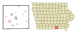
Coordinates: 40°41′8″N 92°58′43″W / 40.68556°N 92.97861°WCoordinates: 40°41′8″N 92°58′43″W / 40.68556°N 92.97861°W Country USA State  Iowa
IowaCounty Appanoose Incorporated November 9, 1909[1] Area – Total 0.4 sq mi (1.1 km2) – Land 0.4 sq mi (1.1 km2) – Water 0.0 sq mi (0.0 km2) Elevation 1,027 ft (313 m) Population (2010)[2] – Total 92 – Density 230/sq mi (88.8/km2) Time zone Central (CST) (UTC-6) – Summer (DST) CDT (UTC-5) ZIP code 52544 Area code(s) 641 FIPS code 19-57945 GNIS feature ID 0459679 Numa is a city in Appanoose County, Iowa, United States. The population was 82 in the 2010 census, a decline from 109 in the 2000 census.[2]
Contents
Geography
Numa's longitude and latitude coordinates
in decimal form are 40.685566, −92.978596. [3]According to the United States Census Bureau, the city has a total area of 0.4 square miles (1.0 km2), all of it land.
History
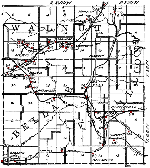
 Map of the Numa area from 1908, showing the railroads and shipping coal mines (in red) of the region. Numa is in the lower left corner. Smaller mines that did not ship by rail are not shown.
In 1907, fire destroyed the surface equipment of the Numa Block mine, at the time, the most productive mine in the county. The Numa Block shaft was 150 feet (46 m) deep, giving access to a 30-inch (760 mm) coal seam. The Numa Block Coal Company also owned mines in Seymour, Iowa (about 8 miles (13 km) to the west).[4] In 1912, Local 875 of the United Mine Workers, based in Numa, had 392 members.[5]
The original Numa Block mine was closed in 1915, after having undermined 240 acres (0.97 km2). In 1911, the Numa Block Coal Company started a new mine, about a mile east of Numa. When fully developed, this mine employed 155 men, hoisting 300 tons of coal daily to ship 175 carloads of coal monthly. A new company town, Martinstown, was platted around this mine in 1913. The 40 or so houses in Martinstown were frequently known as Shantytown. The mine closed in 1937, after undermining 96 acres (390,000 m2). Aside from the blackened remains of the Martinstown slag pile, little remains of this mine today.[6] In 1914, the Numa Block Coal Company produced over 100,000 tons of coal, ranking among the top 24 coal producers in the state.[7]
Demographics
Numa
Historical PopulationsCensus Pop. %± 1880 122 — 1890 125 2.5% 1910 659 — 1920 602 −8.6% 1930 399 −33.7% 1940 322 −19.3% 1950 248 −23.0% 1960 202 −18.5% 1970 165 −18.3% 1980 205 24.2% 1990 151 −26.3% 2000 109 −27.8% 2010 92 −15.6% Iowa Data Center[2] As of the census[8] of 2000, there were 109 people, 48 households, and 31 families residing in the city. The population density was 245.7 people per square mile (95.6/km²). There were 66 housing units at an average density of 148.8 per square mile (57.9/km²). The racial makeup of the city was 99.08% White, and 0.92% from two or more races. Hispanic or Latino of any race were 3.67% of the population.
There were 48 households out of which 25.0% had children under the age of 18 living with them, 58.3% were married couples living together, 4.2% had a female householder with no husband present, and 35.4% were non-families. 29.2% of all households were made up of individuals and 14.6% had someone living alone who was 65 years of age or older. The average household size was 2.27 and the average family size was 2.81.
In the city the population was spread out with 20.2% under the age of 18, 6.4% from 18 to 24, 33.9% from 25 to 44, 24.8% from 45 to 64, and 14.7% who were 65 years of age or older. The median age was 38 years. For every 100 females there were 113.7 males. For every 100 females age 18 and over, there were 117.5 males.
The median income for a household in the city was $26,625, and the median income for a family was $27,344. Males had a median income of $21,000 versus $16,250 for females. The per capita income for the city was $15,694. There were 8.1% of families and 10.7% of the population living below the poverty line, including 50.0% of under eighteens and 15.4% of those over 64.
References
- ^ "Numa, Iowa". City-Data. http://www.city-data.com/city/Numa-Iowa.html. Retrieved June 2, 2011.
- ^ a b c "Data from the 2010 Census". State Data Center of Iowa. http://www.iowadatacenter.org/archive/2011/02/feb10. Retrieved June 2, 2011.
- ^ "US Gazetteer files: 2010, 2000, and 1990". United States Census Bureau. 2011-02-12. http://www.census.gov/geo/www/gazetteer/gazette.html. Retrieved 2011-04-23.
- ^ Henry Hinds, The Coal Deposits of Iowa, Annual Report, 1908, Iowa Geological Survey, 1909, pages 260, 280.
- ^ Tally Sheet, Proceedings of the 23rd Annual Convention of the United Mine Workers of America Jan. 16 – Feb. 2, 1912, Indianapolis; Volume 2, page 182A.
- ^ Bill Heusinkveld, "The Numa Coal Co. in Martinstown, The Daily Iowegian, Oct. 19, 2006.
- ^ Frederick E. Saward, The Coal Trade, 1915, page 65.
- ^ "American FactFinder". United States Census Bureau. http://factfinder.census.gov. Retrieved 2008-01-31.
External links
- City-Data Comprehensive Statistical Data and more about Numa
Municipalities and communities of Appanoose County, Iowa Cities Centerville | Cincinnati | Exline | Moravia | Moulton | Mystic | Numa | Plano | Rathbun | Udell | Unionville

Townships Categories:- Populated places in Appanoose County, Iowa
- Cities in Iowa
- Company towns in Iowa

Wikimedia Foundation. 2010.