- Monti, Iowa
-
Monti, Iowa — Unincorporated community — St. Patrick's Catholic Church of Monti was built in 1870 and operated until 2005.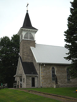 Location within the state of Iowa
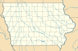
 Monti, Iowa
Coordinates: 42°22′37″N 91°38′15″W / 42.37694°N 91.6375°WCoordinates: 42°22′37″N 91°38′15″W / 42.37694°N 91.6375°W Country  United States
State  Iowa
IowaCounty Buchanan Government – Type Unincorporated Time zone Central (CST) (UTC-6) – Summer (DST) CDT (UTC-5) Area code(s) 319 Website Official website Monti is a tiny unincorporated community located in the southeast corner of Buchanan County, Iowa, United States. Founded in the 1880s and platted in 1905, the community lies on the west bank of Buffalo Creek 6 miles (10 km) east of Quasqueton and 8 miles (13 km) west of Ryan.
The railroad brought several years of prosperity to the town, but the settlement declined after World War II. Over the years, the closure of the railroad depot, bank, stores, post office, schools, and church left Monti as the site of four houses, a closed church, a cemetery, and the Monti Community Center.
Contents
Geography
Monti is located in the northern part of Newton Township, the southeasternmost of Buchanan County's townships. The village lies along County Road W-45, where that road meets with Washington Avenue, an unpaved and unimproved gravel road.
History
The town traces its roots to the late 19th century, when large numbers of Irish immigrants flocked to the state in search of new lives in the New World. The town's Catholic roots can be traced back to the first Irish settlers of Iowa.[1] A large church, St Patrick's Catholic Church of Monti, built in 1870, actually predates the town's existence. A town post office was built in either 1882 or 1885.[2]
 Warner and Foote's 1886 map of Newton Township shows Monti. The plat map shows six houses, two schools, the Catholic church, and the post office/store.
Postal service was discontinued in 1902, with the introduction of Rural Free Delivery; mail was routed through nearby Masonville.[3]
The nearby villages of Newtonville and Kiene were also located in Newton Township. In 1905, the Chicago, Anamosa and Northern Railway was built through Monti and Kiene [1]. The railroad sparked renewed interest in Monti, and a number of new buildings were constructed in 1905. The townsite was platted that year, and St. Patrick's Church registered 400 members.[4]
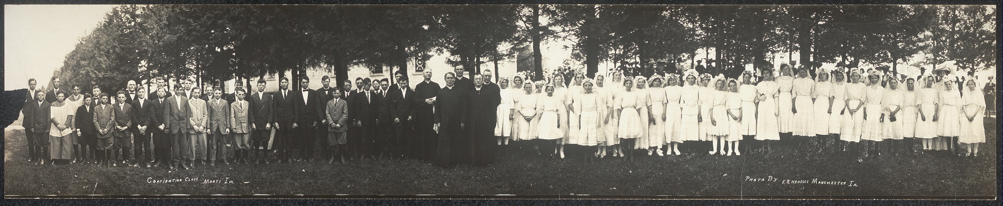
Monti was a sizeable community in 1913 when E.R. Hensley took a panoramic photograph of the 70 students in St Patrick's confirmation class [2]. However, years of rural migration gradually shrank the area's population, emptying Monti and its nearby sister communities; the town's population began to dwindle. The CAN Railway was sold for scrap after World War I. The remains of the railroad grade can still be seen today at the north edge of the hamlet.
 This is a panoramic photo of the 1913 confirmation class at St. Patrick's Catholic Church in Monti.
During the early-to-mid-20th Century, Monti attracted some attention from the Ornithology community. Noted ornithologist Fred J. Pierce reported that a large tract of timber 1 mile (2 km) "southeast of the village of Monti, in the southeastern corner of the county" was a particularly good area for birdwatching. In a 1930 paper, Pierce noted the unusual (for the area) birds he had spotted between 1923 and 1928. Among these were one specimen each of the Ruffed Grouse (1923), Cerulean Warbler (1927), and in 1928 a Yellow-bellied Flycatcher and a Connecticut Warbler.[5] As late as 1945, the Monti woods were home to at least 62 species of bird; the area was used as one of fourteen birding stations in the state. The woods contained the largest confirmed populations of Gray-cheeked Thrushes, Bobolinks, Eastern Vesper Sparrows, Eastern Field Sparrows, and Ruby-crowned Kinglets in the state during the Spring of 1945.[6] (These same woods were the scene of a gruesome hanging of an unidentified man in July 1900).[7]
In 1966, the Monti Consolidated School District was disbanded. The northern portions of the district went to East Buchanan Community School District, while the southern areas were ceded to North Linn Community School District.[8]
In 1998, RAGBRAI, a massive cross-state bicycle ride across the state, passed through the hamlet.[9]
Monti today
 Monti Community Center
Today there are fewer than two dozen residents in this dwindling farm community. Because Monti was never incorporated, population figures were never compiled. Although population figures for Monti do not exist, 423 persons live in Newton Township, the 36 square miles (93 km2) around Monti, according to the 2000 Census.[10] In 2005, St Patrick's Catholic Church, which had operated for 135 years, closed its doors. The parish was open from 1870 until July 2005.[11]
Though the town is very small, it has a community center (formed from the former church rectory).[12][13] The Monti Festival is held in June.[14] An unusual railroad flatcar bridge, constructed from two decommissioned flatcars, was built at the eastern edge of Monti in 2007. The 89 ft (27 m) long 17 ft (5.2 m) wide bridge spans Buffalo Creek on Yale Avenue, a gravel road, one mile (2 km) southeast of the community.[15] Monti students (when there are any) may attend schools in the East Buchanan Community School District.[16]
Monti is not found on most maps and can be difficult to locate. The town of Monticello, 20 miles (30 km) east, also causes some confusion. Monti appears on the official State Map of Iowa. Visitors to Monti may locate the community by heading east from Quasqueton on D-47, then turning right (south) on county road W-45, and following that road south then east to a cluster of six houses approximately 10 miles (20 km) southeast of Quasqueton. These houses mark the nucleus of the community. The large Catholic church is the most visible landmark.
Parks and recreation
There are two wildlife areas near Monti. Buffalo Creek Wildlife Area, one mile (2 km) northwest of the community, is a 52-acre (210,000 m2) park established in 1969. Hunting and fishing are allowed with permits. 3 miles (5 km) southeast of Monti is the 158-acre (0.64 km2) Newton Township Natural Area. Canoeing, fishing, and hunting are permitted at the park, which was established in 1998.[17]
Footnotes
- ^ Irish Settlers in Iowa
- ^ PostalHistory.com
- ^ "Rural service increased, many new rural mail routes to be established". Waterloo Daily Reporter (Waterloo, IA): pp. 3. 1902-04-24.
- ^ Heath, G.B. (1905-05-26). "Afoot with a camera". Waterloo Daily Courier (Waterloo, IA): pp. 3.
- ^ Pierce, Fred J. (1930). "Birds of Buchanan County, Iowa". The Wilson Bulletin 42:4, p. 253-285.
- ^ Jones, Myrle; Jones, Margaret (1945). "The Third Annual Iowa Spring Bird Census". Iowa Bird Life (Winthrop, Iowa: Iowa Ornithologist's Union) 15 (3): 42–49. http://library.iowabirds.org/issues/ibl-1945-3.pdf. Retrieved 2008-01-21.
- ^ "Hanging in the woods, body of unknown man found near Cedar Rapids". Waterloo Daily Courier (Waterloo, IA): pp. 1. 1900-07-26.
- ^ "School district plans anniversary open house". Waterloo Courier: pp. A7. 1986-05-21
- ^ Ragbrai - Cedar Falls to Monticello
- ^ Buchanan County, Iowa Census Subdivisions. Census 2000.
- ^ KWWL news site
- ^ East Buchanan Community School District
- ^ Monti Community Center
- ^ "Monti Community Center:Upcoming events"
- ^ "Field Testing of Railroad Flatcar Bridges Volume II: Multiple Spans" (2007) Bridge Engineering Center, Iowa Department of Transportation
- ^ East Buchanan Community School District
- ^ Buchanan County Conservation Report, 2004-2005 Last accessed 2008-01-26.
Further reading
Loewenberg, Ina (2004). The View from 70: Women's Recollections and Reflections. Gray Pearl Press. p. 110. ISBN 0974588105.
External links

Winthrop Masonville Quasqueton 
Ryan  Monti
Monti 

Troy Mills Coggon Municipalities and communities of Buchanan County, Iowa Cities 
Townships Unincorporated
communitiesBryantsburg | Doris | Littleton | Monti | Otterville | Shady Grove
Footnotes ‡This populated place also has portions in an adjacent county or counties
Categories:- Populated places in Buchanan County, Iowa
- Unincorporated communities in Iowa


Wikimedia Foundation. 2010.