- Newton Township, Buchanan County, Iowa
-
Newton Township, Buchanan County — Township — 
Coordinates: 42°19′51″N 091°39′14″W / 42.33083°N 91.65389°WCoordinates: 42°19′51″N 091°39′14″W / 42.33083°N 91.65389°W Country  United States
State  Iowa
IowaCounty Buchanan Area - Total 36.33 sq mi (94.09 km2) - Land 36.26 sq mi (93.92 km2) - Water 0.06 sq mi (0.17 km2) Elevation[1] 935 ft (285 m) Population (2000) - Total 423 - Density 11.7/sq mi (4.5/km2) FIPS code 19-93096[2] GNIS feature ID 0468437 Newton Township is one of sixteen townships in Buchanan County, Iowa, USA. As of the 2000 census, its population was 423.
Contents
Geography
Newton Township covers an area of 36.33 square miles (94.1 km2) and contains no incorporated settlements. The unincorporated community of Monti is in the northern portion of the township. Other settlements in the township from the late 19th and early 20th centuries are abandoned. According to the USGS, Newton Township contains three cemeteries: Circle Grove, Saint Patrick's and Upper Spring Grove. Only Saint Patrick's of Monti is maintained.
History
The first permanent white settler in Newton Township was a Joseph Austin, who built a cabin "by a spring at the edge of some timber in the township" sometime before or during 1847. The first election was held in the southern part of the township in August 1854. Many early settlers of the area were from Ireland.[3]
Two cemeteries were established in the 1850s, one in the northern and one in the southern part of the township. A Catholic church and rectory were constructed adjoining the northern cemetery in 1870.[3] Newtonville was established in 1873, when a post office was built near the center of the township,[3] at 42.347°N 91.675°W (Sections 16 and 17, see map on right).[4] In 1875, the State Atlas of Iowa showed two churches, seven schools, and 19 houses in the township. Just 11 years later, in 1886, Warner and Foote's map of Newton Township showed 137 houses, ten schools, three churches, and two post offices in the township.
 Newton Township in 1875. The township had seven schools and two churches.
 Newton Township in 1904. Newtonville is displayed prominently in the center of the township. There were two schools, a creamery, and a church in Newtonville. This church was moved three miles north in 1914. Atlantic and Monti are not labeled on this map, but are in the northern and southern portions of the township, respectively. Kiene is not shown on this map because it wasn't founded until 1911.
Many other small settlements sprang up, including Erin, Atlantic, and Monti. None of these communities ever incorporated. Atlantic was located at 42.311°N 91.685°W (Sections 28 and 33), and Erin at 42.369°N 91.600°W (Section 1).[4] Monti was founded in 1885, on Buffalo Creek in the northern part of the township, at the location of the Catholic church (Sections 2 and 3).[5] With the introduction of Rural Free Delivery in 1902, both the Newtonville and Monti post offices closed.
In 1911, the village of Kiene was founded 1.5 miles west of Monti at 42.384°N 91.661°W (Section 4), the result of a planned railway through the area. Kiene was named after Henry Kiene or Peter Kiene, presidents of the proposed rail line, who planned a rail route west from Dubuque toward Independence in 1903.[6][7] The Chicago, Anamosa and Northern (CAN) Railway was built through Newton Township in 1912 and passed through both Kiene and Monti. Monti soon became a small but bustling community, with stores, a blacksmith shop, a bank, and a flag station.[8] The old Newtonville Congregational Church was moved to Kiene in June 1914, and a new church was built at Newtonville.[3] Kiene was a village of 25 residents in 1914; the populations of Newtonville and Monti were too small to report.[9]
The post-World War I years saw a decline in the area's population. The CAN railroad was sold for scrap during World War II. The Newtonville, Erin, and Atlantic areas emptied. By 1955, the only structure remaining at Kiene was the church.[5] The official 1956 school district map for Buchanan County shows only the locations of Kiene and Monti; by this time, the other villages were gone.[10] The Kiene Congregational Church closed in 1970, its congregation merged into the Church of Christ United in Winthrop.[11]
The school at Monti closed in 1966, with the disbanding of the Monti Consolidated School District. The northern portions of the district went to East Buchanan Community School District, while the southern areas were ceded to North Linn Community School District.[12]
Today the only settlement left in Newton Township is Monti; traces of the old railroad grade can still be seen at the northern edge of the hamlet. St. Patrick's Catholic Church at Monti ceased regular masses in 2005.
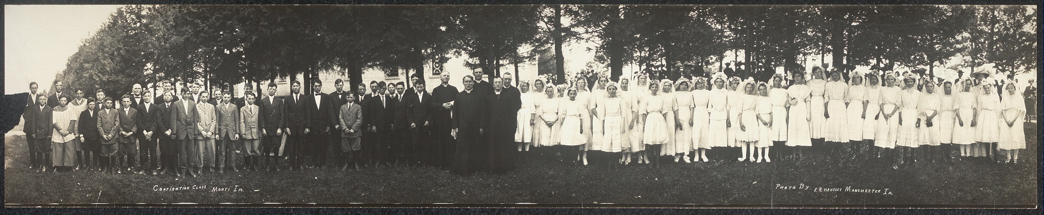
 This is a panoramic photo of the 1913 confirmation class at St. Patrick's Catholic Church in Monti.
Parks and recreation
There are two wildlife areas in Newton Township. The Newton Township Wildlife Area, established in 1998, is a 158-acre (0.64 km2) park located three miles (5 km) southeast of Monti at the eastern edge of the township. Canoeing, fishing, and hunting are permitted at the park. Frogville Access, established in 1978, is a 116-acre (0.47 km2) park between Quasqueton and Troy Mills. It lies in the southwestern corner of the township.[13]
References
- ^ "US Board on Geographic Names". United States Geological Survey. 2007-10-25. http://geonames.usgs.gov. Retrieved 2008-01-31.
- ^ "American FactFinder". United States Census Bureau. http://factfinder.census.gov. Retrieved 2008-01-31.
- ^ a b c d Township Histories
- ^ a b Topo Zone: Buchanan County, Iowa
- ^ a b Articles from 100th Anniversary Edition Independence Conservative; Centennial year 1855-1955
- ^ Anon. (1903-07-02). "Route Is Outlined" Dubuque Telegraph-Herald p. 7.
- ^ Anon. (1904-05-17). "Coup to Get Iowa Road" Dubuque Telegraph-Herald, p. 1.
- ^ Descendants of John W McNamara
- ^ Church, Harry and Chappell, Katharyn Joella (1914). The History of Buchanan County, Iowa, and Its People. The S.J. Clarke Publishing Company. Chicago.
- ^ Official Map of Buchanan County, Iowa June 1, 1956. American Lithographing and Printing Company
- ^ Edmund Arthur Cook IowaGenWeb.org. Accessed 2011-06-01.
- ^ "School district plans anniversary open house", Waterloo Courier: A7, 1986-05-21
- ^ Buchanan County Conservation Report, 2004-2005 Last accessed 2008-01-26.
External links
- Photograph of Kiene, Iowa, early 20th century, Iowa Digital Library.
- US-Counties.com
- City-Data.com Comprehensive Statistical Data and more about Newton Township
Municipalities and communities of Buchanan County, Iowa County seat: Independence Cities 
Townships Unincorporated
communitiesBryantsburg | Doris | Littleton | Monti | Otterville | Shady Grove
Footnotes ‡This populated place also has portions in an adjacent county or counties
Categories:- Townships in Buchanan County, Iowa


Wikimedia Foundation. 2010.