- Bonita, California
Infobox Settlement
official_name = Bonita, California
settlement_type = CDP
imagesize =
image_caption =
image_
imagesize =
image_caption =
image_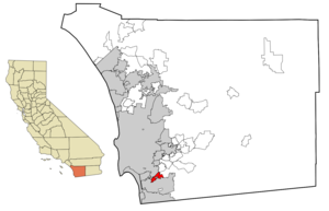
mapsize = 250x200px
map_caption = Location in San Diego County and the state ofCalifornia
mapsize1 =
map_caption1 =
subdivision_type = Country
subdivision_type1 = State
subdivision_type2 = County
subdivision_name =United States
subdivision_name1 =California
subdivision_name2 = San Diego
government_type =
leader_title =
leader_name =
established_date =
area_magnitude =
area_total_km2 = 13.2
area_total_sq_mi = 5.1
area_land_km2 = 12.7
area_land_sq_mi = 4.9
area_water_km2 = 0.5
area_water_sq_mi = 0.2
elevation_ft = 118
elevation_m = 36
population_as_of = 2000
population_footnotes =
population_total = 12401
population_metro =
population_density_km2 = 939.5
population_density_sq_mi = 2431.6
timezone = PST
utc_offset = -8
latd = 32 |latm = 39 |lats = 30 |latNS = N
longd = 117 |longm = 2 |longs = 7 |longEW = W
timezone_DST = PDT
utc_offset_DST = -7
postal_code_type =ZIP code s
postal_code = 91902, 91908
area_code = 619
blank_name = FIPS code
blank_info = 06-07414
blank1_name = GNIS feature ID
blank1_info = 1660356
footnotes =
website =Bonita is an unincorporated
community in southernSan Diego County, California , nestled between the cities of Chula Vista, National City, and San Diego. It is also acensus-designated place defined by theU.S. Census Bureau .Geography
Bonita is located at coor dms|32|39|30|N|117|2|7|W|city (32.658420, -117.035336)GR|1.
According to the
United States Census Bureau , Bonita has a total area of 13.2 km² (5.1 mi²). 12.7 km² (4.9 mi²) of it is land and 0.5 km² (0.2 mi²) of it (3.54%) is water.While Bonita is politically designated as an unincorporated community, bounded by the incorporated cities of Chula Vista, San Diego, and National City the community of Bonita is more closely associated with the geography of the Lower Sweetwater Valley. Thus considered, Bonita occupies about a five mile (8 km) stretch of the Sweetwater River, its valley, and surrounding hills on either side, bounded upstream (east) by the
Sweetwater Reservoir , and downstream (west) effectively by Interstate 805. The community crosses west of I-805 -- an area less than 160acres (0.6 km²) -- reaching as far south and west as East H Street and Hilltop Drive. Its northern boundary is State Route 54 and its southern extent reaches approximately one mile (2 km) south of the river.Large portions of modern Bonita consist of housing tracts built throughout the 1960s, 1970s, and 1980s, including:
*Bonita Downs
*Bonita Fairways
*Bonita Glen
*Bonita Highlands
*Bonita Long Canyon
*Bonita Woods
*Emerald Ranch
*Lynwood Hills
*Ames RanchHistory
In 1888, the
Sweetwater Dam was built, creating theSweetwater Reservoir and forever changing the geography of the region. Soon after, in 1906, the dam broke as a result of extensive rains which overfilled the reservoir, and the Lower Sweetwater Valley was completely flooded.Bonita has experienced minor flooding throughout history, generally as a result of high seasonal rains attributed to
El Niño . The floods most affect the Central Avenue river crossing, as no bridge has ever been built, unlike the Bonita Road and Willow Road crossings which are bridges, the former of which was rebuilt in the late 1990s.In the 1990s and 2000s, the development of State Route 125 (The South Bay Expressway) became a major issue to Bonita residents, much as Interstate 805 and State Route 54 did during their development. Opponents argued that Bonita's rural nature would be compromised without benefit while proponents argued that the highway would reduce the significant increase in surface-street car traffic the community had seen since the 1980s when the eastern Chula Vista communities surrounding Eastlake were developed. The tollway opened in November 2007.
The Bonita Historical Museum is the principal repository of historical information for the Lower Sweetwater Valley.
Climate
The climate in Bonita is a combination of the coastal and inland valley climates of
San Diego County . Warmer (and sunnier during theMay Gray andJune Gloom periods) than areas directly adjacent toSan Diego Bay or the coast, but not as hot as inland valleys such as El Cajon, or even nearby Spring Valley. In summer, Bonita's climate is pleasant.Government
*
San Diego County District 1 (Greg Cox)In the state legislature Bonita is located in the 36th and 40th Senate District, represented by Republican
Dennis Hollingsworth and DemocratDenise Moreno Ducheny , and in the 78th and 79th Assembly District, represented by RepublicanShirley Horton and DemocratMary Salas respectively. Federally, Bonita is located inCalifornia's 51st congressional district , which has a Cook PVI of D +7 [cite web | title = Will Gerrymandered Districts Stem the Wave of Voter Unrest? | publisher = Campaign Legal Center Blog | url=http://www.clcblog.org/blog_item-85.html | accessdate = 2008-02-10] and is represented by DemocratBob Filner .Educational institutions
The following schools serve (or served) the local Bonita community:
*Chula Vista Elementary School District
**Ella B. Allen Elementary School
**Southwestern Satellite School (closed)
**Sunnyside Elementary School
**Tiffany Elementary School (Chula Vista )
**Valley Vista Elementary School
*Sweetwater Union High School District
**Bonita Vista Middle School (Chula Vista )
**Bonita Vista High School (Chula Vista )
*Southwestern College (Chula Vista )Parks and recreation
To visitors and residents alike, one of the most visible features of Bonita recreational life is the walking trail which loops the Chula Vista Municipal Golf Course in central Bonita. Hundreds of residents walk, run, and ride this trail every day for pleasure and fitness, and the trail has become a vital component of Bonita life for many residents.
In the late 1990s the Sweetwater Regional Park was expanded and significantly improved, extending the walking and equestrian trails to an even greater number, and introducing a camping area at Summit Meadow Road. Now, virtually the entire valley from the reservoir to I-805 formally serve recreational purposes as either park or golf course.
Equestrianism has long been a part of the Bonita community, and many trails exist throughout the Lower Sweetwater Valley. There are a number of connections to trails external to Bonita as well. In fact many residents still keep their own horses and can be seen riding the trails regularly. The Bonita Valley Trails organization monitors and supports the network of trails throughout the valley.
The following parks serve the Bonita community:
*Fred H. Rohr Park
*Sweetwater Regional Park
*Sweetwater Reservoir Riding and Hiking Trail
*Bonita Golf Course
*Chula Vista Municipal Golf CourseClubs and organizations
*Bonita Agua Dulce 4-H Club
* [http://www.bonitacalifornia.org/ Bonita Business & Professional Association]
*Kiwanis Club of Bonita
* [http://bonitaoptimist.optimistweb.org/ Bonita Optimist Club]
* [http://www.bonitaroadrunners.com/ Bonita Road Runners]
*Bonita Valley Garden Club
* [http://bonitatrails.org/ Bonita Valley Trails]
* [http://www.angelfire.com/nf/spectreroms/lp/index.htm Las Primeras]
* [http://www.sweetwatervalleyca.org/ Sweetwater Valley Civic Association]
* [http://www.hometeamsonline.com/teams/default.asp?u=SWVLL&sport=baseball&t=c&p=home&s=baseball Sweetwater Valley Little League]
*Sweetwater Woman's Club
* [http://sunnysidesaddleclub.org/ Sunnyside Saddle Club]Events
Bonitafest is an annual community event, held in early autumn, highlighted by a parade and street fair along Bonita Road which includes crafts, music, entertainment, and food. The Kiwanis Club hosts a Bonitafest Golf Tournament in conjunction with this event.Demographics
As of the 2000
census ,GR|2 there were 12,401 people, 4,179 households, and 3,397 families residing in Bonita. Thepopulation density was 977.2/km² (2,533.3/mi²). There were 4,281 housing units at an average density of 337.3/km² (874.5/mi²). The racial makeup of the CDP was 71.99% White, 3.11% African American, 0.56% Native American, 8.54% Asian, 0.31% Pacific Islander, 10.64% from other races, and 4.84% from two or more races. Hispanic or Latino of any race were 30.47% of the population.There were 4,179 households out of which 35.3% had children under the age of 18 living with them, 66.4% were married couples living together, 10.9% had a female householder with no husband present, and 18.7% were non-families. 14.0% of all households were made up of individuals and 5.3% had someone living alone who was 65 years of age or older. The average household size was 2.94 and the average family size was 3.22.
In Bonita the population is spread out with 24.4% under the age of 18, 7.3% from 18 to 24, 25.5% from 25 to 44, 28.3% from 45 to 64, and 14.5% who were 65 years of age or older. The median age was 41 years. For every 100 females there were 95.1 males. For every 100 females age 18 and over, there were 92.2 males.
The median income for a household in the CDP was $70,109, and the median income for a family was $79,333. Males had a median income of $50,495 versus $39,653 for females. The
per capita income for Bonita is $31,131. About 2.1% of families and 3.7% of the population were below thepoverty line , including 2.2% of those under age 18 and 2.0% of those age 65 or over.External links
Wikimedia Foundation. 2010.