- Oil Trough, Arkansas
-
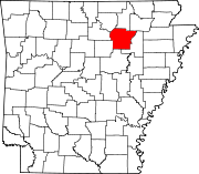
Oil Trough, Arkansas — Town — Location in Independence County and the state of Arkansas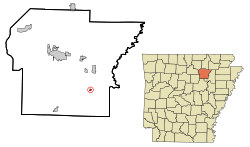
Coordinates: 35°37′46″N 91°27′41″W / 35.62944°N 91.46139°WCoordinates: 35°37′46″N 91°27′41″W / 35.62944°N 91.46139°W Country United States State Arkansas County Independence Area – Total 0.2 sq mi (0.5 km2) – Land 0.2 sq mi (0.5 km2) – Water 0 sq mi (0 km2) Elevation 226 ft (69 m) Population (2000) – Total 218 – Density 1,090/sq mi (436/km2) Time zone Central (CST) (UTC-6) – Summer (DST) CDT (UTC-5) ZIP code 72564 Area code(s) 870 FIPS code 05-51410 GNIS feature ID 0077897 Oil Trough is a town in Independence County, Arkansas, United States. The population was 218 at the 2000 census. The town is believed to have acquired its name in the early 19th century from a trough used to render bear fat, which was sold to customers in New Orleans. [1]
Odell Pollard, a retired attorney from Searcy and the Arkansas Republican Party chairman from 1966–1970, graduated from Oil Trough High School.
Contents
Geography
Oil Trough is located at 35°37'46" North, 91°27'41" West (35.629572, -91.461366)[1].
According to the United States Census Bureau, the town has a total area of 0.5 km² (0.2 mi²), all land.
Only Highway
 Arkansas Highway 14
Demographics
As of the census[2] of 2000, there were 218 people, 95 households, and 66 families residing in the town. The population density was 443.0/km² (1,139.0/mi²). There were 105 housing units at an average density of 213.4/km² (548.6/mi²). The racial makeup of the town was 93.58% White, 3.21% Black or African American, 1.38% Native American, and 1.83% from two or more races.
There were 95 households out of which 34.7% had children under the age of 18 living with them, 49.5% were married couples living together, 12.6% had a female householder with no husband present, and 30.5% were non-families. 29.5% of all households were made up of individuals and 14.7% had someone living alone who was 65 years of age or older. The average household size was 2.29 and the average family size was 2.74.
In the town the population was spread out with 27.5% under the age of 18, 4.6% from 18 to 24, 27.5% from 25 to 44, 27.1% from 45 to 64, and 13.3% who were 65 years of age or older. The median age was 38 years. For every 100 females there were 98.2 males. For every 100 females age 18 and over, there were 90.4 males.
The median income for a household in the town was $31,528, and the median income for a family was $33,750. Males had a median income of $30,500 versus $21,250 for females. The per capita income for the town was $14,079. About 13.3% of families and 11.0% of the population were below the poverty line, including 9.6% of those under the age of eighteen and 22.2% of those sixty five or over.
References
- ^ "US Gazetteer files: 2010, 2000, and 1990". United States Census Bureau. 2011-02-12. http://www.census.gov/geo/www/gazetteer/gazette.html. Retrieved 2011-04-23.
- ^ "American FactFinder". United States Census Bureau. http://factfinder.census.gov. Retrieved 2008-01-31.
Municipalities and communities of Independence County, Arkansas Cities Batesville | Cave City‡ | Newark
Towns Cushman | Magness | Moorefield | Oil Trough | Pleasant Plains | Sulphur Rock
Unincorporated
communitiesFootnotes ‡This populated place also has portions in an adjacent county or counties
Categories:- Populated places in Independence County, Arkansas
- Towns in Arkansas


Wikimedia Foundation. 2010.