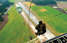
- Naval Outlying Field Coupeville
-
NOLF Coupeville 
IATA: none – ICAO: KNRA – FAA LID: NRA Summary Airport type Military Operator US Navy Location Island County, near Coupeville, Washington Elevation AMSL 199 ft / 61 m Coordinates 48°11′00″N 122°38′00″W / 48.1833333°N 122.6333333°WCoordinates: 48°11′00″N 122°38′00″W / 48.1833333°N 122.6333333°W Runways Direction Length Surface ft m 14/32 5,400 1,646 Concrete Naval Outlying Field Coupeville (ICAO: KNRA, FAA LID: NRA) is a military airport located two miles (3 km) southeast of Coupeville, Washington, in Island County. It is owned by the United States Navy. [1] NOLF Coupeville nearly touches State Route 20 and is about 10 miles south of NAS Whidbey Island.
References
External links
 Media related to Naval Outlying Field Coupeville at Wikimedia Commons
- NOLF Coupeville (GlobalSecurity.org)
- Resources for this U.S. military airport:
- AirNav airport information for KNRA
- ASN accident history for NRA
- NOAA/NWS latest weather observations
- SkyVector aeronautical chart for KNRA
 ArmyFortGray Army Airfield • Vagabond Army AirfieldRange
 NavyCoupevilleStation
 Air ForceJoint Base Lewis-McChord • Fairchild Air Force BaseRange
 National Guard
 Coast GuardStationBellingham • Everett • Ilwaco • La Push • Neah Bay • Port Angeles • Port Townsend • Seattle • Tacoma • WestportSupport CenterSeattleCategories:
- Airports in Washington (state)
- Buildings and structures in Island County, Washington
- United States Naval Outlying Fields
- Transportation in Island County, Washington
- United States Navy stubs
- Western United States airport stubs
- Washington (state) building and structure stubs
Wikimedia Foundation. 2010.
