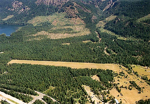
- Easton State Airport
Infobox Airport
name = Easton State Airport
nativename =
nativename-a =
nativename-r =

image-width =
caption =
IATA = ESW
ICAO = KESW
type = Public
owner =
operator =Washington State Department of Transportation
city-served =
location = Easton, Washington
elevation-f =
elevation-m =
coordinates = Coord|47|15|15|N|121|11|13|W|type:airport|display=inline,title
website =
metric-elev =
metric-rwy =
r1-number = 9/27
r1-length-f = 2,640
r1-length-m = 805
r1-surface = Turf, in fair condition
stat-year =
stat1-header =
stat1-data =
stat2-header =
stat2-data =
footnotes =Easton State Airport Airport codes|ESW|KESW was constructed in the 1930s by the federal government as an emergency field for DC-3s crossing the Cascades through
Snoqualmie Pass . It was acquired by the state in 1958 to preserve it for future use. Easton remains as an important airport on the eastern approaches to Snoqualmie andStampede Pass . Perhaps one of our most visited airports, it has the ingredients to make it a one-of-a-kind airport. This field has medium intensity runway lighting coupled with ample room for parking, camping, hiking, and just relaxing in the quiet of nature. There is a stream at the east end of the airport which runs as clear as any you have seen. A small store is approximately one mile south on the access road.The runway is 2,640 feet of turf, with a 300 foot
displaced threshold on the west end. Field elevation is 2,221 feet, anddensity altitude problems can be encountered in the summer. Trees surround the airport and there are trees in both approaches close in. Deer, elk, and motorcyclists also enjoy the airport. The surface is somewhat rough, and will be soft when wet. We recommend an overflight to check field conditions and obstructions. The airport is generally open fromJune 1 to October 1st.The airport is visited by approximately 30 aircraft per month. It is an excellent facility for mountain flying / soft field practice. Glider and flying clubs frequently use the field during the summer.
External links
* [http://www.wsdot.wa.gov/aviation/airports/Easton.htm Easton State Airport] at the
Washington State Department of Transportation .
*PDF| [http://www.wsdot.wa.gov/aviation/PilotsGuide/PilotsGuide_Easton_EastonState.pdf Pilot's Guide to Washington Airports - Easton State Airport]
Wikimedia Foundation. 2010.
