- Grant County International Airport
Infobox Airport
name = Grant County International Airport
nativename =
nativename-a =
nativename-r =
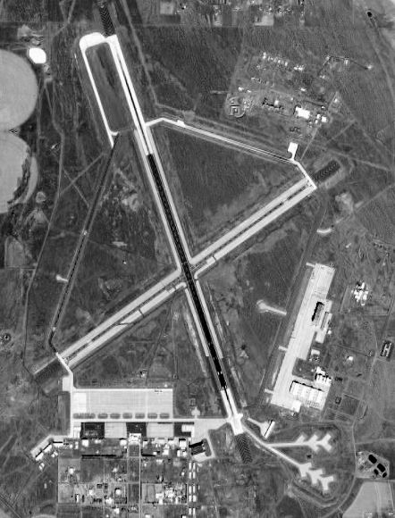
image-width =
caption =
IATA = MWH
ICAO = KMWH
FAA = MWH
type = Public
owner =
operator = Port of Moses Lake
city-served =
location = Moses Lake, Washington
elevation-f = 1,185
elevation-m = 361.2
coordinates = Coord|47|12|28|N|119|19|13|W|type:airport_region:US|display=inline,title
website =
metric-elev =
metric-rwy =
r1-number = 14L/32R
r1-length-f = 13,503
r1-length-m = 4,116
r1-surface =Asphalt /Concrete /Grooved
r2-number = 4/22
r2-length-f = 10,000
r2-length-m = 3,048
r2-surface = Asphalt/Concrete/Grooved
r3-number = 9/27
r3-length-f = 4,500
r3-length-m = 1,372
r3-surface = Concrete/Grooved
r4-number = 18/36
r4-length-f = 3,307
r4-length-m = 1,008
r4-surface = Asphalt
r5-number = 14R/32L
r5-length-f = 2,937
r5-length-m = 895
r5-surface = Concrete
stat-year =
stat1-header =
stat1-data =
stat2-header =
stat2-data =
footnotes =Grant County International Airport Airport codes|MWH|KMWH|MWH is a public
airport located five miles (8 km) northwest of thecentral business district (CBD) of Moses Lake, in Grant County,Washington . Its convert|13500|ft|m|sing=on runway is one of the longest in the U.S..Until 1966, the facility was operated by the U.S. Air Force as Larson Air Force Base. [http://www.strategic-air-command.com/bases/Larson_AFB.htm]
Overview
With convert|4700|acre|ha|0|lk=on and a main runway convert|13500|ft|m|0|lk=on in length, it is one of the largest airports in the United States. Moses Lake is famous for good flying weather, as it is located on the east side of the
Cascade Mountains , in the semi-arid desert of centralWashington state.Grant County International Airport is an alternate landing site for the NASA Space Shuttle. [ [http://www.globalsecurity.org/space/facility/sts-els.htm Space Shuttle Emergency Landing Sites ] ]
Scheduled passenger flights on
Big Sky Airlines to Boise and Portland were discontinued on September 1, 2006. The service was subsidized by theEssential Air Service program.The airport is now used for heavy jet training by
Japan Airlines . It is also utilized by the U.S. Air Force andBoeing as a testing facility. Most of the traffic at the airport is general and military aviation.The main campus for
Big Bend Community College is also located on the grounds of the airport.History
Larson Air Force Base, originally named Moses Lake Army Air Base, was activated on
November 24 ,1942 as a temporaryWorld War II training center. Its first assigned mission was to train pilots for theP-38 Lightning fighter and later to train combat crews for theB-17 Flying Fortress bombers.Major [http://www.web-birds.com/8th/339/505/r45-13a.jpgDonald A. Larson] , for whom the base was later renamed, was from
Yakima, Washington . He waskilled in action August 4, 1944, on a fighter mission overGermany while attached to the 505th Fighter Squadron. He had flown 57 combat missions when hisP-51D Mustang (#44-13881) with the nose-name "Mary Queen of Scotts" crashed near Ulzen,Germany . Larson is buried in the Ardennes American Cemetery at Neuville-en-Condroz, nine miles (14 km) west of Liège,Belgium .In 1945, base activity was curtailed to standby and for three years, was used to test two famous bomber aircraft: the B-47 and the B-50. Even though Larson AFB was on standby, it was still playing a critical role in the development of the USAF aircraft. In 1949, a B-47 took-off from Larson, headed east and began a coast-to-coast speed race. The plane set a new record, completing the flight in just three hours and forty-five minutes, at an average speed of 607.2 mph (977 km/h).
Larson reopened as a permanent installation in 1948 under the
Air Defense Command (ADC). The base came under the 142nd Air Defense Wing based inSpokane . Known ADC squadrons assigned to Larson were:* 317th Fighter-Interceptor Squadron (1948-1950) (F-82)
* [http://www.globalsecurity.org/military/agency/usaf/116ars.htm 116th Fighter-Interceptor Squadron] (Feb - Aug 1951) (F-86A)
(WashingtonAir National Guard squadron called to active duty during theKorean War , activated at Moses Lake, then deployed as part of 81st TFW toRAF Shepherds Grove ,England to provide air defense of the UK as part ofNATO .)
* 82d Fighter-Interceptor Squadron (1952-1953) (F-94B)
* 323d Fighter-Interceptor Squadron (1952-1955)(F-86D)
* 31st Fighter-Interceptor Squadron (1953-1956) (F-86D)
* 322d Fighter-Interceptor Squadron (1955-1959) (F-86D)
* 538th Fighter-Interceptor Squadron (1955-1960) (F-86D/L, F-104A/B)The primary mission of Larson-based ADC aircraft was to protect the secret Hanford Atomic Works and
Grand Coulee Dam .During 1952, Larson AFB was assigned to the
Tactical Air Command (TAC) and the 62nd Troop Carrier Wing moved from McChord AFB,Washington . For the next eight years, the 62nd was very active, supportingDEW Line construction, mercy flights to Formosa andAfrica . Larson became aMilitary Air Transport Service (MATS) base in 1957.From 1955-59, the
Air Materiel Command Flight Test Center at Larson tested the B-52 bomber. Boeing built a huge hangar, convert|1068|ft|m long, convert|372|ft|m wide, with clear spans of convert|217|ft|m and able to hold eight B-52s under one roof.On 26 January 1955, the
Strategic Air Command (SAC) 71st Strategic Reconnaissance Wing was activated to perform strategic reconnaissance withB-36 andRB-36 Peacekeeper bomber. The wing was also assigned to test a technique for launching small RBF-84 Thunderjet aircraft from specially-configued GRB-36 Peacekeeper bombers, to extend the range of photographic reconnaissance and fighter escort. Tests ended in 1956, but the wing continued bombardment training and strategic reconnaissance until inactivated in 1957.In 1960, the 62nd Troop Carrier Wing returned to
McChord AFB with itsC-124 Globemaster II aircraft, where it continues to operate today as the62d Airlift Wing withC-17 Globemaster III aircraft. SAC assumed command of Larson AFB in 1960 and established the4170th Stregic Wing , later renamed the462d Strategic Aerospace Wing as a part ofFifteenth Air Force (15 AF). The568th Strategic Missile Squadron was activated in 1961 as part of the4170th Strategic Wing. In the early 1960s, there were three missile complexes, each housing threeTitan I missiles. The complexes were deactivated in March 1965; they were located at Royal City, Warden, and Odessa.The 462nd also operated
B-52 andKC-135 aircraft, conducting strategic bombardment, air refueling and associated SAC Nuclear Alert Force operations until the wing's inactivation in April 1966.Legendary
World War II hero, ColonelClyde W. Owen , was assigned by SAC as the base commander.In November 1964, it was announced that Larson AFB would be closed due to budget reductions. The 462nd Strategic Aerospace Wing was inactivated in April 1966 and the base was closed on 30 June 1966. With the closure of the base, Colonel Owen retired from the Air Force and became the first director of the Port of Moses Lake, overseeing the transfer of the property from the U.S. Government to Grant County International Airport. Despite the Air Force's departure, the airfield has continued to support operations from McChord's
62d Airlift Wing over the years, as the wing'sC-141 ,C-130 and currently C-17 aircraft have practiced approaches and both normal landings and tactical assault landings on a regular basis.
1948 - 1960
1952 - 1957 Military_Air_Transport_Service
1957 - 1960
1960 - 1966ee also
*
Washington World War II Army Airfields
*Western Air Defense Force (Air Defense Command)References
* [http://www.portofmoseslake.com/gcia.htm Grant County International Airport] (Port of Moses Lake)
*
* [http://www.strategic-air-command.com/bases/Larson_AFB.htm Strategic-Air-Command.com] - Larson AFB history
* [http://www.globalsecurity.org/wmd/facility/larson.htm Global Security.org] - Larson AFBExternal links
* WSDOT Pilot's Guide: [http://www.wsdot.wa.gov/aviation/PilotsGuide/PilotsGuide_MosesLake_GrantCounty.pdf Grant County] (PDF 67 kb)
* WSDOT Economic Impacts: [http://www.wsdot.wa.gov/aviation/EconImpacts/NCR/NCR_GrantCounty.pdf Grant County International Airport] (PDF 427 kb)
*
Wikimedia Foundation. 2010.