- D'Entrecasteaux National Park
-
D'Entrecasteaux National Park 
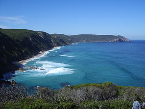
Near Long Point, D'Entrecasteaux National ParkLocation Southwestern Western Australia Nearest city Manjimup Coordinates 34°44′49″S 116°06′54″E / 34.74694°S 116.115°ECoordinates: 34°44′49″S 116°06′54″E / 34.74694°S 116.115°E Area 118,779 ha[1] Established 1980 Governing body Department of Environment and Conservation Official website D'Entrecasteaux National Park is a national park in Western Australia (Australia), 315 kilometres (196 mi) south of Perth. The park is named after the French Admiral Bruni D'Entrecasteaux who was the first European to sight the area and name Point D'Entrecasteaux in 1792.[2]
Contents
Description
The park stretches 130 km (81 mi) from Black Point in the west to Long Point in the east and extends inland as far as 20 km (12 mi). Black Point is made of basalt columns from a lava flow that occurred 135 million years ago. An interesting feature in the park is Yeagarup dune, a mobile 10-kilometre (6.2 mi) long sand dune found to the west of Lake Jasper.[3]
The park contains a great variety of scenery including beaches, sand-dunes, coastal cliffs, coastal heath and pockets of Karri forest. Rivers such as the Warren, the Donnelly and the Shannon flow through the park and discharge into the waters off-shore.
Important large scale wetlands, known as the Blackwater, and lakes such as Lake Jasper and Lake Yeagarup are found within the park boundaries.[4]
Broke Inlet is contained within the park boundaries at iys eastern end; it is the only inlet in the South West that has not been significantly altered within the catchment area. The gneiss basement rocks project through the shallow waters to form small islands in the Inlet.
Sandy Island in Windy Harbour is part of the park; it is an important nesting site for seabirds, with up to 300,000 breeding pairs of Flesh-footed Shearwaters, a high proportion of the global population.[5]
Facilities
The park has an entry fee that applies to all visitors. Facilities available to visitors include barbecues, toilets, 4WD tracks, camp sites, disabled access and picnic areas. Canoeing facilities also exist within the park on the Deep River. Rangers regularly patrol the area.[4]
The Bibbulmun Track passes through the park area.
The outdoor education organisation, Outward Bound, operate within the park taking school groups on hiking expeditions.
See also
References
- ^ Department of Environment and Conservation 2009–2010 Annual Report. Department of Environment and Conservation. 2010. pp. 48. ISSN 1835-114X. http://www.dec.wa.gov.au/content/view/6139/2345/.
- ^ "D'Entrecasteaux National Park". 2008. https://www.dec.wa.gov.au/component/option,com_docman/Itemid,1/gid,2602/task,doc_download/. Retrieved 2009-03-04.
- ^ "West Australia Albany - D'Entrecasteaux National Park". 2009. http://www.coastshop.com.au/national_parks/wa/D'Entrecasteaux.htm. Retrieved 2009-03-04.
- ^ a b "Department of Environment - Parkfinder". 2009. http://www.dec.wa.gov.au/component/option,com_hotproperty/task,view/id,93/Itemid,755/. Retrieved 2010-09-26.
- ^ "IBA: Sandy Island (Windy Harbour)". Birdata. Birds Australia. http://www.birdata.com.au/iba.vm. Retrieved 2011-10-03.
National parks of Western Australia Alexander Morrison · Avon Valley · Badgingarra · Beedelup · Beelu · Boorabbin · Brockman · Cape Arid · Cape Le Grand · Cape Range · Collier Range · D’Entrecasteaux · Drovers Cave · Drysdale River · Eucla · Fitzgerald River · Francois Peron · Frank Hann · Geikie Gorge · Gloucester · Goongarrie · Gooseberry Hill · Greenmount · Gull Rock · Hassell · Hidden Valley · John Forrest · Kalamunda · Kalbarri · Karijini · Karlamilyi · Kennedy Range · Leeuwin-Naturaliste · Lesmurdie Falls · Lesueur · Millstream-Chichester · Mirima · Mitchell River · Moore River · Mount Augustus · Mount Frankland · Nambung · Neerabup · Peak Charles · Porongurup · Purnululu · Rudall River · Scott · Serpentine · Shannon · Sir James Mitchell · Stirling Range · Stokes · Tathra · Torndirrup · Tuart Forest · Tunnel Creek · Walpole-Nornalup · Walyunga · Warren · Watheroo · Waychinicup · West Cape Howe · William Bay · Windjana Gorge · Wolfe Creek Meteorite Crater · Yalgorup · YanchepCategories:- IUCN Category II
- National parks of Western Australia
- Protected areas established in 1980
- South coast of Western Australia
- 1980 establishments in Australia
- Western Australia geography stubs
Wikimedia Foundation. 2010.


