- Nambung National Park
-
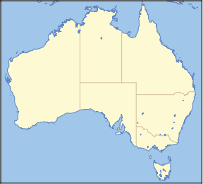
Nambung National Park Map of Australia
Nearest town/city Cervantes Coordinates 30°34′34″S 115°10′12″E / 30.57611°S 115.17°ECoordinates: 30°34′34″S 115°10′12″E / 30.57611°S 115.17°E Area 19,268 ha (47,612 acres)[1] Established 1968 Managing authorities Department of Environment and Conservation Official site NatureBase - Nambung National Park Nambung National Park is a national park in the Wheatbelt region of Western Australia (Australia), 162 km northwest of Perth. It contains the Pinnacles Desert.
Nambung is an Indigenous Australian word meaning crooked or winding referring to the Nambung River that drains into the area.
The park is bordered to the north by Southern Beekeepers Nature Reserve and to the south by Wanagarren Nature Reserve. A large area of vacant Crown Land is found along much of the eastern edge.[2]
Europeans first visited the area in 1658 when Dutch maps recorded North and South Hummocks on their maps. Philip Parker King also mentioned the Hummocks in his journals in 1820. The Pinnacles Desert area remained relatively unknown until surveyed in the late 1960s after the area had been added to an existing national park that was formed in 1956.
Visitors can access the "Pinnacles" from Cervantes, 17 km north of the park, via Cervantes Road and Indian Ocean Drive. With the opening of the final (south) section of Indian Ocean Drive from Lancelin to Cervantes on 19 September 2010, visitors travelling from Perth can now access the "Pinnacles" Nambung National Park directly via Indian Ocean Drive.
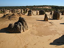 Natural limestone formations commonly known as the Pinnacles
See also
References
- ^ Department of Environment and Conservation 2009–2010 Annual Report. Department of Environment and Conservation. 2010. pp. 48. ISSN 1835-114X. http://www.dec.wa.gov.au/content/view/6139/2345/.
- ^ "Nambung National Park Management Plan 1998-2008". 1998. http://www.dec.wa.gov.au/pdf/nature/management/nambung.pdf. Retrieved 2010-10-23.
National parks of Western Australia Alexander Morrison · Avon Valley · Badgingarra · Beedelup · Beelu · Boorabbin · Brockman · Cape Arid · Cape Le Grand · Cape Range · Collier Range · D’Entrecasteaux · Drovers Cave · Drysdale River · Eucla · Fitzgerald River · Francois Peron · Frank Hann · Geikie Gorge · Gloucester · Goongarrie · Gooseberry Hill · Greenmount · Gull Rock · Hassell · Hidden Valley · John Forrest · Kalamunda · Kalbarri · Karijini · Karlamilyi · Kennedy Range · Leeuwin-Naturaliste · Lesmurdie Falls · Lesueur · Millstream-Chichester · Mirima · Mitchell River · Moore River · Mount Augustus · Mount Frankland · Nambung · Neerabup · Peak Charles · Porongurup · Purnululu · Rudall River · Scott · Serpentine · Shannon · Sir James Mitchell · Stirling Range · Stokes · Tathra · Torndirrup · Tuart Forest · Tunnel Creek · Walpole-Nornalup · Walyunga · Warren · Watheroo · Waychinicup · West Cape Howe · William Bay · Windjana Gorge · Wolfe Creek Meteorite Crater · Yalgorup · YanchepCategories:- IUCN Category II
- National parks of Western Australia
- Protected areas established in 1969
- Western Australia geography stubs


Wikimedia Foundation. 2010.