- Mount Holyoke
-
Mount Holyoke 
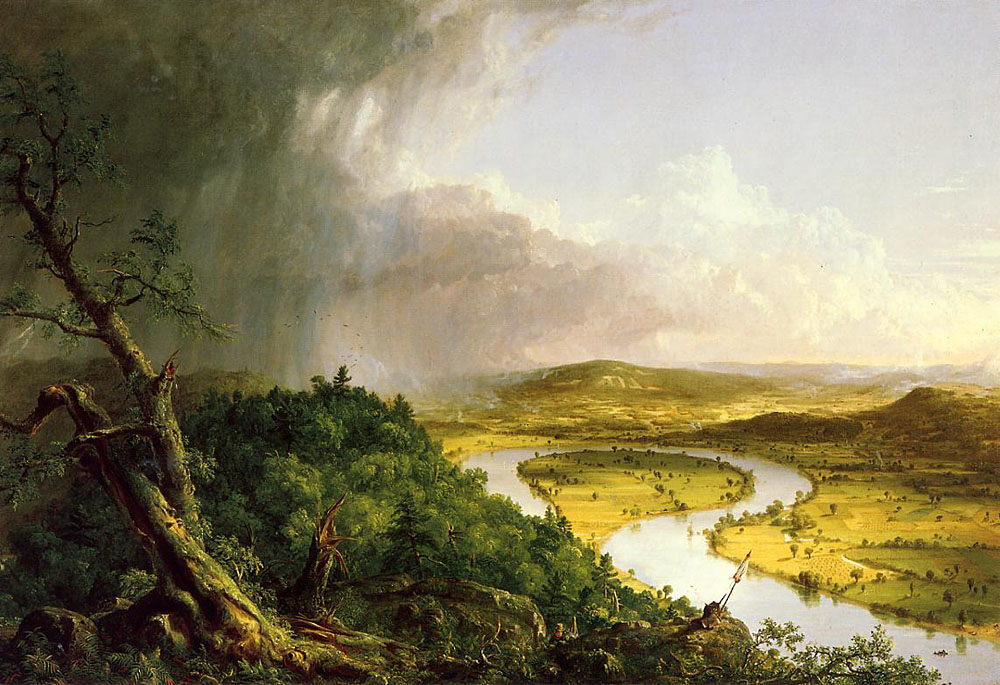
View of the Connecticut River Oxbow from Mount Holyoke summit. 1836 painting by Thomas Cole.Elevation 935 ft (285 m) Location Location Hadley and South Hadley, Massachusetts Range Holyoke Range / Metacomet Ridge Coordinates 42°18′03″N 72°35′13″W / 42.30083°N 72.58694°WCoordinates: 42°18′03″N 72°35′13″W / 42.30083°N 72.58694°W Geology Type Fault-block; igneous Age of rock 200 million years Climbing Easiest route Auto road Mount Holyoke, a traprock mountain, elevation 935 feet (285 m), is the western-most peak of the Holyoke Range and part of the 100-mile (160 km) Metacomet Ridge. The mountain is located in the Connecticut River Valley of western Massachusetts, and is the namesake of nearby Mount Holyoke College. The mountain is located in the towns of Hadley and South Hadley, Massachusetts.[1] It is known for its historic summit house, auto road, scenic vistas, and biodiversity. The mountain is crossed by the 110-mile (180 km) Metacomet-Monadnock Trail and numerous shorter trails. Mount Holyoke is the home of J.A. Skinner State Park which is accessible from Route 47 in Hadley, Massachusetts.[2][3]
Contents
History
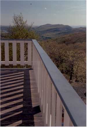
 View from Mount Holyoke Summit House
Origin of name
The mountain was named after Elizur Holyoke, an early resident of Springfield, Massachusetts who first explored the mountainous region that came to bear his name. The city of Holyoke, Massachusetts and Mount Holyoke Female Seminary (now Mount Holyoke College) were both named after the nearby Mount Holyoke and not directly after Elizur Holyoke.[4]
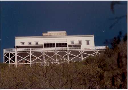
The Mount Holyoke Summit House
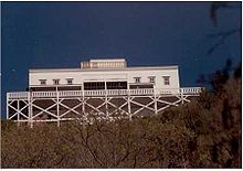 Mount Holyoke Summit House
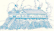 Mt Holyoke Hotel, showing summit house and covered electric tram circa 1931
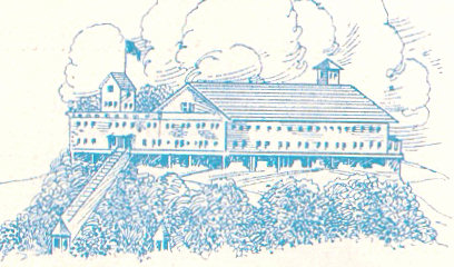
In 1821, an 18-by-24-foot (5.5 by 7.3 m) guest cabin was built on Mount Holyoke by a local committee—one of the first New England summit houses. The property changed hands several times between 1821 and 1851 when it was bought and rebuilt as a two-story, eight-room hotel. Local entrepreneurs John and Frances French were the primary owners; between 1851 and 1900, the hotel and property were subject to a number of upgrades and related construction projects including a covered tramway to the summit of the mountain (first drawn by horse, then mechanized), a railroad from the base of the mountain to a steamboat dock on the Connecticut River, and the construction of a number of outbuildings and trails. With passenger steamship to the connecting summit railway established, the Mount Holyoke "Prospect House" became a popular tourist destination. The steamship would pick up guests at the Smiths Ferry railroad station across the Connecticut River in what was then Northampton, ferry them to a tramway leading to the Half Way House. From there guests could take a steep (600 feet long, rising 365 feet) covered inclined tram to the summit (shown in drawing at right[5]). The track for this tram was first laid in 1867 and the system electrified in 1926. Competing establishments were soon built on Mount Tom and Mount Nonotuck across the Connecticut River, and on Sugarloaf Mountain and Mount Toby to the north. The Prospect House property passed hands again in the early 1900s, to chain hotelier Joseph Allen Skinner, who eventually donated the hotel and property to the Commonwealth of Massachusetts for a state park in 1939 on the condition that the park be named after him (now the J.A. Skinner State Park).
The summit house's 1894 annex had suffered from storm damage during the Great Hurricane of 1938 and had been demolished; in 1942 the enclosed tramway to the summit house broke down. A heavy snow storm in 1948 collapsed sections of the roof. Despite proposals to repair the tram it never ran again. The tram was finally demolished in 1965. State funds for maintenance of the summit house during the 1950s and 1960s were never adequate and by the mid-1970s there were proposals to condemn and demolish the summit house. This led to a public outcry and in the mid-1980s the summit house, consisting of the original 1851 structure and the 1861 addition, was restored by the state and through the efforts of local volunteers.[6]
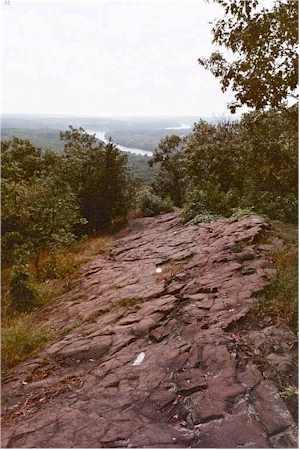
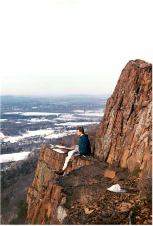
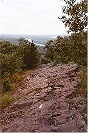 View from Mount Holyoke south ledges along the Metacomet-Monadnock Trail. Connecticut River in background
Geology and ecology
Mount Holyoke, like much of the Metacomet Ridge, is composed of basalt, also called trap rock, a volcanic rock. The mountain formed near the end of the Triassic Period with the rifting apart of the North American continent from Africa and Eurasia. Lava welled up from the rift and solidified into sheets of strata hundreds of feet thick. Subsequent faulting and earthquake activity tilted the strata, creating the dramatic cliffs and ridges of Mount Holyoke.[7] Hot, dry upper slopes, cool, moist ravines, and mineral-rich ledges of basalt talus produce a combination of microclimate ecosystems on the mountain that support plant and animal species uncommon in greater Massachusetts.[2] (See Metacomet Ridge for more information on the geology and ecosystem of Mount Holyoke).
Recreation
The summit automobile road is open from April through November, and the hiking trails year-round. The Summit House is open weekends and holidays from Memorial Day through Columbus Day.[8] A number of hiking trails also cross the mountain, most notably the 110 mile (180k) Metacomet-Monadnock Trail and the 47-mile (76 km) Robert Frost Trail.[3]
Every year in early fall, since 1838, students from nearby Mount Holyoke College participate in Mountain Day. On that day, at the sound of ringing bells from Abbey Chapel on a random Autumn morning, all classes are cancelled and students hike to the summit of Mount Holyoke.[9]
The area around the summit house has many picnic tables. Also, there are trailheads and memorials. One notable memorial is that to the men aboard a transport plane that crashed into the flank of the mountain. On May 27, 1944, a B-24, flying a night training mission out of Westover Air Force Base in Chicopee, Massachusetts, crashed into the side of the range, killing all ten crewmen. A memorial plaque on the summit of Mount Holyoke eulogizes the disaster. The crash site itself is a few hundred feet away.[6]
The views from the top of the mountain are some of the best in Massachusetts. They have inspired artists and poets. The nearby Connecticut River Oxbow (now a lake), immortalized by the famous landscape painter Thomas Cole just four years before natural flooding and erosion separated it from the Connecticut River, was composed from sketches the artist made from the summit of Mount Holyoke in 1836.[10] To the south are the cities of Holyoke, Springfield, and Hartford. To the north are the University of Massachusetts in Amherst and mountains in Sunderland. To the east is the Holyoke Range and the town of South Hadley. To the west are the foothills of the Berkshires, the Connecticut River, and Northampton.
Conservation
Most of Mount Holyoke is located within the Skinner State Park. The Mount Holyoke Range State Park is a sister park occupying the east side of the Holyoke Range. Its visitor center is located at "the Notch", where Route 116 crosses the range in Amherst.[11]
In 2000, Mount Holyoke was included in a study by the National Park Service for the designation of a new National Scenic Trail now tentatively called the New England National Scenic Trail, which would include the Metacomet-Monadnock Trail in Massachusetts and the Mattabesett Trail and Metacomet Trail trails in Connecticut.[12]
See also
- Metacomet Ridge
- Metacomet-Monadnock Trail
- Robert Frost Trail (Massachusetts)
- Adjacent summits:
< West East > Seven Sisters
(no image)Cultural references
- Mount Holyoke is mentioned in Henry James's 1875 novel Roderick Hudson, in chapters II and IX.
References
- ^ DeLorme Topo 6.0. Mapping software. DeLorme. Yarmouth, Maine.
- ^ a b Farnsworth, Elizabeth J. "Metacomet-Mattabesett Trail Natural Resource Assessment." 2004. PDF wefile cited November 1, 2007.
- ^ a b The Metacomet-Monadnock Trail Guide. 9th Edition. The Appalachian Mountain Club. Amherst, Massachusetts, 1999.
- ^ Mount Holyoke College Cited Dec. 6, 2007
- ^ from the personal correspondence of W. Rolfe Brown, August 23, 1931
- ^ a b *Mt. Holyoke Range Historical Timeline Cited November 20, 2007.
- ^ Raymo, Chet and Maureen E. Written in Stone: A Geologic History of the Northeastern United States. Globe Pequot, Chester, Connecticut, 1989.
- ^ "J.S.Skinner State Park" Massachusetts Department of Conservation and Recreation. Cited Dec. 25, 2007.
- ^ Mount Holyoke College
- ^ Roque, Oswaldo Rodriguez (1982). "The Oxbow" by Thomas Cole: Iconography of an American Landscape Painting. Metropolitan Museum Journal. pp. 63-7.
- ^ Massachusetts Department of Conservation and Recreation. Cited Nov. 20, 2007.
- ^ Monadnock, Metacoment, Mattabesett National Scenic Trail Study. Cited Nov. 4, 2007.
External links
- J.A. Skinner State Park Map
- Hampshire College mountain biking map of the Holyoke Range
- Berkshire Chapter of the Appalachian Mountain Club
- The Kestrel Trust
- The Valley Land Fund
- Friends of the Mount Holyoke Range
- U.S. Congress New England National Scenic Trail Designation Act.
- NPS brochure for National Scenic Trail proposal.
- Natural resource assessment of the Metacomet Ridge
- Geology of the northern Metacomet Ridge region
- State website for Skinner State Park
- Save The Mountain, a citizen action group
- Guide to the Robert Frost Trail
- Mt. Holyoke - FranklinSites.com Hiking Guide
Categories:- Landforms of Hampshire County, Massachusetts
- Mountains of Massachusetts
- Holyoke Range
- Visitor attractions in Hampden County, Massachusetts
Wikimedia Foundation. 2010.