- Ain Saadeh
-
Ain Saadeh
عين سعادة— City — Location within Lebanon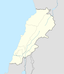
 Ain Saadeh
Coordinates: 33°51′58″N 35°35′42″E / 33.8660°N 35.5951°ECoordinates: 33°51′58″N 35°35′42″E / 33.8660°N 35.5951°E Country  Lebanon
Governorate Mount Lebanon Governorate District Matn District Area – Total 548 km2 (211.6 sq mi) Highest elevation 650 m (2,133 ft) Lowest elevation 400 m (1,312 ft) Time zone EET (UTC+2) – Summer (DST) EEST (UTC+3) Postal code Dialing code +961-4- Ain Saadeh (Arabic: عين سعادة, also spelled Ain Saadée and Ain Saade) is suburb located in the pine-forested hills, northeast of the capital Beirut in Lebanon.
Demography
Ain Saade is a traditional Christian village located in the picturesque of the mountains of Lebanon overlooking the Mediterranean Sea, with some 10,000 population and 2,000 voters. The origin of ‘‘Ain Saade’’ varies and has several routes, one of them refer to the village's natural spring and literary means Spring of Happiness.
As with most villages, Ain Saade has had its share of developments of modern houses in the last century, but is central character remains intact. The village has several nurseries, Schools, Colleges, Technical institute and Universities.
The village has several shops, post office, several pubs, restaurants, 5 stars hotel, garage, etc ... Few modern villages can boast so many amenities. It has an impressive range of active groups including the Legion Marie, Boy Scout, Sports Club, etc...To name a few, not to forget to mention several churches as well as an orphanage. Furthermore, the village has several industrial, commercial, residential and agriculture zones.
The village of Ain Saade is located about 10 kilometers away from Beirut at a latitude ranging between 200 and 700 meters above sea level. There are several possible routes to Ain Saade:
-The first Through Mkalles - Mansourieh - Ain Saade,
-The second through Fanar - Ain Saade,
-The third through Nahr El Mawt, Roumieh - Ain Saade,
-The fourth through Ras el Matn – Ain Saade,
-The fifth through Brummana - Beit Mery - Ain Saade.Etymology
The name "Ain Saadeh" refers to the town's natural spring and literary means, "Spring of Happiness."
 Matn District, Mount Lebanon GovernorateCapital: Jdeideh
Towns and villages Ain Aar · Ain el Safssaf · Ain el Sendianeh · Ain Saadeh · Aintoura · Amaret Chalhoub · Antelias · Aoukar · Ayroun · Baabdat · Baskinta · Bauchrieh · Beit Chabab · Beit el Chaar · Beit el Kekko · Beit Mery · Bhersaf · Biakout · Bikfaya · Bkenneya · Bourj Hammoud · Broummana · Bsalim · Bteghrine · Chaouiyeh · Choueir · Daher al Hosein · Dahr el Sawan · Daychounieh · Dbayeh · Dekwaneh · Dik El Mehdi · Dhour El Choueir · Dora · Douar · Fanar · Ghabeh · Ghabet Bologna · Hadirah · Haret al Ballaneh · Hbous · Jal el Dib · Jdeideh · Jouar · Kaakour · Kfarakab · Kfartay · Khenchara · Majdel Tarchich · Majzoub · Mansourieh · Mar Chaaya · Mar Michael Bnabil · Mar Moussa · Mar Roukouz · Marjaba · Mazraat Yachouh · Mchikha · Mezher · Mhaydseh · Mkalles · Mrouj · Mtaileb · Mtein · Mzekkeh · Nabay · Naccache · Ouyoun · Qonaytrah · Qonnabat Broummana · Qornet Shehwan · Rabieh · Roumieh · Sakiyat al Mesek · Sed el Bauchrieh · Sin el Fil · Wata el Mrouj · Zalka · Zarooun · Zekrite · Zouk al Khrab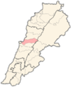
Notable landmarks Notable touristic sites Categories:- Matn District
- Populated places in the Mount Lebanon Governorate


Wikimedia Foundation. 2010.