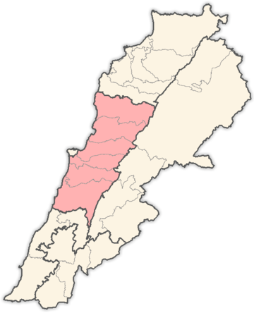
Mount Lebanon Governorate

Mount Lebanon Governorate

Coordinates: 33°50′N 35°32′E / 33.833°N 35.533°E / 33.833; 35.533

Mount Lebanon (جبل لبنان)
Governorate
Country Lebanon
Capital Baabda
Area 1,985 km2 km2 (Expression error: Unrecognised word "km" sq mi)
Timezone UTC+3
Languages Arabic, French

Mount Lebanon (Arabic: جبل لبنانǦabal Libnān) is one of the Governorates of Lebanon. Its capital is Baabda. The overwhelming majority of its population is Maronites, Greek Orthodox, and Melkite Greek Catholic Christians.[citation needed] However, there are also many Muslims in the area, and there is the Druze community.

Districts

The governorate is divided into 6 districts (Aqdya, singular - qadaa or Caza) which are:

Religion in Mount Lebanon Governorate

Christians makes the majority with 67.32%; Druze makes the second most with 18.47%; Sunnis makes the third with 7.33%; Shia are the last with 6.88%.

See also


Wikimedia Foundation. 2010.

Игры ⚽ Поможем сделать НИР

Look at other dictionaries:

  • Mount Lebanon (disambiguation) — Mount Lebanon is a mountain range in the Lebanese Republic, a nation in the Middle East. Mount Lebanon may also refer to: Mount Lebanon Governorate, a political region in modern Lebanon Mount Lebanon Mutasarrifate, one of the former Ottoman… …   Wikipedia

  • Mount Lebanon — For other uses, see Mount Lebanon (disambiguation). Mount Lebanon Lebanon Cedars on the slopes of Mount Lebanon. Note the thawing winter snow cover. Photo April 2004 …   Wikipedia

  • Mount Sannine — (جبل صنين) Mount Sannine as seen from Beirut Elevation 2,628 m ( …   Wikipedia

  • Lebanon — This article is about the country. For other uses of terms redirecting here, see Lebanon (disambiguation) and Liban (disambiguation). Republic of Lebanon اَلْجُمْهُورِيَّة اَللُّبْنَانِيَّة al Jumhūrīyah al Lubnānīyah République libanaise …   Wikipedia

  • Districts of Lebanon — Lebanon This article is part of the series: Politics and government of Lebanon …   Wikipedia

  • Dora, Lebanon — Dora الدورة   City   …   Wikipedia

  • Mezher, Lebanon — Mezher مزهر Ծաղկաձոր   Town   …   Wikipedia

  • Harissa, Lebanon — For an article about sauce see Harissa. Infobox City Lebanon State Party = LBN official name = Harissa native name = حريصا governorate = Mount Lebanon Governorate district = Keserwan District elevation m lo = 600 |elevation m hi=700 mapx = 33.97… …   Wikipedia

  • Nabatieh Governorate — Coordinates: 33°22′N 35°28′E / 33.367°N 35.467°E / 33.367; 35.467 …   Wikipedia

  • North Governorate — For the governorate of Bahrain, see Northern Governorate. Coordinates: 34°26′N 35°51′E / 34.433°N 35.85°E / 34.433; 35.85 …   Wikipedia

Share the article and excerpts

Direct link
Do a right-click on the link above
and select “Copy Link”