- Massachusetts Route 58
-
Route 58
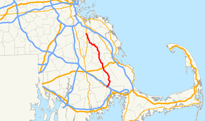
Route information Length: 29.86 mi[1] (48.06 km) Major junctions South end:  Route 28 in Rochester and Wareham
 I-495 in Wareham
 U.S. Route 44 in Carver
North end:  Route 18 in Weymouth
Highway system Massachusetts State Highway Routes
←  Route 57
Route 60  →
→Route 58 is a south–north highway in southeastern Massachusetts. For all but its final 0.4 miles (0.64 km), the route lies within Plymouth County.
Route description
 Southbound entering Hanson
Route 58 begins at Route 28 on the Rochester - Wareham town line.[2][3] The route follows the town line for approximately a tenth of a mile before being wholly in Wareham. It then crosses I-495 before clipping the corner of Middleborough and re-entering Wareham for a short while before finally entering Carver. For the first 1.4 miles (2.3 km) of this route, none of the town line changes are signed.
The route turns northward through the town of Carver, passing Edaville Railroad and the King Richard's Faire grounds as well as the center of town. In North Carver the town intersects U.S. Route 44 just east of where that route becomes a four-lane freeway. Before the freeway was completed, the route had a short concurrency between its current exit ramps to Plymouth Road, where the route continued eastward to Plymouth. Route 58 then passes through the small town of Plympton and into Halifax, where it intersects Route 106. It then passes between the East and West Monponsett Ponds before crossing into Hanson.
In Hanson, Route 58 intersects Route 27 before sharing a 0.4 miles (0.64 km) concurrency with Route 14, passing the Town Hall and Wampatuck Pond before splitting northwestward. The route takes a few turns before entering Whitman, turning northward at a rotary into the town of Abington. It intersects Route 123, the Plymouth/Kingston commuter rail line, and Route 139, all before ending just over the Weymouth town line at Route 18, just west of the former South Weymouth Naval Air Station site.
Junction list
County Location Street Names Milepost Roads Intersected Notes Plymouth Rochester County Road 0.00 Route 28Southern terminus of Route 58. Wareham County Road 0.4 I-495Interstate 495 Exit 2. Signed on overhead signs as Route 58 north. Route 58 south not signed as such at the end of both off-ramps. Carver Tremont Street
South Main Street
Main Street
North Main Street10.3 US 44Interchange. Plympton Main Street
Palmer RoadMayflower Street To  Route 80.
Halifax Monponsett Street 15.8  Route 106
Hanson Monponsett Street
Indian Head Street
Liberty Street
East Washington Street
Spring Street
Whitman Street19.4  Route 27
21.0  Route 14
Southern terminus of Route 14/58 concurrency. 21.4 Route 14Northern terminus of Route 14/58 concurrency. Whitman Plymouth Street No junctions in Whitman Abington Plymouth Street
Adams Street26.6  Route 123
28.0  Route 139
Norfolk Weymouth Pond Street 29.86 Route 18Northern terminus of Route 58. References
- ^ Executive Office of Transportation, Office of Transportation Planning - 2007 Road Inventory
- ^ Massachusetts Atlas & Gazetteer. Yarmouth, Maine: DeLorme, 2002. P. 58, L-9.
- ^ American Map: Metro Boston-Eastern Massachusetts. South Easton, MA: Arrow Map, Inc. 2004. P. 202, A-13.
Categories:- Numbered routes in Massachusetts
- Abington, Massachusetts
- Whitman, Massachusetts
- Rochester, Massachusetts
- Middleborough, Massachusetts
- Wareham, Massachusetts
- Carver, Massachusetts
- Plympton, Massachusetts
- Halifax, Massachusetts
- Hanson, Massachusetts
- Weymouth, Massachusetts
- Transportation in Plymouth County, Massachusetts
- Transportation in Norfolk County, Massachusetts


Wikimedia Foundation. 2010.