Cherry Creek, South Dakota
- Cherry Creek, South Dakota
-
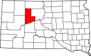
Cherry Creek is an unincorporated community in Ziebach County, South Dakota, United States. Although not tracked by the Census Bureau, Cherry Creek has been assigned the ZIP code of 57622.
Categories: - South Dakota geography stubs
- Populated places in Ziebach County, South Dakota
- Unincorporated communities in South Dakota
Wikimedia Foundation.
2010.
Look at other dictionaries:
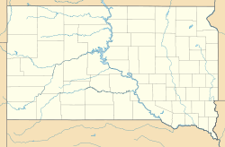
Cherry Creek (South Dakota) — Cherry Creek is a tributary of the Cheyenne River, approximately 50 mi (80 km), in central South Dakota in the United States. It rises in the prairie country of northern Meade County, and flows southeast and east, across the southwest… … Wikipedia
Cherry Creek — may refer to a location in the United States: Cherry Creek (Tuolumne River), a stream in California Cherry Creek (Colorado), a tributary of the South Platte River Cherry Creek, Denver, Colorado, a neighborhood Cherry Creek Shopping Center Cherry… … Wikipedia
Cherry Creek — ist der Name mehrerer Orte in den Vereinigten Staaten: Cherry Creek (Idaho) Cherry Creek (Mississippi) Cherry Creek (Nevada) Cherry Creek (New York) Cherry Creek (South Dakota) Cherry Creek Acres (Kalifornien) Fließgewässer: Cherry Creek (Buffalo … Deutsch Wikipedia
Cherry Creek Bridge — Carries Passenger vehicles Crosses Cherry Creek Locale near Franktown, Colorado … Wikipedia
Ziebach County, South Dakota — Infobox U.S. County county = Ziebach County state = South Dakota founded year = founded date = seat wl = Dupree largest city wl = Dupree area total sq mi = 1971 area total km2 = 5105 area land sq mi = 1962 area land km2 = 5082 area water sq mi =… … Wikipedia
Todd County, South Dakota — Infobox U.S. County county = Todd County state = South Dakota founded year = 1909 [ Legislative Manual, South Dakota, 2005, p. 597] in its present form. (A previous Todd County existed further to the east along the Missouri River.} founded date … Wikipedia
National Register of Historic Places listings in Minnehaha County, South Dakota — Location of Minnehaha County in South Dakota This is a list of the National Register of Historic Places listings in Minnehaha County, South Dakota. This is intended to be a complete list of the properties and districts on the National Register of … Wikipedia
Liste der Flüsse in South Dakota — Die Liste der Flüsse in South Dakota nennt alle Flüsse im US Bundesstaat South Dakota in alphabetischer Reihenfolge und nach Einzugsgebieten geordnet. Inhaltsverzeichnis 1 Alphabetische Reihenfolge 2 Nach Einzugsgebieten 2.1 Einzugsgebiet des… … Deutsch Wikipedia
List of rivers of South Dakota — This is a list of rivers in the state of South Dakota in the United States.Alphabetically*Bad River *Big Sioux River *Belle Fourche River *Bois de Sioux River *Castle Creek *Cherry Creek *Cheyenne River *Elm River *French Creek *Grand River… … Wikipedia
National Register of Historic Places listings in Turner County, South Dakota — Location of Turner County in South Dakota This is a list of the National Register of Historic Places listings in Turner County, South Dakota. This is intended to be a complete list of the properties and districts on the National Register of… … Wikipedia
 Cherry Creek