- Montezuma Hills
-
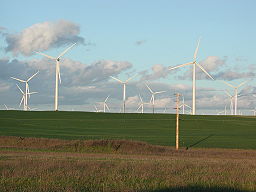
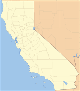
Montezuma Hills Mountain Range A 21st century windfarm in the Montezuma Hills, Solano County, California. Some of these wind turbines are 415ft tall.Country United States State California District Solano County Coordinates 38°7′2.704″N 121°48′15.845″W / 38.11741778°N 121.80440139°W Highest point - elevation 85 m (279 ft) Timezone Pacific (UTC-8) - summer (DST) PDT (UTC-7) Topo map USGS Antioch North location of Montezuma Hills in California [1]The Montezuma Hills comprise a small range of low-elevation hills at the northern banks of the Sacramento River Delta in Solano County, California. The Montezuma Hills are bounded by the Sacramento River on the south and east; the Montezuma Slough on the west and roughly by California State Route 12 on the north. The peaks of these rolling hills vary in height from about 164 to 279 feet.
The hills are known for their exceptional wind energy resource potential which has made them the site of the rapidly expanding Shiloh Wind Power Plant, a wind farm that now comprises hundreds of wind turbines, with another 88 pending approval1. Rio Vista is the nearest city, while Travis Air Force Base is about 10 miles northwest of the Montezuma Hills.
Natural features
The flora and fauna of the Montezuma Hills has been studied extensively beginning in 1988 with the Earth Metrics Environmental Impact Report for proposed wind energy development.[2][3] and continuing with subsequent analyses[4][5][6] that collectively have led to a compreshensive characterization of the local biological resources, plant communities and wildlife habitat.
In general there is little remaining native vegetation in the Montezuma Hills due to the historic intensive grazing.[2][3][5][6] As of 2010, land uses are primarily dryland farming, sheep grazing, and energy, including natural gas production – the Rio Vista Gas Field underlies much of the Montezuma Hills – and wind energy. Wetlands cover only a small percentage of the Montezuma Hills, and virtually all of the sparse trees are non-native species associated with the area's farming homesteads.
Compared to the Suisun Marsh to the south and west, the Montezuma Hills have a relatively unabundant diversity of avafauna and other wildlife. Among the Montezuma Hills are a number of intermittent drainage swales that flow during winter months; otherwise the monotypic dryland farms support even less diversity of wildlife than more agriculturally diverse land uses to the north. Exceptions to the dearth of wildlife are the considerable populations of ground squirrels and other small rodents, which populations in turn support modest numbers of raptors. Birds present in moderate numbers are the red-winged blackbird, cliff swallow, northern harrier and barn swallow. Moderate numbers of avian nests have been documented in the Montezuma Hills including red-tailed hawk, American kestrel and historic nests of the Golden Eagle.
References
- ^ "Montezuma Hills". Geographic Names Information System, U.S. Geological Survey. http://geonames.usgs.gov/pls/gnispublic/f?p=gnispq:3:::NO::P3_FID:228968. Retrieved 2009-05-04.
- ^ a b "Montezuma Hills Avian and Bat Assessment", 2006, Estep and Jones & Stokes
- ^ a b "Environmental Impact Report for the Montezuma Hills Wind Farm", 1988, Earth Metrics, published by the Solano County Department of Environmental Management, Fairfield, California
- ^ "Wind Turbine Effects on Avian Activity, Habitat Use, and Mortality in Altamont Pass and Montezuma Hills", 1993, Sacramento Municipal Utility District, Prepared for the California Energy Commission
- ^ a b "Solano County High Winds Power Project Envionmental Impact Report", 2002, Environmental Science Associates
- ^ a b "Biological Resources Report and Evaluation for the Proposed Shiloh Wind Plant Project", Solano County, Ca.
External links
Categories:- Mountain ranges of Solano County, California
- Mountain ranges of the San Francisco Bay Area
Wikimedia Foundation. 2010.


