- Norwood Park Township, Cook County, Illinois
-
Norwood Park Township — Township — Location in Cook County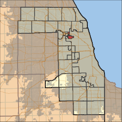 Cook County's location in Illinois
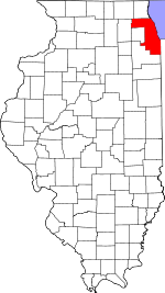
Coordinates: 41°58′06″N 87°49′04″W / 41.96833°N 87.81778°WCoordinates: 41°58′06″N 87°49′04″W / 41.96833°N 87.81778°W Country United States State Illinois County Cook Area – Total 3.67 sq mi (9.51 km2) – Land 3.67 sq mi (9.51 km2) – Water 0 sq mi (0 km2) 0% Elevation 650 ft (198 m) Population (2000) – Total 26,176 – Density 7,132.4/sq mi (2,752.5/km2) Time zone CST (UTC-6) – Summer (DST) CDT (UTC-5) ZIP codes 60068, 60631, 60656, 60706 GNIS feature ID 0429467 Norwood Park Township is one of thirty townships in Cook County, Illinois, USA. As of the 2000 census, its population was 26,176[1].
Contents
Geography
According to the United States Census Bureau, Norwood Park Township covers an area of 3.67 square miles (9.5 km2).
Cities, towns, villages
- Harwood Heights
- Norridge
- Park Ridge (southeast edge)
Adjacent townships
- Leyden Township (southwest)
- Maine Township (northwest)
Cemeteries
The township contains these two cemeteries: Acacia Park and Westlawn Jewish.
Major highways
Political districts
- Illinois' 9th congressional district
- State House District 19
- State House District 20
- State House District 65
- State Senate District 10
- State Senate District 33
References
- "Norwood Park Township, Cook County, Illinois". Geographic Names Information System, U.S. Geological Survey. http://geonames.usgs.gov/pls/gnispublic/f?p=gnispq:3:::NO::P3_FID:0429467. Retrieved 2010-01-10.
- United States Census Bureau 2007 TIGER/Line Shapefiles
- United States National Atlas
External links
Categories:- Townships in Cook County, Illinois


Wikimedia Foundation. 2010.