- Orange Township, Carroll County, Ohio
-
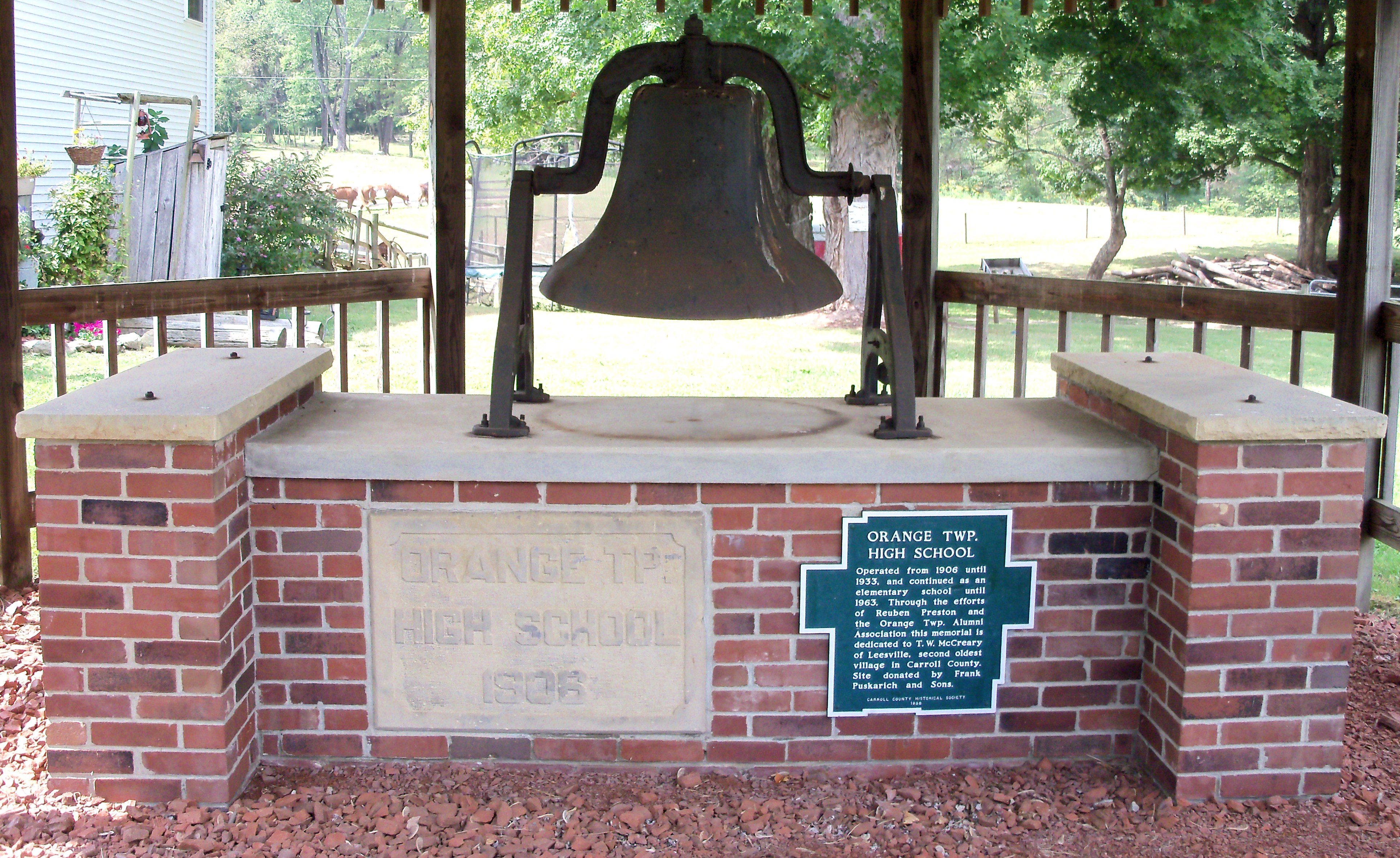
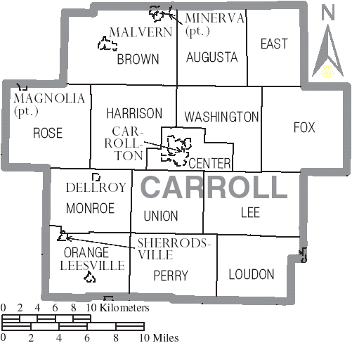
Orange Township, Ohio — Township — The old high school bell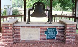 Municipalities and townships of Carroll County.
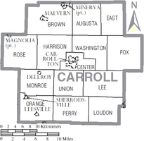
Coordinates: 40°28′29″N 81°13′9″W / 40.47472°N 81.21917°WCoordinates: 40°28′29″N 81°13′9″W / 40.47472°N 81.21917°W Country United States State Ohio County Carroll Area – Total 27.3 sq mi (70.7 km2) – Land 26.2 sq mi (67.9 km2) – Water 1.1 sq mi (2.8 km2) Elevation[1] 928 ft (283 m) Population (2000) – Total 1,258 – Density 48.0/sq mi (18.5/km2) Time zone Eastern (EST) (UTC-5) – Summer (DST) EDT (UTC-4) FIPS code 39-58576[2] GNIS feature ID 1085833[1] Orange Township is one of the fourteen townships of Carroll County, Ohio, United States. The 2000 census found 1,258 people in the township, 806 of whom lived in the unincorporated portions of the township.[3]
Contents
Geography
Located in the southwestern corner of the county, it borders the following townships:
- Monroe Township - north
- Union Township - northeast corner
- Perry Township - east
- Monroe Township, Harrison County - south
- Union Township, Tuscarawas County - southwest
- Warren Township, Tuscarawas County - northwest
Two incorporated villages are located in Orange Township: Leesville in the south, and part of Sherrodsville in the northwest.
The Conotton Creek flows through the township.
Name and history
It is one of six Orange Townships statewide.[4]
Part of Orange Township was originally under the name of One-leg Township, Tuscarawas County (founded March 29, 1809, dissolved with formation of Carroll County).[5] One Leg was an early name for Conotton Creek, named after a one-legged Indian who lived along its banks. The township has part of the original surveyed townships 13 and 14, in range 6 and parts of townships 14 and 15 of range 7 of the Old Seven Ranges. [6][7][8]
Government
Historical populations Census Pop. %± 1840 1,528 — 1850 1,577 3.2% 1860 1,284 −18.6% 1870 1,207 −6.0% 1880 1,327 9.9% 1890 2,705 103.8% 1900 2,200 −18.7% 1910 1,692 −23.1% 1920 1,098 −35.1% 1930 994 −9.5% 1940 956 −3.8% 1950 1,134 18.6% 1960 1,238 9.2% 1970 1,075 −13.2% 1980 1,171 8.9% 1990 1,123 −4.1% 2000 1,258 12.0% 2010 1,339 6.4% [9] The township is governed by a three-member board of trustees, who are elected in November of odd-numbered years to a four-year term beginning on the following January 1. Two are elected in the year after the presidential election and one is elected in the year before it. There is also an elected township fiscal officer,[10] who serves a four-year term beginning on April 1 of the year after the election, which is held in November of the year before the presidential election. Vacancies in the fiscal officership or on the board of trustees are filled by the remaining trustees.
The current office holders and end of their terms are [11][12]
Trustees:
- Jim Romig December 31, 2013,
- Joseph A. Nign December 31, 2013,
- Robert McClain December 31, 2011
Fiscal Officer (Clerk):
- Mary E. Thompson March 31, 2012
Education
Students attend the Conotton Valley Union Local School District.[13]
Beginning in 1837 through most of the 19th century, the New Hagerstown Academy was at the place in the township of the same name [14].40°26′36″N 81°11′11″W / 40.44333°N 81.18639°W
References
- ^ a b "US Board on Geographic Names". United States Geological Survey. 2007-10-25. http://geonames.usgs.gov. Retrieved 2008-01-31.
- ^ "American FactFinder". United States Census Bureau. http://factfinder.census.gov. Retrieved 2008-01-31.
- ^ Carroll County, Ohio — Population by Places Estimates Ohio State University, 2007. Accessed 15 May 2007.
- ^ "Detailed map of Ohio" (PDF). United States Census Bureau. 2000. http://www2.census.gov/geo/maps/general_ref/cousub_outline/cen2k_pgsz/oh_cosub.pdf. Retrieved 2007-02-16.
- ^ Mansfield, J.B. (1884). The History of Tuscarawas County. Warner, Beers & Co. p. 356. http://books.google.com/books?id=5DguAAAAYAAJ&printsec=frontcover&dq=history+tuscarawas+county&ei=18pLS7CwJIbazQS_ieGUDA&cd=1#v=onepage&q=&f=false.
- ^ Eckley, H.J.; Perry, W.T. (1921). History of Carroll and Harrison Counties. The Lewis Publishing Co. pp. 194–195. http://www.heritagepursuit.com/Carroll/Carroll1921Index.htm.
- ^ History of Monroe Township, p.2-3
- ^ Howe, Henry (1907). Historical Collections of Ohio, The Ohio Centennial Edition. The State of Ohio. p. 363. http://books.google.com/books?id=OXIOAAAAIAAJ&printsec=frontcover&dq=henry+howe&ei=Mc1LS_3NM5nAzQT-zImMDA&cd=2#v=onepage&q=&f=false.
- ^ census data: 1840, 1880 : Howe, Henry (1907). Historical Collections of Ohio, The Ohio Centennial Edition. The State of Ohio. p. 359. http://books.google.com/books?id=OXIOAAAAIAAJ&pg=PA359. , 1850 : 1850 page 14 , 1860 : 1860 page 13 , 1870 : 1870 page 24 , 1890,1900 : Hunt, William C. (1901). Population of the United States by states and territories, counties, and minor Civil Divisions, as returned at the Twelfth Census: 1900. United States Census Printing Office. p. 306. http://books.google.com/books?id=Pnk9AAAAYAAJ&pg=PA306. , 1900,1910,1920 : Austin, William Lane; Teele, Ray Palmer (1921). Fourteenth census of the United States, Volume 1. Government Printing Office. p. 561. http://books.google.com/books?id=oei2AAAAIAAJ&pg=PA561. , 1930 : 1930 page 40 , 1940 : 1940 page 83 , 1950 : 1950 page 14 , 1960 : 1960 page 16 , 1970 : 1970 page 124 , 1980 : 1980 & 1990 Census Information, at reference desk, Carroll County District Library , 1990 : 1990 , 2000 : 2000, 2010 : [1]
- ^ §503.24, §505.01, and §507.01 of the Ohio Revised Code. Accessed 4/30/2009.
- ^ Carroll County Website
- ^ http://www.the-review.com/news/advertising Mr. Thrifty 3, Nov. 12, 2009, page 3
- ^ PUC Ohio map of School Districts
- ^ New Hagerstown Academy Historical Marker
External links
Municipalities and communities of Carroll County, Ohio Villages Carrollton | Dellroy | Leesville | Magnolia‡ | Malvern | Minerva‡ | Sherrodsville

Townships Unincorporated
communitiesAugusta | Harlem Springs | Kilgore | Leavittsville | Lindentree | Mechanicstown | Morges | New Harrisburg | Pattersonville | Petersburg | Scroggsfield | Wattsville
Footnotes ‡This populated place also has portions in an adjacent county or counties
Categories:- Townships in Carroll County, Ohio
- Canton–Massillon metropolitan area

Wikimedia Foundation. 2010.