- Morpeth, Ontario
-
Morpeth — Unincorporated community — Coordinates: 42°23′35″N 81°50′44″W / 42.39306°N 81.84556°W Country Canada Province Ontario Municipality Chatham-Kent Time zone EST (UTC-5) - Summer (DST) EDT (UTC-4) Forward sortation area N0P 1X0 Area code(s) 519 and 226 NTS Map 040I05 GNBC Code FDWRD Morpeth is a community in Southern Ontario, Canada that is between Blenheim and St. Thomas on Highway 3 in the municipality of Chatham-Kent. It is located less than two hours away from Windsor.
Contents
History
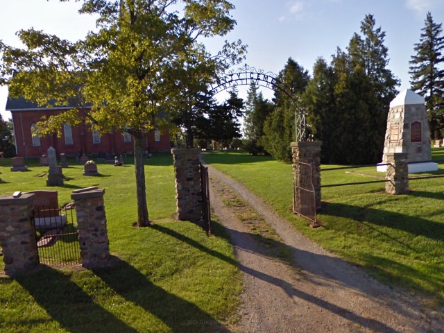
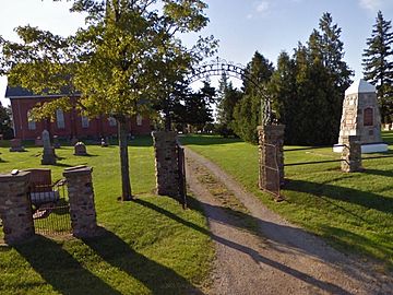 ""The little red church just east of the town" of Morpeth, where Archibald Lampman's father was the minister. Lampman monument on right. Photo by Alan L. Brown, June 2009. Photo used with permission from the website www.ontarioplaques.com.
The community is named after Lord Morpeth, who was once a guest of Col. Thomas Talbot.[1] Morpeth was an area of notable commerce in the 1880s. However when the railroad went through, it instead went through nearby Ridgetown, Ontario, which eventually grew faster than Morpeth.
Archibald Lampman, one of Canada's Confederation Poets, and "generally considered the finest of Canada's late 19th-century poets in English" (Canadian Encyclopedia) was born in Morpeth on November 17, 1861.[2] The Dictionary of Canadian Biography says: "The Morpeth that Lampman knew was a small town set in the rolling farm country of what is now western Ontario, not far from the shores of Lake Erie. The little red church just east of the town, on the Talbot Road, was his father’s charge."[3]
Commerce
Forms of commerce present in the village include an antique store,[4] a zoo,[5] a trailer park, and a marina/campground.[6] To the south, nearby Rondeau Provincial Park provides recreational activities.[7] Morpeth is also an attractive retirement community, with housing available specifically for this need.
Tourism

 Morpeth
Greenview Aviaries, a park and zoo, is located less than a mile east of the village, on the former Highway 3. It attracts visitors from a wide area and has expanded over the years to house many additional animal species, including Big Cats (Tiger, Lions, Jaguars), Wild Game (Buffalo, Elk, Zebras), Primates, Reptiles and Birds.[5]
Morpeth also sees a number of visitors traveling to nearby Rondeau Provincial Park[7] and to Wildwood By the Lake, a family campground.[6] Visitors also stop in Morpeth at Talbot Antiques, Morpeth's one and only antique store, while antiquing.[4]
References
- ^ "Morpeth," Encyclopedia of Canada (Toronto: University Associates, 1948), IV, 338
- ^ Michael Gnarowski, "Lampman, Archibald," Canadian Encyclopedia (Hurtig, 1988), 1169.
- ^ "Lampman, Archibald," Dictionary of Canadian Biography Online. Web, Mar. 22, 2011.
- ^ a b Talbot Antiques, Collectivator.com, Web, Apr. 28, 2011.
- ^ a b "Greenview Aviaries Park and Zoo," Web, Apr. 28, 2011.
- ^ a b Wildwood by the Lake, Web, Apr. 28, 2011.
- ^ a b Rondeau Provincial Park, Web, Apr. 28, 2011.
External links
- Morpeth at Geographical Names of Canada
- Greenview Aviaries Park & Zoo
- Wildwood by the Lake
Coordinates: 42°23′35″N 81°50′44″W / 42.39306°N 81.84556°W
Categories:- Communities in Chatham-Kent, Ontario

Wikimedia Foundation. 2010.