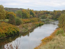
- River Croal
-
River Croal River River Croal at Little LeverCountry England Source - location the confluence of Middle Brook and Deane Church Brook Mouth - location confluence with River Irwell - coordinates 53°33′0″N 2°22′57″W / 53.55°N 2.3825°W Length 10 mi (16 km) The River Croal is a river located in Greater Manchester, England. It is a tributary of the River Irwell.
Rising at the confluence of Middle Brook and Deane Church Brook, it flows eastwards through Bolton, collecting Gilnow Brook and the larger River Tonge at Darcy Lever. Most of the river is culverted through Bolton town centre, running under Knowsley Street; Market Place and Bridge Street. Before 1836 the River Croal formed the boundary between the townships of Great and Little Bolton.
The river's name is derived from the Old English croh and wella, the winding stream. It was possibly originally called the Middlebrook along its entire length as early references mention the Mikelbrok, (mycel and broc), the great stream but not the Croal.[1]
It meets the Irwell at Nob End, Kearsley after a total course of around ten miles.
Tributaries
References
- Notes
- ^ Mills 1976, p. 76
- Bibliography
- Mills, David (1976), The Placenames of Lancashire, Batsford, ISBN 0 7134 5236 6
External links
Ceremonial county of Greater Manchester Statutory City Region - Greater Manchester Combined Authority
- Greater Manchester Statutory City Region
Metropolitan districts Major settlements - Altrincham
- Ashton-in-Makerfield
- Ashton-under-Lyne
- Atherton
- Audenshaw
- Blackley
- Bolton
- Bury
- Cadishead
- Chadderton
- Clifton
- Denton
- Droylsden
- Dukinfield
- Eccles
- Failsworth
- Farnworth
- Golborne
- Heywood
- Hindley
- Horwich
- Hyde
- Irlam
- Kearsley
- Leigh
- Littleborough
- Manchester
- Middleton
- Milnrow
- Mossley
- Oldham
- Partington
- Pendlebury
- Prestwich
- Radcliffe
- Ramsbottom
- Rochdale
- Royton
- Sale
- Salford
- Shaw and Crompton
- Stalybridge
- Stockport
- Stretford
- Swinton
- Tottington
- Tyldesley
- Urmston
- Walkden
- Westhoughton
- Whitefield
- Wigan
- Worsley
See also: List of civil parishes in Greater Manchester
Rivers Topics - Castles
- Churches
- Demography
- Football clubs
- Geography
- Grade I listed buildings
- Grade II* listed buildings
- Museums
- Parliamentary constituencies
- People
- Places
- Schools
- SAMs
- SSSIs
Categories:- Rivers of Greater Manchester
- Rivers of Bolton
- Culverts
- Geography of Bolton
- Greater Manchester geography stubs
Wikimedia Foundation. 2010.

