- Jingzhou
-
For other uses, see Jingzhou (disambiguation).
Jingzhou
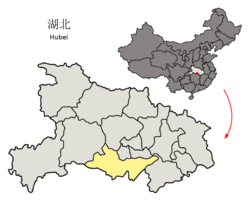
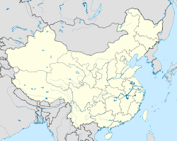
荆州— Prefecture-level city — 荊州市 Location of Jingzhou within Hubei Location in China Coordinates: 30°20′N 112°13′E / 30.333°N 112.217°E Country China Province Hubei Area - Prefecture-level city 14,168 km2 (5,470.3 sq mi) - Urban 1,579 km2 (609.7 sq mi) - Metro 1,579 km2 (609.7 sq mi) Population (2010 Census) - Prefecture-level city 5,691,707 - Density 401.7/km2 (1,040.5/sq mi) - Urban 1,154,086 - Urban density 730.9/km2 (1,893/sq mi) - Metro 1,154,086 - Metro density 730.9/km2 (1,893/sq mi) Time zone China standard time (UTC+8) Website http://www.jingzhou.gov.cn/ Jingzhou (simplified Chinese: 荆州; traditional Chinese: 荊州; pinyin: Jīngzhōu) is a prefecture-level city in Hubei Province, People's Republic of China. The city is located on the banks of the Yangtze River. Its population is 5,691,707 at the 2010 census whom 1,154,086 in the built up area made of 3 urban districts.
Contents
Geography
Jingzhou occupies an area of 14,067 km² with its topography rising from east to west. It is densely covered by a network of waterways, as well as lakes.
Jingzhou is located in the middle reaches of the Yangtze River on the Jianghan Plain. Downstream to its east lies Wuhan, the provincial capital and to to the west the city of Yichang, the Three Gorges, and finally the Chongqing Municipality. Jingmen City, also in Hubei, lies to the north; to its south are Yueyang and Changde, both in Hunan Province.
Climate
Climate data for Jingzhou(1971−2000) Month Jan Feb Mar Apr May Jun Jul Aug Sep Oct Nov Dec Year Average high °C (°F) 8.1
(46.6)10.2
(50.4)14.2
(57.6)21.1
(70.0)26.1
(79.0)29.3
(84.7)32.0
(89.6)32.0
(89.6)27.5
(81.5)22.4
(72.3)16.3
(61.3)10.8
(51.4)20.83
(69.50)Average low °C (°F) 0.9
(33.6)2.8
(37.0)6.6
(43.9)12.9
(55.2)17.9
(64.2)21.8
(71.2)24.7
(76.5)24.4
(75.9)19.6
(67.3)14.0
(57.2)8.0
(46.4)2.9
(37.2)13.04
(55.48)Precipitation mm (inches) 29.6
(1.165)44.8
(1.764)75.4
(2.969)107.6
(4.236)140.8
(5.543)159.9
(6.295)151.2
(5.953)119.9
(4.72)89.3
(3.516)86.8
(3.417)55.2
(2.173)23.4
(0.921)1,083.9
(42.673)Avg. precipitation days (≥ 0.1 mm) 8.2 9.1 12.9 12.8 13.3 13.0 10.5 9.4 9.2 10.6 8.5 6.8 124.3 Source: Weather China Demographics
According to the 2010 Census, the prefecture-level city of Jingzhou has 5,691,707 inhabitants and a population density of 405 inhabitants per km².[1]
Administration
The prefecture-level city of Jingzhou has jurisdiction over two districts, three county-level cities and three counties. The information here presented uses the metric system and data from 2010 Census.
English Name Simplified Traditional Pinyin Area Population Density Jingzhou District 荆州区 荊州區 Jīngzhōu Qū 1,046 553,756 529 Shashi District 沙市区 沙市區 Shāshì Qū 469 498,526 1,063 Jingzhou Development District 荆州开发区 荊州開發區 Jīngzhōu Kāifā Qū 64 101,804 1,591 Songzi City 松滋市 鬆滋市 Sōngzī Shì 2,235 765,911 343 Shishou City 石首市 石首市 Shíshǒu Shì 1,427 577,022 404 Honghu City 洪湖市 洪湖市 Hónghú Shì 2,519 819,446 325 Jiangling County 江陵县 江陵縣 Jiānglíng Xiàn 1,032 331,344 321 Gong'an County 公安县 公安縣 Gōng'ān Xiàn 2,258 881,128 390 Jianli County 监利县 監利縣 Jiānlì Xiàn 3,118 1,162,770 373 History
Jingzhou has been a transportation hub and commodity distribution center for 6,000 years.
The ancient city of Jingzhou is what is now the main urban area of Jiangling County, which is one of the counties within Jingzhou City. Situated in the middle reaches of the Yangtze River, this has been a strategic location of military importance since ancient times.
Ying, within the borders of present day Jingzhou, was the capital of 20 kings over 411 years of the State of Chu during the Spring and Autumn and Warring States Periods of the Zhou Dynasty (1046 BCE - 256 BCE).
The city is said to have been built with earth by Guan Yu in the Three Kingdoms period. During the Southern and Northern Dynasties period, it was the capital of the Western Liang. In the Five Dynasties and Ten Kingdoms Period, it was the capital of the Nanping State.
Sights
Numerous sites have been preserved from the Chu State period, including the ruins of five Chu cities, 73 sites featuring Chu Culture and more than 800 ancient tombs, including those of 18 Chu kings.
There are also historical sites from the Three Kingdoms period, such as the Wulin Battlefield (where the Battle of Red Cliffs took place) and the Huarong Path.
The city walls were rebuilt in 1646 and measure 9 meters in height and 10 meters in depth. The perimeter of the wall extends for 9.3 kilometers. The city walls, city gates, watchtowers, and battlements have been well maintained . Many of the towers on top of the majestic city gates have been damaged or rebuilt, only leaving the Chaozong Tower which was rebuilt in 1838 on the Gongji Gate.
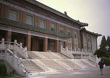
The Jingzhou museum is well-known, most notably for a well-preserved 2,000-year-old male corpse. Also on display are silk and lacquerware from the Warring States Period.
Transportation
- China National Highway 207
- China National Highway 318
- Jingzhou Railway Station on the Jingmen-Shashi and Wuhan-Yichang (under construction) Railways.
See also
References
- ^ (Chinese) Compilation by LianXin website. Data from the Sixth National Population Census of the People's Republic of China
hi shashi'External links
Hubei topics General Geography Cities • Wudang Mountains • Jingshan Mountains • Daba Mountains • Shennongjia • Wu Mountains • Dabie Mountains • Mufu Mountains • Yangtze River • Han River • Three GorgesEducation Culture Cuisine Visitor attractions Jingzhou • Xianling Tomb (in Zhongxiang) • Yellow Crane Tower • Hubei Provincial Museum • Underground Project 131Hubei Province county-level divisions Wuhan: Jiang'an District · Jianghan District · Qiaokou District · Hanyang District · Wuchang District · Qingshan District · Hongshan District · Dongxihu District · Hannan District · Caidian District · Jiangxia District · Huangpi District · Xinzhou District
Huangshi: Huangshigang District · Xisaishan District · Xialu District · Tieshan District · Daye City · Yangxin County
Shiyan: Zhangwan District · Maojian District · Danjiangkou City · Yun County · Zhushan County · Fang County · Yunxi County · Zhuxi County
Jingzhou: Shashi District · Jingzhou District · Shishou · Honghu City · Songzi City · Jiangling County · Gong'an County · Jianli County
Yichang: Xiling District · Wujiagang District · Dianjun District · Xiaoting District · Yiling District · Zhijiang City · Yidu City · Dangyang City · Yuan'an County · Xingshan County · Zigui County · Changyang Autonomous County · Wufeng Autonomous County
Xiangyang: Xiangcheng District · Fancheng District · Xiangzhou District · Laohekou City · Zaoyang City · Yicheng City · Nanzhang County · Gucheng County · Baokang County
Ezhou: Echeng District · Liangzihu District · Huarong District
Jingmen: Dongbao District · Duodao District · Zhongxiang City · Shayang County · Jingshan County
Xiaogan: Xiaonan District · Yingcheng City · Anlu City · Hanchuan City · Xiaochang County · Dawu County · Yunmeng County
Huanggang: Huangzhou District · Macheng City · Wuxue City · Hong'an County · Luotian County · Yingshan County · Xishui County · Qichun County · Huangmei County · Tuanfeng County
Xianning: Xian'an District · Chibi City · Jiayu County · Tongcheng County · Chongyang County · Tongshan County
Suizhou: Zengdu District · Guangshui City · Sui County
Enshi: Enshi City · Lichuan City · Jianshi County · Badong County · Xuan'en County · Xianfeng County · Laifeng County · Hefeng County
Xiantao: (no intermediate County-level divisions, see Administration of Xiantao.)
Tianmen: (no intermediate County-level divisions, see Administration of Tianmen.)
Qianjiang: (no intermediate County-level divisions, see Administration of Qianjiang.)
Shennongjia: (no intermediate County-level divisions, see Administration of Shennongjia.)■ = Sub-provincial city ■ = Prefecture-level city ■ = Autonomous prefectures ■ = Sub-prefecture-level divisionCoordinates: 30°20′04″N 112°13′28″E / 30.33444°N 112.22444°E
Categories:- Cities in Hubei
- Populated places on the Yangtze River
Wikimedia Foundation. 2010.


