- Changyang Tujia Autonomous County
-
Changyang Tujia Autonomous County
长阳土家族自治县— County — Chinese transcription(s) – Chinese – Pinyin Longtanhe Bridge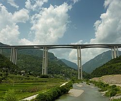
Country China Province Hubei Prefecture Yichang Time zone China Standard (UTC+8) Postal code Changyang Tujia Autonomous County is an autonomous county in Hubei Province, China. It is under the administration of the prefecture-level city of Yichang.
The county is located in the basin of the Qingjiang River, a right tributary of the Yangtze. The river is flanked by mountains on both sides, the tallest of which - the Tianzhu Mountain - is 2,542 m tall. The river is dammed by the Geheyan Dam (located within the county) and the Gaoba Dam (located in the neighboring Yidu County-level City, but flooding some of the Qingjiang River valley within Changyang County as well). The resulting reservoirs provide the main water transportation route throughout much of the county.
Established in 1984 with a surface area of 3,412 square kilometers and a population in 1984 of 399,000 inhabitants, of which 295,000 were Tujia. [1]
Transportation
 Tieluoping bridge, west of Langping town
The new Yichang-Wanzhou Railway crosses the northwestern part of the county, with two stations - Langping and Hejiaping - located near the eponymous towns of the county.
The China National Highway 318, and the newly constructed Shanghai-Chongqing Expressway (G50) run roughly parallel to the railway. Building the expressway in this area required the construction of a number of tunnels and remarkable bridges, such as the Longtanhe Bridge just outside of Langping Town.[2]
References
Hubei Province county-level divisions Wuhan: Jiang'an District · Jianghan District · Qiaokou District · Hanyang District · Wuchang District · Qingshan District · Hongshan District · Dongxihu District · Hannan District · Caidian District · Jiangxia District · Huangpi District · Xinzhou District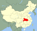 Hubei in China
Huangshi: Huangshigang District · Xisaishan District · Xialu District · Tieshan District · Daye City · Yangxin County
Shiyan: Zhangwan District · Maojian District · Danjiangkou City · Yun County · Zhushan County · Fang County · Yunxi County · Zhuxi County
Jingzhou: Shashi District · Jingzhou District · Shishou · Honghu City · Songzi City · Jiangling County · Gong'an County · Jianli County
Yichang: Xiling District · Wujiagang District · Dianjun District · Xiaoting District · Yiling District · Zhijiang City · Yidu City · Dangyang City · Yuan'an County · Xingshan County · Zigui County · Changyang Autonomous County · Wufeng Autonomous County
Xiangyang: Xiangcheng District · Fancheng District · Xiangzhou District · Laohekou City · Zaoyang City · Yicheng City · Nanzhang County · Gucheng County · Baokang County
Ezhou: Echeng District · Liangzihu District · Huarong District
Jingmen: Dongbao District · Duodao District · Zhongxiang City · Shayang County · Jingshan County
Xiaogan: Xiaonan District · Yingcheng City · Anlu City · Hanchuan City · Xiaochang County · Dawu County · Yunmeng County
Huanggang: Huangzhou District · Macheng City · Wuxue City · Hong'an County · Luotian County · Yingshan County · Xishui County · Qichun County · Huangmei County · Tuanfeng County
Xianning: Xian'an District · Chibi City · Jiayu County · Tongcheng County · Chongyang County · Tongshan County
Suizhou: Zengdu District · Guangshui City · Sui County
Enshi: Enshi City · Lichuan City · Jianshi County · Badong County · Xuan'en County · Xianfeng County · Laifeng County · Hefeng County
Xiantao: (no intermediate County-level divisions, see Administration of Xiantao.)
Tianmen: (no intermediate County-level divisions, see Administration of Tianmen.)
Qianjiang: (no intermediate County-level divisions, see Administration of Qianjiang.)
Shennongjia: (no intermediate County-level divisions, see Administration of Shennongjia.)■ = Sub-provincial city ■ = Prefecture-level city ■ = Autonomous prefectures ■ = Sub-prefecture-level divisionCategories:- County-level divisions of Hubei
- Yichang
- Hubei geography stubs


Wikimedia Foundation. 2010.