- Cehu Silvaniei
-
Cehu Silvaniei — Town — Location of Cehu Silvaniei
Coordinates: 47°25′5″N 23°17′12″E / 47.41806°N 23.28667°ECoordinates: 47°25′5″N 23°17′12″E / 47.41806°N 23.28667°E Country  Romania
County Sălaj County Status Town Government – Mayor András Varga (UDMR) Area – Total 67.77 km2 (26.2 sq mi) Population (2004) – Total 8,468 Time zone EET (UTC+2) – Summer (DST) EEST (UTC+3) Website http://www.primaria-cehusilvaniei.ro  Cehu Silvaniei in Sălaj County
Cehu Silvaniei (Hungarian: Szilágycseh, until 1854 Szilágy-Cseh, meaning "Czechs of Szilágy") is a town in Sălaj County, Transylvania, Romania. Four villages are administered by the town: Horoatu Cehului (Oláhhorvát), Motiş (Mutos), Nadiş (Szilágynádasd) and Ulciug (Völcsök).
Contents
History of the town
The first written mention of the town dates from 1319 under the name Cheevar. In 1405, the city was mentioned under the name Chehy. The Hungarian name of the city referred to a stand of Czech origin.
The town was until 1918 part of the Kingdom of Hungary and specifically of the Principality of Transylvania. In 1529, the voivod István Báthory granted the city the right to govern itself.
After the dissolution of the principality of Transylvania in 1867 and its direct integration into the Austro-Hungarian Empire as part of Hungary (see the Austro-Hungarian Compromise of 1867), the city is attached to the county of Szilágy in 1876. In 1918, during the disintegration of the empire at the end of the First World War, the city became part of the Kingdom of Romania.
From 1940 to 1944 it was annexed by Hungary as a result of the Second Vienna Award. In May 1944, its Jewish community was exterminated by the Nazis during several deportations to Auschwitz.
At the end of the Second World War, the city was incorporated by Romania again.
The city has long been an agricultural center. In 1968, during the country's administrative reorganization, it acquired city status and then industrialization take place (textiles, furniture).
 Adăugați o legendă aici
Demographics
Ethnic groups
At the 2002 census, 49.5% of inhabitants were Hungarians, 47.4% Romanians and 3% Roma.[1]
Religion
48.1% were Romanian Orthodox, 43.6% Reformed, 3.5% Roman Catholic, 2.1% belonged to "another religion", and 0.8% each Greek-Catholic and Baptist.[1]
Historic sites and monuments
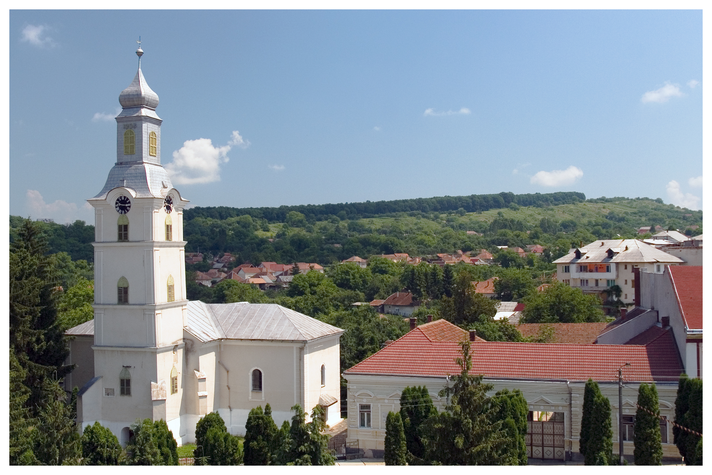
Hungarian Reformed Church of Cehu-Silvaniei - national monument
Probably members of two families, Miklós Drágffy and his wife, and Eufémia Jakcs or their son, Bertalan, later voivod of Transylvania (1493-98)bulit the church somwhere in the middle of the second half of the 15th century. Governor Drágffy János (1525-26) was an important patron of the church: he made some changes on the church in 1519, and had a lombard-patterned renaissance sedile made for it in 1522.
In 1614, due to the generosity of Prépostváry Zsigmond and his wife Széchy Katalin, the rules os the market-town then, the tower at the western facade is bulit, as shown by the escutcheoned memorial tablet on its southern wall. The medieval nave is enlarged in 1801, and then 1905, eith square side-aisles and the interiour gets a classicist proportions. This church is a national monument classified with number SJ-II-m-A-05034.
Jewish cemetery
The Jewish cemetery[2] is located at Cehu Silvaniei, Cloşca Str. no. 8, Sălaj County, 249.1 miles NNW of Bucharest and 34 km from Zalău.
The 1850 Jewish population by census was 63, in 1857 was 66, in 1880 was 206, in 1900 was 369, in 1910 was 517, and in 1930 was 551. In May 1944, the Jews were gathered in the "ghetto (of Nazis)" made into Cehu Silvaniei, then in that from Şimleu Silvaniei and on May 31, June 6, 8 they were deported to Auschwitz. The unlandmarked Orthodox cemetery was established in 19th century. The last known burial was in the 20th century.
The isolated suburban flat land has no sign or marker. Reached via private road, access is open with permission. A fence with a gate that locks surrounds the site. Approximate 1-20 stones are visible, some not in original location with 25%-50% of the stones being toppled or broken. The location of the stones that have been removed from the cemetery is unknown. Vegetation overgrowth in the cemetery is a seasonal problem preventing access. Water drainage is good all year. There are no special sections.
The oldest known gravestone dates from 19th century. The 19th and 20th century marble, granite, sandstone, and limestone boulders, flat and shaped, smoothed and inscribed, carved relief decorated gravestones have Hebrew inscriptions. Some have traces of painting on their surfaces. No known mass graves. The national Jewish community owns the property used for Jewish cemetery only. Adjacent properties are residential. The cemetery maintenance worked on the re-erection of stones, patching broken stones, cleaning stones, and clearing vegetation. Current care involves occasional clearing or cleaning of the cemetery by unpaid individuals. There are no structures.
Notable residents
References
External links
Sălaj County, Romania Cities 
Towns Şimleu Silvaniei · Jibou · Cehu Silvaniei
Communes Agrij · Almaşu · Băbeni · Bălan · Bănişor · Benesat · Bobota · Bocşa · Boghiş · Buciumi · Camăr · Carastelec · Chieşd · Cizer · Coşeiu · Crasna · Creaca · Crişeni · Cristolţ · Cuzăplac · Dobrin · Dragu · Fildu de Jos · Gâlgău · Gârbou · Halmăşd · Hereclean · Hida · Horoatu Crasnei · Ileanda · Ip · Letca · Lozna · Măerişte · Marca · Meseşenii de Jos · Mirşid · Năpradea · Nuşfalău · Pericei · Plopiş · Poiana Blenchii · Românaşi · Rus · Sâg · Sălăţig · Şamşud · Sânmihaiu Almaşului · Sărmăşag · Şimişna · Someş-Odorhei · Surduc · Treznea · Valcău de Jos · Vârşolţ · Zalha · Zimbor
Categories:- Populated places in Sălaj County
- Towns in Romania
- Shtetls
- Czech communities in Romania
- Croatian communities
Wikimedia Foundation. 2010.