- Carastelec
-
Carastelec — Commune — 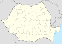
 Carastelec
Coordinates: 47°18′N 22°42′E / 47.3°N 22.7°E Country  Romania
County Sălaj County Population (2002)[1] 1,163 Time zone EET (UTC+2) – Summer (DST) EEST (UTC+3) Carastelec (Hungarian: Kárásztelek) is a commune located in Sălaj County, Romania. It is composed of two villages, Carastelec and Dumuslău (Szilágydomoszló).
At the 2002 census, 90.1% of inhabitants were Hungarians and 9.2% Romanians. 84.2% were Roman Catholic, 9.3% Romanian Orthodox, 3.4% Pentecostal and 2.8% Reformed.
Sălaj County, Romania Cities Zalău (county seat)
Towns Communes Agrij · Almaşu · Băbeni · Bălan · Bănişor · Benesat · Bobota · Bocşa · Boghiş · Buciumi · Camăr · Carastelec · Chieşd · Cizer · Coşeiu · Crasna · Creaca · Crişeni · Cristolţ · Cuzăplac · Dobrin · Dragu · Fildu de Jos · Gâlgău · Gârbou · Halmăşd · Hereclean · Hida · Horoatu Crasnei · Ileanda · Ip · Letca · Lozna · Măerişte · Marca · Meseşenii de Jos · Mirşid · Năpradea · Nuşfalău · Pericei · Plopiş · Poiana Blenchii · Românaşi · Rus · Sâg · Sălăţig · Şamşud · Sânmihaiu Almaşului · Sărmăşag · Şimişna · Someş-Odorhei · Surduc · Treznea · Valcău de Jos · Vârşolţ · Zalha · Zimbor
Coordinates: 47°18′N 22°42′E / 47.3°N 22.7°E
References
- ^ Romanian census data, 2002; retrieved on March 1, 2010
Categories:- Communes in Sălaj County
- Sălaj County geography stubs

Wikimedia Foundation. 2010.