- River Poulter
-
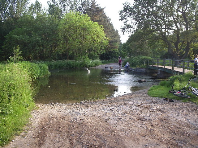
River Poulter River 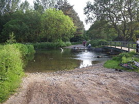 The ford at Crookford, where a track crosses the Poulter
Country England County Nottinghamshire Source - location Scarcliffe Mouth River Idle - location Elkesley The River Poulter is a tributary river of the River Idle in Nottinghamshire, England, which rises near Scarcliffe in Derbyshire. It has supplied power for a number of mills along its route, most of which are now gone, although the mill ponds remain, and Cuckney mill building is still used as a primary school. The river has been dammed in order to create several lakes for the Dukeries estates of Welbeck Abbey and Clumber House now the National Trust property of Clumber Park. The ornamental Gouldsmeadow Lake, Shrubbery Lake and Great Lake on the Welbeck estate are supplied by a tributary of the Poulter, while Carburton Forge Dam and Carburton Dam were built to power a forge and a mill. Clumber Lake, consisting of an upper and lower lake, which is spanned by a Grade II listed ornamental bridge, is part of the Clumber estate, and has suffered from subsidence.
After the parklands, the river flows eastwards past the village of Elkesley, to join the River Idle just outside the village and close to the A1 road. The water quality of the river is good, with most indexes showing that the river is not far from being unpolluted. This enables it to support populations of fish, while the lakes provide significant habitat for large numbers of birds.
Contents
Course
The river Poulter rises at a spring to the south west of Scarcliffe in Derbyshire, close to the 520-foot (160 m) contour, and skirts around the southern edge of the village, before flowing in a north-easterly direction towards Nether Langwith.[1] At the western edge of Langwith, it passes under the abandoned track of the railway which served Langwith Colliery, and then skirts around a modern fish farm. Owl Sick, a stream which rises at Owl Spring in Scarcliffe Park joins it near the village, and is itself joined by a stream which rises near Whaley Hall Farm, and flows in a south-easterly direction through Whaley and the Poulter Country Park.[2] The Country Park was once the location of the waste tips from Langwith Colliery, which closed in 1978. By 1987, most of the site had been cleared, although one of the shafts was retained, as water continued to be pumped from the pit into the river, in order to keep the neighbouring Creswell mine drained. The waste tips were then landscaped in 1988 to form the country park.[3]
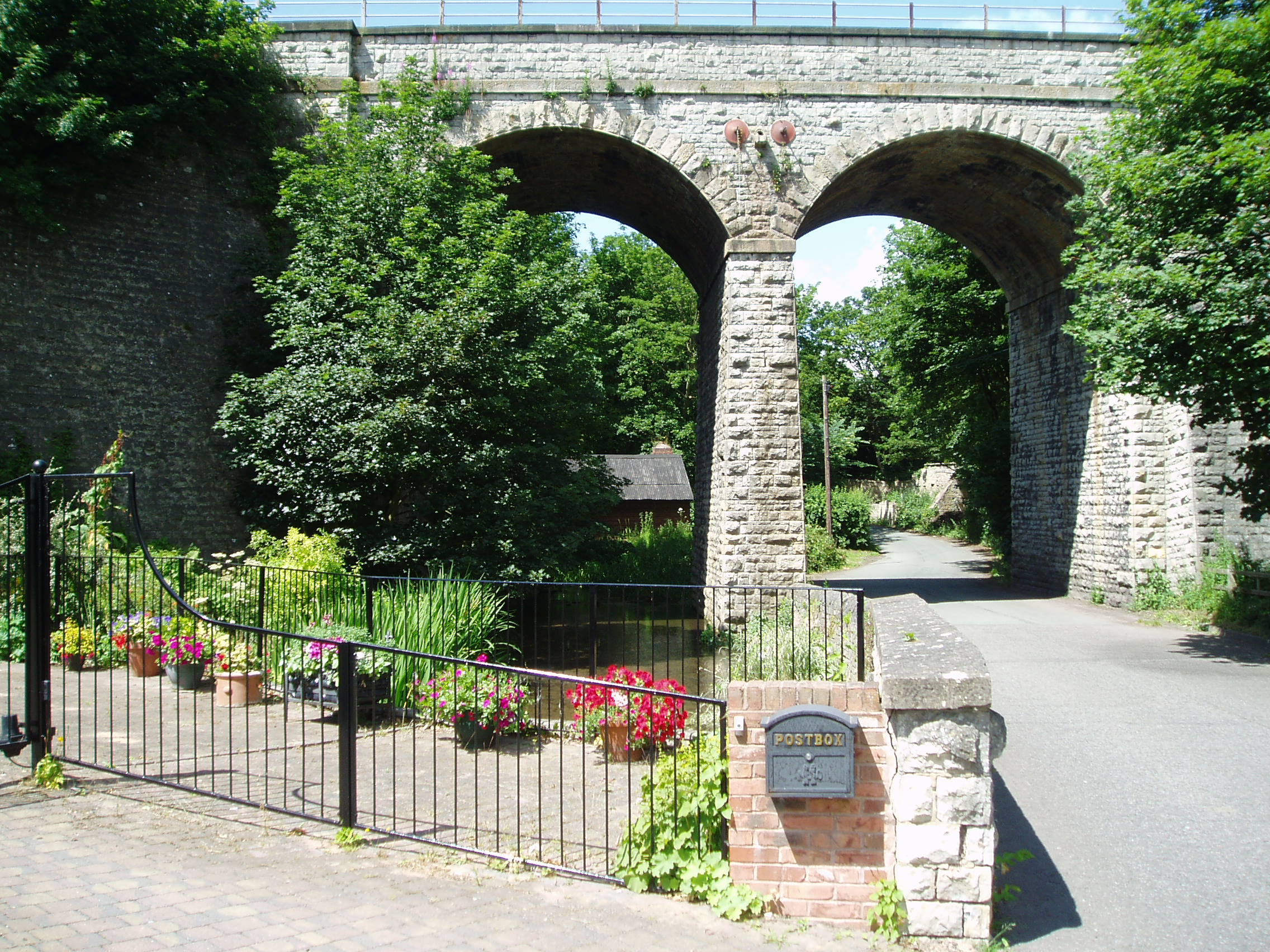
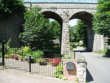 The Langwith Viaduct carries the Robin Hood Line over the river at Langwith. Through the arch is the old pumphouse, which once supplied water to Langwith Colliery.
The combined streams flow into the millpond which supplied Scarcliffe Mill, one of four mills known to have existed along this stretch. Records from Newstead Priory indicate that there was a mill here in 1432, and it was marked on maps of the late 19th century. By 1938 the last mill was no longer in use, and the building was demolished in the 1960s. The mill pond has become silted as a result of the poor condition of the dam and sluice, but could form a central part of a conservation area based on Apsley Grange, a large building on the opposite side of the road.[4] Below the mill site, a small brick building once held pumps which were used to regulate the levels in the river, and to pump water to Langwith Colliery. Next, the river passes through one arch of an impressive two-arched viaduct which was built in the 1870s by the Midland Railway. Although passenger traffic ceased in 1964, as part of the Beeching cuts, the line remained open for goods trains, and became part of the Robin Hood Line from Worksop to Nottingham in 1998.[4] The other arch of the viaduct crosses the Whaley Thorns road, under which the river flows immediately afterwards.
Passing through Langwith, the river splits into two channels, which pass either side of some houses and join up again at a green open space, at a location where a stone sign indicates that this was the site of a sheep dip in 1896. The next of a series of lakes, called "The Lake", and covering an area of 5.4 acres (2.2 ha),[5] lies just to the east of Nether Langwith, beyond which the flow is augmented by the treated output from Langwith Sewage Treatment Works.
Langwith Mill House follows, marking the location of a cotton mill built in 1786. The building had four storeys and was one of the largest of its type in the region. Cotton milling stopped in 1848, and the mill found a new use as a corn mill from 1886. The building still stands, but is in a poor state of repair, and is on the Buildings at Risk Register. The mill house is a Grade II Listed building,[6] and housed a restaurant for a time, but is now empty. Soon the river splits, the northern channel dropping down, while the southern artificial channel maintains its level as it supplied the first of two mills at Cuckney. There have been mills here for several centuries, for a cotton mill was destroyed by fire in 1792. A lake called Cuckney Dam, covering 8.2 acres (3.3 ha),[5] provided the water to power its replacement, which ceased operation on 12 July 1844. After the machinery had been removed, the Duke of Portland turned the building into a National School.[7] The mill building remains in use as part of Cuckney Primary School, and the weir and sluices have been retained.[8] The drop in level of some 13 feet (4.0 m) between the mill pond and the river beyond has enabled the school to harness the river to generate electricity. The 7 kW crossflow turbine[9] which generates a significant proportion of the energy used by the school,[10] was funded by a grant from Powergen's Green Plan fund[11] and a Clear Skies grant.
Flowing around the northern edge of Cuckney, the river reaches the second corn mill which was situated to the east of the village. The mill building has been demolished, but again the sluices and weir are still visible.
Welbeck Lakes
Beyond the mill site, there are two channels, the western one at the level of the mill pond, and the eastern one at a lower level. Both channels head towards the first of the ornamental lakes which are supplied by the river. At this point, the river has dropped some 360 feet (110 m) from its source. Welbeck Great Lake is part of the Welbeck estate, which was owned by the Dukes of Portland, and is now owned by the Bentinck family. The Millwood Brook flows into Gouldsmeadow Lake and through Shrubbery Lake, before joining the Great Lake. In the 1760s, the Duke employed the architect and civil engineer Robert Mylne to construct a three arched bridge, which had to be both functional and beautiful. Mylne experienced problems with the piers moving, which resulted in the central 90-foot (27 m) arch collapsing in February 1768, after which Mylne was sacked.[12] In the 1840s, the Fifth Duke, who went on to build an underground ballroom and tunnels on the estate, employed the engineer William Tierney Clark to construct a suspension bridge. The resident engineer for the project was Bland William Croker, who had assisted Clark with the construction of the Szechenyi suspension bridge in Budapest.[13] The western channel of the Poulter flows through a culvert into the Great Lake, while the lower eastern channel flows through a culvert into Carburton Forge Dam.
Beyond the lake, a weir with a track over it drops the level to Carburton Forge Dam, built to provide power for a forge. 10 acres (4.0 ha) of land were leased to John Wheeler of Worcester in 1695 by the Duke, on which he was empowered to build the forge, a dam pool and floodgates. Deeds held by the Nottinghamshire Archive Service record an agreement between Wheeler and the Duke to pay compensation annually as a result of the stream supplying the forge flooding the Duke's land.[14] The forge flourished until the 1770s, with a writer called Pococke describing how "the pigs [of iron] were brought from Derbyshire to be melted into bars for use" in 1751. The fifth Duke later removed all traces of the forge.[15] Beyond Carburton Forge Dam, another weir drops the level again to Carburton Dam. A "water corn mill, walke mill or fulling mill" is known to have been here in 1678, as it is mentioned in a lease agreement.[16] The five Welbeck lakes cover a total area of 151 acres (61 ha).[5] Again there are two channels below the lake, the main southern channel being at a lower level than the northern one. Both cross under the B6034 Worksop to Ollerton road, and leave the Welbeck estate.
Clumber Lake
Both then pass under the road which serves the tiny hamlet of Carburton, with the upper channel, which is called Flood Dyke, ending in a field. From here there is a sluice and the water flows through a culvert into an open section where there is another sluice, and a second culvert to rejoin the lower channel. The upper sluice is marked "sluices" on the 1898 map,[17] and also fed a large fish pond to the east of the channel. The fish pond was disused by 1919, when it was marked as swampy ground.[18] The lower channel flows past a building marked "Wheel House (pumping station)" in 1898.[17] It then continues under Carburton bridge to supply Clumber Lake, which was part of the Clumber estate of the Dukes of Newcastle, but has been owned by the National Trust since 1945. The Clumber estate was described in the 18th century as "A black heath full of rabbits, having a narrow river running through it, with a small boggy close or two."[19] This changed in 1772, when the Second Duke of Newcastle started construction of Clumber Lake, to complement his new house. A dam was built at the bottom end of the estate, the river bed was excavated to create a wide expanse of water, and an ornamental bridge was erected at the western end. The project took 15 years to complete, and cost £6,612.[20] The bridge, which consists of three unequal arches with balustrading along the top, was designed by Stephen Wright, and is some 230 feet (70 m) long. It is a Grade II* listed structure.[21]
Improvements to the lake were carried out in 1786 under the direction of Mr Marson, who was the estate manager.[22] The 4th Duke of Newcastle built a cascade just below the bridge in 1823,[23] and a new one in 1835, when the work was completed by Mr Grey. The Duke described the construction as "ingenious and well managed."[24] There were problems in 1842, when the culvert feeding water from the lake to an engine which supplied water to the house was found to be clogged with fine tree roots.[25] In the spring of 1845, 1846 and 1847, the Duke drained the lake in order to make it wider and to improve the banks, which he felt looked "neither natural nor handsome" in places.[26]
Below the ornamental bridge, a weir drops the level of the lake by around 3.3 feet (1.0 m). In Victorian times, the park had two independent water supply systems, one supplying the house and its associated buildings, with the other supplying the farm and the village of Hodsock. Around 500 people lived on the estate at the time. The house supply came from an Artesian well, and was pumped to an underground reservoir, which held 60,000 imperial gallons (270 m3) of water, from where it travelled 0.5 miles (0.80 km) by gravity. The difference in levels of the two parts of the lake was sufficient to power a Gilbert Gilkes and Gordon turbine, which drove the pump. The two systems became one in 1931, when a new treble ram vertical pump was installed, which was driven by the existing turbine. Pumping is now normally done by electric pumps, but the original machinery is still in place, and was for a number of years used to supply the park with water if there was a power cut.[27]
More recently, the lake which covers some 79 acres (32 ha)[5] has been affected by subsidence caused by coal mining below it, and UK Coal funded remedial work in the 1980s and in 2004. The lowering of the water level during this work revealed the charred remains of the Lincoln, a one-third scale naval frigate which the Duke bought in 1871, and which was destroyed by fire in the 1940s.[28] The river leaves the lake by a weir and cascade near Hardwick village, beyond which there is a ford, and another weir a little further beyond that drops the level again, before the river passes under West Bridge on the A614 Worksop to Ollerton road. Most of the rest of the route is through woodland, in the middle of which a ford crosses the river near Crookford farm. Finally, the river is crossed by the B6387 Ollerton to Gamston road, and the A1 road near Gamston Airport, before joining the River Idle just downstream of the point where the River Maun and River Meden meet, and the Idle begins.
Hydrology
The source of the river Poulter is in a region where the underlying geology is an extensive water-bearing porous rock structure called the Magnesian Limestone aquifer. Magnesian limestone is so named because if contains quantities of the mineral Dolomite, which is rich in Magnesium. Where this rock reaches the surface, springs often occur, and the Poulter starts at such a spring. Further to the east, the Magnesian Limestone is covered by another layer of porous rock called the Triassic Sherwood Sandstone aquifer, which is the major geological component of the area. Continuing eastwards, both are then covered by a layer of Mercia mudstone. The groundwater levels in these aquifers affect whether they supply water to the river system, or take water from it, and levels are lower than they have historically been, as a result of the extraction of groundwater, particularly for public water supply, and by fracturing of the aquifers as a result of subsidence caused by deep coal mining.[29]
Above Cuckney, where the Environment Agency have a gauging station which records flows in the river, the catchment for the River Poulter covers some 12 square miles (31 km2),[30] which has an average annual rainfall of 24 inches (610 mm) (based on figures from 1961 to 1990). About a third of this finds its way into the river.[29] Water quality is good. The Environment Agency use a six stage rating scale, from 'A' to 'F', called the General Quality Assessment, to classify rivers. 'A' on the GQA is the best quality of water, while 'F' is the poorest. Factors which affect the quality are levels of ammonia, levels of dissolved oxygen and the Biochemical oxygen demand (BOD), which measures the amount of dissolved oxygen needed by organisms to break down organic matter in the water. These factors are generally worse when the water is discharged from sewage treatment processes, and tend to be worse in summer, when such discharges make up a greater proportion of the total flow in the river. The upper Poulter, above Welbeck Lake, is rated at 'B' on the GQA scale, despite the fact that the flows are augmented by the outflow from Langwith Sewage Treatment Works, which contributes around 1.2 Ml/d (megalitres per day) and by water from Langwith fish farm, which can be up to 0.9 Ml/d, but which is seasonal in nature.[31]
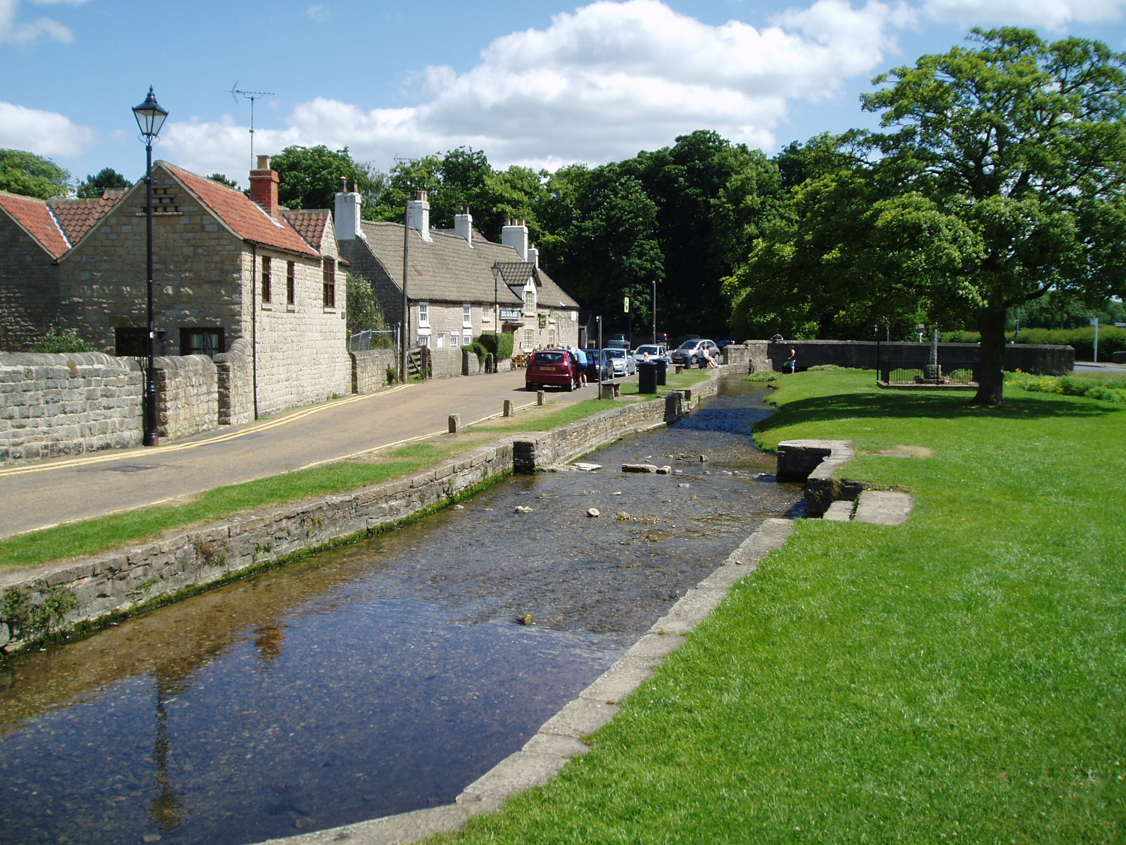
 The river at Langwith
The quality of the water remains good through the length of the river. Figures for the final section before it joins the River Idle show that the levels of ammonia and dissolved oxygen are those which would be expected in a natural ecosystem. Between 1991 and 2006, the BOD has been reduced by more than 50 percent, but there is still room for improvement. Levels of phosphates and nitrates, which are affected by agricultural activity, are quite high, but some improvements have occurred. Water quality is also measured by two biological indexes. These are NTAXA, which relates to the total number of invertebrate species found in samples of the water, and ASPT, (the Average Score Per Taxon), calculated from the numbers of specific invertebrates which are graded according to their sensitivity to organic pollution. The assessment for the years 2004 to 2006 rated the final section as grade A (very good) on the first index, and grade B (good) on the second. This indicates that the water is not far short from unpolluted.[32]
Flora and Fauna
The upper reaches of the river are diverse, both in terms of their physical nature and their ecological importance. They include an area of wet woodland, which provides a rich habitat for many species.[33] The quality of the water in the river is sufficient to support various fish species. The river above Welbeck Lake provides habitat for a significant population of wild brown trout. The size of the lakes results in the water moving much more slowly, and they support populations of cyprinids, pike and eels, which thrive in water which is relatively static. The lower reaches of the river are used for spawning by fish which inhabit the River Idle.[31]
The lakes provide habitat for large numbers of birds. Clumber lake is fringed by alder, sallow and ash trees, with some sedge marsh. It was one of the first sites in the country used by gadwall for breeding, and also has a population of goosander in the winter. Hobbys frequent the reed bed below Clumber Dam in August and September, where they hunt swallows and martins. The upper lake is fringed by oak, yew, beech and scots pine trees, and provides habitat for willow tits and woodpeckers, with blackcaps visiting in the summer. Mandarin ducks also visit occasionally.[34]
Points of Interest
Point Coordinates
(Links to map resources)OS Grid Ref Notes Source 53°12′35″N 1°16′14″W / 53.2097°N 1.2705°W SK488683 Spring near Scarcliffe Langwith Viaduct 53°13′36″N 1°12′41″W / 53.2268°N 1.2113°W SK527702 site of Scarcliffe mill Langwith mill 53°13′39″N 1°10′56″W / 53.2274°N 1.1821°W SK547703 Cuckney School 53°14′00″N 1°09′44″W / 53.2332°N 1.1621°W SK560710 Former mill Welbeck Great Lake 53°14′44″N 1°07′49″W / 53.2455°N 1.1303°W SK581724 weir Carburton Dam 53°14′45″N 1°06′06″W / 53.2458°N 1.1017°W SK600724 sluice Clumber bridge 53°15′28″N 1°04′15″W / 53.2578°N 1.0708°W SK620738 Hardwick ford 53°16′11″N 1°02′23″W / 53.2698°N 1.0396°W SK641751 Crookford 53°16′11″N 0°59′41″W / 53.2697°N 0.9946°W SK671752 Mouth 53°16′16″N 0°57′02″W / 53.2710°N 0.9505°W SK700754 Jn with River Idle Bibliography
- Cross-Rudkin, Peter et. al. (2008). A Biographical Dictionary of Civil Engineers in Great Britain and Ireland: Vol 2: 1830 to 1890. Thomas Telford. ISBN 978-0-7277-3504-1.
- Environment Agency (2006). The Idle and Torne Catchment Abstraction Management Strategy. Environment Agency.
- Firth, J. B. (1916). "Highways and Byways in Nottinghamshire". Macmillan. http://www.ebooksread.com/authors-eng/j-b-john-benjamin-firth/highways-and-byways-in-nottinghamshire-ala/page-22-highways-and-byways-in-nottinghamshire-ala.shtml. Retrieved 2010-07-03.
- Fletcher, John, ed (2001). Where Truth Abides - Diaries of the 4th Duke of Newcastle-under-Lyme (1822-1850). Country Books (for the National Trust). ISBN 1-898941-57-2.
- Innes-Smith, Robert (1984). The Dukeries and Sherwood Forest. English Life Publications Ltd. ISBN 0-85101-203-5.
- Skempton, Sir Alec et. al. (2002). A Biographical Dictionary of Civil Engineers in Great Britain and Ireland: Vol 1: 1500 to 1830. Thomas Telford. ISBN 0-7277-2939-X.
References
- ^ Ordnance Survey, 1:25000 map, Sheet 269
- ^ Ordnance Survey, 1:25000 map, Sheet 270, ISBN 0-319-23818-0
- ^ Langwith Community Website, History, accessed 2010-06-23
- ^ a b Bolsover District Council, Apsley Grange Conservation Area, Appraisal and Management Plan, October 2008, accessed 2010-07-03
- ^ a b c d Habitat Action Plan, (2008), Eric Palmer, Notts Wildlife Trust, accessed 2010-06-27
- ^ Bassetlaw District Council, Buildings at Risk, accessed 2010-06-23
- ^ Genuki - White's Directory (1853), Entry for Cuckney, accessed 2010-06-21
- ^ Cuckney CofE Primary School, History, accessed 2010-06-21
- ^ Derwent Hydroelectric Power, Project List, accessed 2010-06-24
- ^ Cuckney CofE Primary School, Prospectus, accessed 2010-06-24
- ^ Micropower newsletter, January 2006, p.4, accessed 2010-06-24
- ^ Skempton 2002, p. 467
- ^ Cross-Rudkin 2008, p. 210
- ^ Nottinghamshire Archives, Agreement 157 DD/P/5/76, dated 5 June 1696, accessed 2010-07-03
- ^ Firth 1916, p. 22
- ^ Nottinghamshire Archives, Agreement 157 DD/P/5/62, dated 1/2 Oct.1678, accessed 2010-07-03
- ^ a b Ordnance Survey, 1:2,500 map, 1898
- ^ Ordnance Survey, 1:2,500 map, 1919
- ^ Innes-Smith 1984, p. 14
- ^ The National Trust, Walks, Clumber, Nottinghamshire, accessed 2010-06-21
- ^ Details from listed building database (241269 ) Clumber Bridge . Images of England. English Heritage. Retrieved 2010-06-27.
- ^ Bassetlaw District Council, Clumber Park, accessed 2010-06-27
- ^ Fletcher 2001, p. 26
- ^ Fletcher 2001, p. 151
- ^ Fletcher 2001, p. 254
- ^ Fletcher 2001, pp. 285, 287, 294, 300
- ^ National Trust, Clumber Park, Interpretation Board by pumping station
- ^ Worksop Guardian, Where has all the water gone?, 10 September 2004
- ^ a b Environment Agency 2006, pp. 31–33
- ^ Environment Agency 2006, p. 29
- ^ a b Environment Agency 2006, pp. 35–36
- ^ Highways Agency, A1 Elkesley Junction Improvements, Assessment Report, (July 2008), accessed 2010-07-04
- ^ Environment Agency 2006, p. 16
- ^ Nottinghamshire Birds, Clumber Park, accessed 2010-07-05
 Rivers and Watercourses of Nottinghamshire
Rivers Devon · Erewash · Farleys Brook · Greet · Idle · Kingston Brook · Leen · Maun · Meden · Poulter · Rainworth Water · Ryton · Soar · Trent · Vicar Water · Whyburn
Categories:- Rivers of Nottinghamshire
Wikimedia Foundation. 2010.