- Amador County Airport
-
Amador County Airport
Westover Field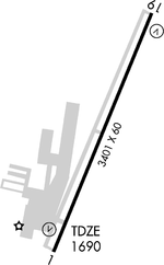
IATA: none – ICAO: KJAQ – FAA LID: JAQ Summary Airport type Public Owner County of Amador Serves Jackson, California Elevation AMSL 1,690 ft / 515 m Coordinates 38°22′36″N 120°47′38″W / 38.37667°N 120.79389°W Runways Direction Length Surface ft m 1/19 3,401 1,037 Asphalt Statistics (1997) Aircraft operations 25,000 Based aircraft 89 Source: Federal Aviation Administration[1] Amador County Airport (ICAO: KJAQ, FAA LID: JAQ, formerly O70), also known as Westover Field, is a county-owned public-use airport in Amador County, California, United States. It is located two nautical miles (3.7 km) northwest of the central business district of Jackson, California.[1] The airport is mostly used for general aviation.
Although many U.S. airports use the same three-letter location identifier for the FAA and IATA, this facility is assigned JAQ by the FAA but has no designation from the IATA[2] (which assigned JAQ to Jacquinot Bay Airport in Papua New Guinea[3]).
Facilities and aircraft
Amador County Airport covers an area of 110 acres (45 ha) at an elevation of 1,690 feet (515 m) above mean sea level. It has one runway designated 1/19 with an asphalt surface measuring 3,401 by 60 feet (1,037 x 18 m).[1]
For the 12-month period ending October 1, 1997, the airport had 25,000 aircraft operations, an average of 68 per day: 99% general aviation, <1% air taxi, and <1% military. At that time there were 89 aircraft based at this airport: 88% single-engine, 5% multi-engine, 3% helicopter and 5% ultralight.[1]
References
- ^ a b c d FAA Airport Master Record for JAQ (Form 5010 PDF). Federal Aviation Administration. Effective 29 July 2010.
- ^ "Amador County Airport (ICAO: KJAQ, FAA: JAQ)". Great Circle Mapper. http://www.gcmap.com/airport/KJAQ. Retrieved 5 August 2010.
- ^ "Jacquinot Bay Airport (IATA: JAQ)". Great Circle Mapper. http://www.gcmap.com/airport/JAQ. Retrieved 5 August 2010.
External links
- Aerial image as of 16 August 1998 from USGS The National Map
- FAA Terminal Procedures for JAQ, effective 20 October 2011
- Resources for this airport:
- AirNav airport information for JAQ
- FlightAware airport information and live flight tracker
- SkyVector aeronautical chart for JAQ
Categories:- Airports in California
- Buildings and structures in Amador County, California
- Transportation in Amador County, California

Wikimedia Foundation. 2010.