- Michigan Basin
-
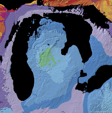
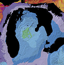 Geologic map of the Michigan Basin
The Michigan Basin is a geologic basin centered on the Lower Peninsula of the US state of Michigan. The feature is represented by a nearly circular pattern of geologic sedimentary strata in the area with a nearly uniform structural dip toward the center of the peninsula.
The basin is centered in Gladwin County where the Precambrian basement rocks are 16,000 feet (4,900 m) deep. Around the margins, such as under Mackinaw City, Michigan, the Precambrian surface is around 4,000 feet (1,200 m) down. This 4,000-foot (1,200 m) contour on the bedrock clips the northern part of the lower peninsula and continues under Lake Michigan along the west. It crosses the southern counties of Michigan and continues on to the north beneath Lake Huron.
On the north in the Canadian Shield, which includes the western part of Michigan's Upper Peninsula, Precambrian rocks are exposed at the surface. The eastern margins of Wisconsin along Green Bay are along the margins of the basin, while Precambrian rocks crop out to the west in central Wisconsin. The northeastern margin of Illinois around Chicago are on the southwestern margin of the basin. The southeast striking Kankakee Arch continuation of the Cincinnati Arch forms the southwest boundary of the basin underlying northeastern Illinois and northern Indiana. To the east, the Findlay Arch forms the southeast margin of the basin as it strikes to the northeast across northwestern Ohio, under the bed of Lake Erie and on as the Algonquin Arch through the southwestern prong of Ontario. The Wisconsin Arch forms the western boundary of the basin.
The rocks of the basin include Cambrian-Ordovician sandstones and carbonate rocks around the margins and at depth. Above or basinward are found the Silurian-Devonian dolostones and limestones with Carboniferous (Mississippian and Pennsylvanian) strata filling the center. A relatively thin veneer of Jurassic sediments are found in the center of the basin at the surface.
The basin appears to have subsided concurrently with basin filling as the sediments within the basin are all relatively shallow water sediments, many of which are richly fossiliferous. The location was located on a geologically passive portion of crust. The development of the basin and the surrounding arches were likely affected by the tectonic activity of the long term Appalachian orogeny several hundred miles to the south and east.
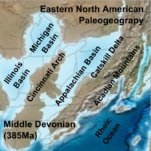 Paleogeographic reconstruction showing the Michigan Basin area during the Middle Devonian period.[1]
Within the Precambrian rocks beneath and just west of the center of the basin lies a generally north to northwest trending linear feature that appears to be an ancient rift in the Earth's crust. This rift appears to be contiguous with the rift zone under Lake Superior. This, the Midcontinent Rift System, turns west under Lake Superior and then southwest through southern Minnesota, central and western Iowa and on through southeastern Nebraska and into eastern Kansas.
Natural Resources
The rocks of the Michigan Basin are the source of commercial quantities of petroleum. The most actively drilled-for source of natural gas in recent years has been shale gas from the Devonian Antrim Shale in the northern part of the basin.
Gypsum has been mined from rocks in the basin. Halite (rock salt) occurs in beds of the Salina Formation (Silurian) and the Detroit River Group (Devonian). The Detroit salt mine has mined rock salt from beneath the Detroit metropolitan area since 1906.[2] Brine recovered from wells in the Michigan basin has been used as a commercial source of potassium salts, bromine, iodine, calcium chloride, and magnesium salts.[3]
References
- ^ Blakey, Ron. "Paleogeography and Geologic Evolution of North America". Global Plate Tectonics and Paleogeography. Northern Arizona University. http://jan.ucc.nau.edu/rcb7/nam.html. Retrieved 2008-07-04.
- ^ E.Z. Manos, "Detroit salt mine-past and future", Mining Engineering, Feb. 2003, p.15-19.
- ^ George I. Smith and others (1973) Evaporites and brines, in United States Mineral Resources, US Geological Survey, Professional Paper 820, p.197-216.
External links
Categories:- Geologic provinces of the United States
- Sedimentary basins of North America
- Structural geology
- Geology of Michigan
- Geology of Illinois
- Geology of Ohio
- Geology of Wisconsin

Wikimedia Foundation. 2010.