- Dalkey Quarry
-
 Dalkey Quarry
Dalkey Quarry is a disused granite quarry located in the Dublin suburb of Dalkey. It was used for quarrying during the 19th century, and is now part of Killiney Hill Park, a public park. It is one of Ireland's most significant rock-climbing crags.
Contents
History
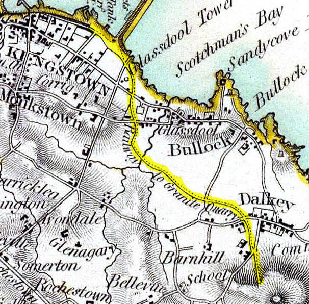
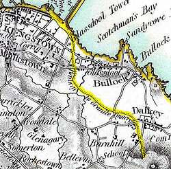 Route of quarry tramway, 1837
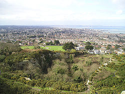 Looking northwards over the Upper Tier and West Valley
In 1815-1817, quarrying started on Dalkey Hill in order to supply granite for the construction of the new harbour pier at nearby Dún Laoghaire, as well as for the construction of the South Bull Wall (part of the outer defences of Dublin Harbour) and as flagstone for Dublin streets. In the 1840s, stone from the quarry was exported to Newfoundland by Bishop Michael Fleming and used in the construction of the Basilica of St. John the Baptist in St. John's[1]. The quarry was connected to Dún Laoghaire by a light railway, part of whose alignment was used to build the Dalkey Atmospheric Railway. The remaining part of the route is now a public footpath known as The Metals, and much of the original granite paving survives. Many of the current houses on nearby Ardbrugh Road may have been originally built as quarry staff cottages, though most quarrymen originally squatted or lived in primitive tents. Quarrying continued sporadically thereafter, finally ending in 1917.
In 1914 most of the land was added to the existing Killiney Hill Park, opening it to the public.
In 1998, the local authority which owns the land drew up proposals to turn the quarry's West Valley into a caravan halting site for travellers. The move met with huge opposition from local residents, climbers, and environmentalists, and the plans were eventually dropped [2].
In May 2010 Dún Laoghaire/Rathdown County Council angered climbers when they removed several large boulders from the quarry, disrupting climbing routes and potentially damaging other climbing routes in the process.[3].
Layout
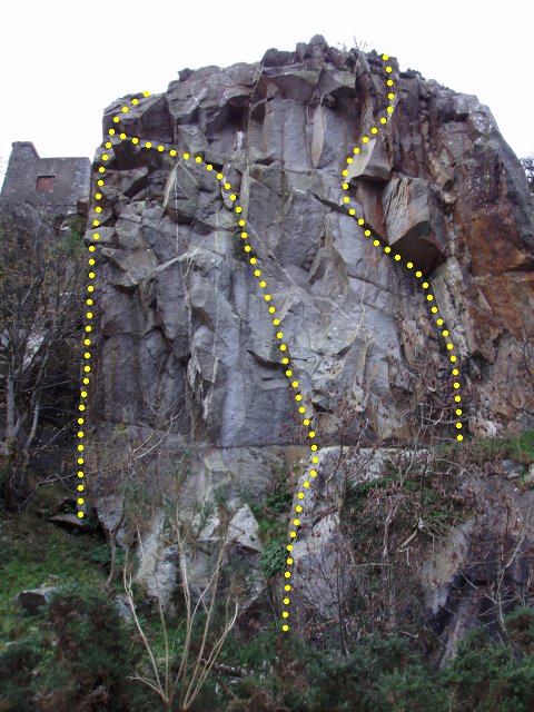
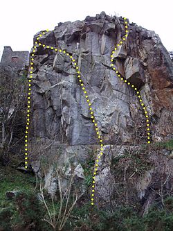 Central Buttress on the Upper Tier, home to the quarry's longest routes and some of the hardest. A selection, left to right: Slapstick (grade E7/6b), Central Buttress (E1/5b), Portcullis (E4/6a). The old signalling tower is visible at top left.
The quarry is laid out in four main sections. Above Ardbrugh Road lie three valleys. The Far East Valley is private property, occupied by a small "gated community", and closed to climbing; the East Valley which contains many important climbs; and the West Valley, which also contains many important climbs. Between the East and West valleys is a broad ridge along which the quarry railway used to run; this is used to gain access to the Upper Tier, which contains the quarry's highest cliffs. The Upper Tier is traversed by a tarmac path leading to the Killiney Hill car-park at one end, and a set of steps leading to the top of the hill at the other end; the path and steps are popular with strollers. The hilltop path follows a wall which skirts the top of the cliffs, and passes an old signalling tower which was used by the British military to signal to the neighbouring Martello towers during the 19th century.
Environment
Apart from the one path and steps, the quarry is not landscaped but is left wild; as a result it is heavily forested, and gorse and bramble thrive. The thick vegetation is home to a wide range of wildlife including foxes. In recent years, peregrine falcons have nested in the cliffs of the Upper Tier; climbing in the vicinity of the nests is banned during the nesting period.
Climbing
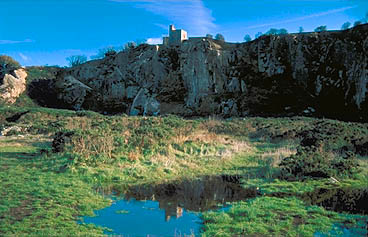
 Climbers on Gargoyle Groove (grade HVS/5b) in the West Valley.
In 1942, the quarry's first recorded climbs were made by members of the Irish Mountaineering Club (IMC), and a handwritten guidebook was published. These were the first significant steps in the development of climbing in Ireland; many of those first climbs remain popular and challenging routes for today's climbers.
Throughout the following decades, clearing of vegetation and loose rock by an increasing population of climbers uncovered many more quality climbs, and improvements in climbing techniques and equipment increased grades dramatically. The current guidebook, published in 2005, lists about 300 climbs, at grades up to E7. The climbs are nearly all single-pitch, between 10m and 35m in length. Climbs vary greatly in nature, with steep finger-cracks and bare slabs featuring prominently. Being granite (with some bands of quartz), friction is usually good, but being quarried, not as good as weathered granite. Protection varies but is generally good; in accordance with local ethics, there are no bolts on any climbs in the quarry, and the few remaining pitons are rarely replaced when they eventually break.
The quarry is a very important facility for Dublin climbers; on summer evenings the chirping of birds mingles with the jangling of climbing gear and calling of climbers to their partners. After climbing, Dalkey's pubs (especially the Ivory, previously called McDonaghs) play host to climbers who meet to quench their thirsts and talk about the day's events and plan future trips.
See also
References
- Ronan Browner and Howard Hebblethwaite (editors), Dalkey Quarry Rock Cimbing Guide (Mountaineering Ireland 2005) ISBN 0-902940-20-1 [1]
- Pearson, Peter (1998). Between the Mountains and the Sea: Dun Laoghaire-Rathdown County, Dublin: The O'Brien Press. ISBN 0-86278-582-0
External links
- [2] - Irish Climbing Online Wiki: Dalkey Quarry
- Dalkey Quarry Rock Climbing Guide
References
- ^ Pollock, J. (2004). Geology of the Roman Catholic Basilica of St. John the Baptist, St. John's, Newfoundland. Geoscience Canada, 31(1), 10-Jan.
- ^ "New halting sites law for Irish Travellers". European Roma Rights Centre. http://www.errc.org/cikk.php?cikk=2042. Retrieved 2009-12-07.
- ^ "Dalkey Quarry action criticised". Irish Times. http://www.irishtimes.com/newspaper/ireland/2010/0510/1224270050417.html.


Wikimedia Foundation. 2010.