- Aurunci Mountains
-
Aurunci Mountains (Monti Aurunci) Range Name origin: Ancient tribal name Country Italy Region Lazio District Latina, Frosinone Part of Apennine Mountains, Volsci Chain Borders on Monti Ausoni, Liri River, Garigliano river;
Tyrrhenian SeaHighest point Monte Petrella - elevation 1,533 m (5,030 ft) - coordinates 41°19′22″N 13°39′55″E / 41.32278°N 13.66528°E Geology limestone karst Orogeny Southern Apenninic Orogeny Period Messinian of Miocene, Pliocene-Pleistocene 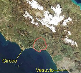 Location of the range in Italy
The Aurunci Mountains (Italian Monti Aurunci) is mountain range of southern Lazio, in central Italy. They are part of the Antiappennini, a group running from the Apennines chain to the Tyrrhenian Sea, where they form the promontory of Gaeta. They are bounded northwestward by the Ausoni Mountains, northward by the Liri river, eastward by the Ausente, southeastward by the Garigliano and southward by the Tyrrhenian sea. The line between the Aurunci and the Ausoni has not been clearly established but the Aurunci are considered by convention to be east of a line through Fondi, Lenola, Pico, S.Giovanni and Incarico.[1] Altitudes vary from hills to the 1,533 m of Monte Petrella. Main peaks include the Redentore (1,252 m) and Monte Sant'Angelo (1,402 m). They include a Regional Park, the Parco Naturale dei Monti Aurunci, created in 1997.
The mountains take the name from the ancient tribe of the Aurunci, an offshoot of the Ausoni. Both tribes were derived from the Italic people who were called by the Romans the Volsci; hence, the Monti Lepini, the Monti Ausoni and the Monti Aurunci are also called the Volsci or Volscian Chain.[2] Coincidentally they are all of the same karst topography and have the same orogeny, which is not quite the same as the Apennines proper.
Geology
The Monti Aurunci mainly consist of friable limestone, which becomes harder toward Gaeta. The degree of faulting and cracking is so high that the mountains retain no rainfall; it sinks in to emerge as springs (and in human times wells) on the lower flanks. The stream beds are dry except for vernal pools.
Most generally, the western central coastal region of Italy is the front of a subduction zone where the African plate moving locally from southwest to northeast is carried under the European plate. There is some counterclockwise rotation of Italy; hence the faults in the Tyrrhenian Sea slip both parallel to the shoreline and perpendicular to it.
The surface rock in the Anti-Apennines was deposited on the floor of Tethys Sea during the Jurassic and Cretaceous of the Mesozoic. This lighter calcareous rock rides over the front of the subduction zone, uplifted by compressional and isostatic forces. Just behind it is a zone of crustal thinning caused by extensional forces; i.e., the subduction and the rotation cause a wave of compression with a peak under the Anti-Apennines and a valley in the Tyrrhenian Sea. The result is a karst-graben or half-graben landform with the Volscian Mountains as karst and the coastal chain of Pontine marshes, South Pontine marsh, Terracina Basin, Gaeta Basin and Volturno Basin as graben.
This landform began to appear in the Messinian stage of the Miocene, about 7.2 to 5.3 million years ago. It went on to mature in the Pliocene. Also in this time volcanic activity associated with the faults and the weakening of the crust over the subduction created the volcanic zones of Latium and Campania, which intruded into the karst-graben, mainly on the karst side. In the Pleistocene the basins slowly filled with sediment from the weak run-off of the mountains, accelerating with the deforestation of modern times.[3][4]
Ecology
Fauna
Of the Amphibians, Urodela are found at around 557 m (1,827 ft) and Anura at around 314 m (1,030 ft) in vernal pools, springs and wells. The salamanders are Salamandrina perspicillata, Triturus carnifex, Lissotriton italicus and Lissotriton vulgaris; the frogs are Bufo bufo, Bufo viridis, Hyla intermedia and Rana italica.[5]
Radioactive pollution of the lower Garigliano
The Garigliano Nuclear Power Plant was constructed from 1959 to 1963 by General Electric on the Garigliano River, the water of which they used for cooling, on the border of the Monti Aurunci. It was intended to provide electrical power to the region. After several accidental releases of radioactive gas and water the plant ceased operation in 1978 but continued to be used as a storage facility for radioactive waste, which was stored under the plant. Subsequent flooding carried the waste downstream into the Gulf of Gaeta. The effect on the ecology was toxic. One study reports:[6]
In fact the genetic damage observed in studies performed with the micronucleus test applied on wild rodents from the Piana del Garigliano resulted among the highest recorded in Italy.
Additional studies were unable to tie anomalies of the skull and teeth in the area's rodents to contamination from the power plant; maybe they are attributable to a naturally high radiational level caused by the volcanic intrusions in the rock. The lower Garigliano remains sparsely populated.
See also
References
- ^ Romano 2007, p. 18.
- ^ Romano 2007, p. 17.
- ^ Vai, Gian Battista; Martini, Peter (2001). Anatomy of an orogen: the Apennines and adjacent Mediterranean basins. Dordrecht [u.a.]: Kluwer Academic Publishers. pp. 269–271.
- ^ Aiello, Gemma; Marsella, Ennio; Sacchi, Marco. "Quaternary structural evolution of Terracina and Gaeta basins (Eastern Tyrrhenian margin, Italy)" (pfd). Rendiconti Lincei. Series 9 11: Page 41. http://www.lincei.it/pubblicazioni/rendicontiFMN/rol/pdf/S2000-01-02.pdf.
- ^ Romano 2007, p. 19.
- ^ Amarena, Domenica; Ontoli, Longinoc; Cristaldi, Mauro (1993-1994). "Coenotic Structure, Skull Asymmetries and Other Morphological Anomalies in Small Mammals Near an Electronuclear Power Plant". Hystrix. New Series 5 (1-2): 41.
Bibliography
- Romano, Antonio; Montinaro, Gianpaolo; Mattoccia, Marco; Sbordoni, Valerio (2007). "Amphibians of the Aurunci Mountains (Latium, Central Italy). Checklist and conservation guidelines" (pdf). Acta Herpetologica 2 (1): 17–25. http://www.fupress.net/index.php/ah/article/viewFile/1881/1815.
External links
- "Parco Naturale dei Monti Aurunci" (in Italian, English). 2010. http://www.parks.it/parco.monti.aurunci/index.html. Retrieved February 8, 2010.
 Lazio
LazioProvinces Lakes Lake Albano • Lake Bolsena • Lake Bracciano • Lago di Canterno • Lago di Caprolace • Lago di Fondi • Lago di Giulianello • Lake Martignano • Lake Mezzano • Lago dei Monaci • Lake Nemi • Lago di Posta Fibreno • Lago di Rascino • Lago di Sabaudia • Lago del Salto • Lago del Turano • Lake VicoMountains Seven hills of Rome • Alban Hills • Aurunci Mountains • Monti Ausoni • Monte Cavo • Cimini Hills • Monti Ernici • Monte Gorzano • Monti della Laga • Monti Lepini • Monti della Meta • Monte Petrella • Monti Prenestini • Monti Sabatini • Monte Soratte • Monte Terminillo • Monti della Tolfa • Monti Volsini • Monte Cassino · Monte Abate · Monte Altino · Monte Appiolo · Maschio dell'Ariano · Maschio di Lariano · Monte Artemisio · Monte Autore · Monte Carbonaro · Monte Cefalo · Cima del Redentore (monti Aurunci) · Circeo · Monte Crispi · Monte Dragone · Monte Faggeto · Monte Fammera · Mont Fogliano · Monte Fusco · Monte Guadagnolo · Monte Lauro in Gaeta · Monte Lauzo · Le Rave Fosche · Monte Livata · Mainarde · Maschio delle Faete · Meta (monte) · Monna · Monte Caira · Monte Cervello · Monte Revole · Monte Sorgenze · Monte Trina · Monte Val de' Varri - Monte Faito - Monte San Nicola · Monte di Cambio · Monte le Pezze · Parco regionale urbano Monte Orlando · Monte Orso · Monte Pizzuto · Monte RuazzoGeographic
areasPolitics and
governmentAncient Lazio Etruscans • Latium • Latium adiectum • Latial culture • Latins (Italic tribe) • Sabines • Volsci • AequiLazio · Comuni of the Province of Latina Aprilia · Bassiano · Campodimele · Castelforte · Cisterna di Latina · Cori · Fondi · Formia · Gaeta · Itri · Latina · Lenola · Maenza · Minturno · Monte San Biagio · Norma · Pontinia · Ponza · Priverno · Prossedi · Rocca Massima · Roccagorga · Roccasecca dei Volsci · Sabaudia · San Felice Circeo · Santi Cosma e Damiano · Sermoneta · Sezze · Sonnino · Sperlonga · Spigno Saturnia · Terracina · VentoteneCategories:- Apennines
- Mountain ranges of Italy
- Mountains of Lazio
- Osci

Wikimedia Foundation. 2010.