Middleton-by-Youlgreave

Middleton-by-Youlgreave

Coordinates: 53°10′N 1°43′W / 53.16°N 1.71°W / 53.16; -1.71

Middleton
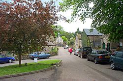
Middleton-By-Youlgrave 014815 3919b36d.jpg
in 2003
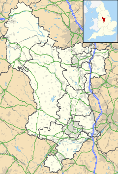
Middleton is located in Derbyshire
Middleton

 Middleton shown within Derbyshire
District Derbyshire Dales
Shire county Derbyshire
Region East Midlands
Country England
Sovereign state United Kingdom
Post town BAKEWELL
Postcode district DE45
Dialling code 01629
Police Derbyshire
Fire Derbyshire
Ambulance East Midlands
EU Parliament East Midlands
UK Parliament West Derbyshire
List of places: UK • England • Derbyshire

Middleton, often known as Middleton-by-Youlgreave or Middleton-by-Youlgrave to distinguish it from nearby Middleton-by-Wirksworth, is a village in the Peak District, Derbyshire, England. It lies south west of Youlgreave, above the River Bradford. Its main industries are farming and tourism.

History

This manor was mentioned in the Domesday book as belonging to Henry de Ferrers[1]; it included a mill and was worth sixteen shillings[2].

The village grew up during the Middle Ages. Middleton Castle, a fortified manor house, was built in the early seventeenth century, and saw some fighting during the English Civil War. Christopher Fulwood attempted to raise a Royalist force from his base in the Castle, but on 16 November 1643, Roundhead troops raided the house and killed Fulwood. The Castle now lies in ruins.

The settlement's present appearance dates from the early nineteenth century. Thomas Bateman rebuilt the entire village in the 1820s, incorporating the mullioned windows of earlier buildings to retain something of its traditional appearance. The small parish church also dates from this period, and Bateman rebuilt Middleton Hall as his own residence.

Bateman's grandson, the archaeologist also named Thomas Bateman, lived in the village, and built Lomberdale Hall as his residence.

An annual well dressing takes place in the village, and the village hosts an annual musical festival, showcasing local musicians every summer. Arbor Low lies two miles west of Middleton.

References

  1. ^ Henry was given a large number of manors in Derbyshire including Doveridge, Linton, Pilsbury and Cowley.
  2. ^ Domesday Book: A Complete Translation. London: Penguin, 2003. ISBN 0-14-143994-7 p.748

External links


Wikimedia Foundation. 2010.

Игры ⚽ Нужно решить контрольную?

Look at other dictionaries:

  • Middleton, Derbyshire — may refer to: Middleton by Wirksworth Middleton by Youlgreave This disambiguation page lists articles about distinct geographical locations with the same name. If an internal link led y …   Wikipedia

  • Middleton — It may also be spelled Middelton, Myddleton, and Myddelton. Middleton may refer to: Contents 1 Places 1.1 Australia 1.2 Canada 1.3 Ireland …   Wikipedia

  • Middleton — Para la localidad irlandesa del condado de Cork, véase Midleton. Middleton es una palabra inglésa que puede referirse a varios lugares y personas. En ocasiones es escrito como Middelton, Myddleton y Myddelton. La palabra viene del Idioma… …   Wikipedia Español

  • Derbyshire lead mining history — Goodluck Mine in Via Gellia. This article details some of the history of lead mining in Derbyshire, England. Contents 1 …   Wikipedia

  • Derbyshire Dales — For the Parliamentary constituency, see Derbyshire Dales (UK Parliament constituency). Derbyshire Dales District   District   …   Wikipedia

  • Arbor Low — Infobox Megalith Name = Arbor Low Photo = Arbor low 274167 560a8cc3.jpg Type = Henge monument Country = England County = Derbyshire Nearest Town = Bakewellcite web | url=http://www.megalithic.co.uk/article.php?sid=0003 | title=The Megalithic… …   Wikipedia

  • List of civil parishes in Derbyshire — poly 70 249 70 233 88 235 90 222 97 222 109 225 109 234 113 239 125 246 127 250 135 253 142 250 143 244 147 240 156 242 165 249 151 259 144 274 137 274 134 284 125 290 121 289 113 292 111 298 111 306 104 311 92 312 87 305 81 299 98 283 86 288 101 …   Wikipedia

  • River Bradford — Infobox River river name = River Bradford caption = Bradford Dale origin = near Middleton by Youlgrave mouth = River Lathkill basin countries = England length = elevation = mouth elevation = discharge = watershed = The River Bradford is a river… …   Wikipedia

  • DE postcode area — Derby postcode area …   Wikipedia

  • Derbyshire — Geografie Status: Zeremonielle und Verwaltungsgrafschaft Region: East Midlands Fläche …   Deutsch Wikipedia

Share the article and excerpts

Direct link
Do a right-click on the link above
and select “Copy Link”