Cowley, Derbyshire

Cowley, Derbyshire

Coordinates: 53°17′20″N 1°29′35″W / 53.289°N 1.493°W / 53.289; -1.493

Cowley
Cowley 125321 e9d87305.jpg
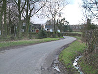
The small village of Cowley, with the white-painted Mission in the distance.
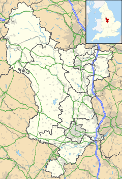
Cowley is located in Derbyshire
Cowley

 Cowley shown within Derbyshire
OS grid reference SK338770
District North East Derbyshire
Shire county Derbyshire
Region East Midlands
Country England
Sovereign state United Kingdom
Post town DRONFIELD
Postcode district S18
Police Derbyshire
Fire Derbyshire
Ambulance East Midlands
EU Parliament East Midlands
List of places: UK • England • Derbyshire

Cowley is a small dispersed settlement in North East Derbyshire, consisting of a few private houses and functioning farms strung out along Cowley Lane, which runs between the village of Holmesfield and the "Hill Top" neighbourhood of the town of Dronfield. It holds an annual well dressing[1] in the grounds of Cowley Mission, a small chapel founded in 1888 and still active.[2]

History

Cowley is mentioned in the Domesday book as belonging to Henry de Ferrers and being worth ten shillings. Henry was given a large number of manors in Derbyshire including Doveridge, Breaston, Duffield and Hartshorne.[3]

The name Cowley has been described as coming from two Old English words, col for coal or earlier charcoal and leah for clearing, suggesting the charcoal burners' clearing. Coal (the Silkstone seam) is close to the surface in this area and has been worked for centuries,[4] though no longer. Early coal workings would have been shallow, probably bell pits; the nearest, deeper shaft marked on the Ordnance Survey map is about 800 m north of Cowley at SK337778, on the edge of modern Dronfield.

References

  1. ^ Alliance North Midlands site "Cowley Welll Dressing". http://www.alliancenorthmidlands.co.uk/location/ne-derbyshire/19 Alliance North Midlands site. 
  2. ^ "Cowley Mission". http://www.dronfieldtogether.org.uk/churches/cowley-mission. Retrieved 2011-02-05. 
  3. ^ Domesday Book: A Complete Translation. London: Penguin, 2003. ISBN 0-14-143994-7 p.748
  4. ^ Nixon, Frank (1969). Industrial Archaeology of Derbbysyire. Newton Abbot: David & Charles. ISBN ISBN 7153 4351 3. 

External links

Media related to Cowley, Derbyshire at Wikimedia Commons


Wikimedia Foundation. 2010.

Игры ⚽ Нужно сделать НИР?

Look at other dictionaries:

  • Cowley — bezeichnet den englischen Adelstitel Earl Cowley mehrere Orte in England: Cowley (Derbyshire) Cowley (Gloucestershire) Cowley (London), ein Stadtteil des London Borough of Hillingdon Cowley (Oxfordshire) in Kanada: Cowley (Alberta) in den… …   Deutsch Wikipedia

  • Cowley — may refer to: Places In Australia: Cowley County, New South Wales In Canada: Cowley, Alberta In England: Cowley, Derbyshire Cowley, Devon Cowley, Gloucestershire Cowley, London Cowley, Oxford Cowley, Staffordshire In the United States: Cowley,… …   Wikipedia

  • Cowley (surname) — For other uses, see Cowley. Cowley Gender Unisex Language(s) English Origin Language(s) 1. English 2. Irish Cowley is a surname in the …   Wikipedia

  • Cowley — This name is of English locational origin from any of the several places thus called. Cowley in Buckinghamshire, Oxfordshire, Devonshire and Staffordshire, recorded respectively as Cufanlea, Couela, Couelegh and Covelav in Anglo Saxon Records for …   Surnames reference

  • Ash, Derbyshire — Infobox UK place country = England static static image caption= latitude = 52.892 longitude = 1.620 scale = 20000 map type = Derbyshire official name = Ash local name = population = shire district = South Derbyshire shire county = Derbyshire… …   Wikipedia

  • Shirley, Derbyshire — Infobox UK place country = England static static image caption=The Saracen s Head, Shirley. latitude = 52.971 longitude = 1.676 map type = Derbyshire official name = Shirley population = shire district = Derbyshire Dales shire county = Derbyshire …   Wikipedia

  • Hartshorne, Derbyshire — Infobox UK place country = England static static image caption=St Peter s church latitude = 52.789 longitude = 1.526 map type = Derbyshire official name = Hartshorne population = shire district = South Derbyshire shire county = Derbyshire region …   Wikipedia

  • Hilton, Derbyshire — infobox UK place country = England static static image caption= Hilton Millennium Clock latitude= 52.871 longitude= 1.637 official name= Hilton population= 3,871 (2001) shire district= South Derbyshire shire county = Derbyshire region= East… …   Wikipedia

  • Milford, Derbyshire — Milford Church Milford is a village in Derbyshire, England, on the River Derwent, between Duffield and Belper on the A6 trunk road. Until the end of the 18th century it was no more than a few houses near the point, about a quarter of a mile… …   Wikipedia

  • Каули — …   Википедия

Share the article and excerpts

Direct link
Do a right-click on the link above
and select “Copy Link”