- Nankaidō
-
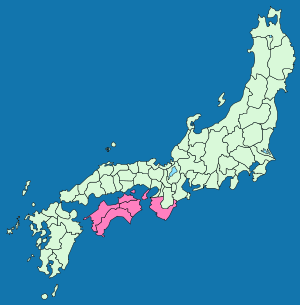
The Nankaidō (南海道), literally meaning "southern sea road," is a Japanese term denoting both an ancient division of the country and the main road running through it.[1] The road connected provincial capitals in this region.[2] It was one of the Gokishichidō.
The Nankaidō encompassed the pre-Meiji provincial lands of Kii and Awaji, plus the four provinces that made up the island of Shikoku: Awa, Sanuki, Tosa, and Iyo.[3]
The road extend from Nara to the seacoast to the south on the Kii Peninsula of the island of Honshū in Japan and crossing the sea, extended to Yura (nowadays Sumoto) and then Shikoku.
Contents
Nankaidō earthquakes
- See Historic tsunami for a full list of Nankai quakes with tsunami.
Many historic earthquakes bear the name "Nankai" or "Nankaido", as specific epicenters were known at the time. Often quakes take on the Japanese era name along with location such as Nankaido. These include:
- 1498 Meiō Nankaidō earthquake
- 1605 Keichō Nankaidō earthquake
- 1854 Ansei-Nankai earthquake
- 1944 Tōnankai earthquake
- Nankai Earthquake (南海地震) measuring 8.4 hit at 4:19 [local time] there was a catastrophic earthquake on the southwest of Japan in the Nankai area. It was felt almost everywhere in the central and western parts of the country. The tsunami washed away 1451 houses, caused 1500 deaths in Japan, and was observed on tide gauges in California, Hawaii, and Peru. [4]
See also
Notes
- ^ Nussbaum, Louis-Frédéric. (2005). "Goki-shichidō" in Japan Encyclopedia, p. 255 at Google Books; n.b., Louis-Frédéric is pseudonym of Louis-Frédéric Nussbaum, see Deutsche Nationalbibliothek Authority File.
- ^ Titsingh, Isaac. (1834). Annales des empereurs du japon, pp. 65-66. at Google Books
- ^ Titsingh, p. 65 n3. at Google Books
- ^ JNOAA Earthquake Database Query
References
- Nussbaum, Louis-Frédéric and Käthe Roth. (2005). Japan encyclopedia. Cambridge: Harvard University Press. 10-ISBN 0-674-01753-6; 13-ISBN 978-0-674-01753-5; OCLC 58053128
- Titsingh, Isaac. (1834). Nihon Odai Ichiran; ou, Annales des empereurs du Japon. Paris: Royal Asiatic Society, Oriental Translation Fund of Great Britain and Ireland. OCLC 5850691
Gokishichidō (five provinces and seven circuits) Five provinces Seven circuits Former provinces of Japan (List) Kinai Tōkaidō Tōsandō Hokurikudō San'indō San'yōdō Nankaidō Saikaidō Hokkaidō
1869-1882Ancient pre-Taihō Code provinces included: Fusa · Hi · Keno · Kibi · Koshi · Kumaso · Toyo · Tsukushi
________________
Source: Nussbaum, Louis-Frédéric. (2005). "Provinces and prefectures" in Japan Encyclopedia, p. 780 at Google Books; excerpt,- "Japan's former provinces were converted into prefectures by the Meiji government ... [and] grouped, according to geographic position, into the 'five provinces of the Kinai' and 'seven circuits'."
Categories:- Regions of Japan
- Road transport in Japan
- Old provinces of Japan
- Japanese history stubs
- Japan road stubs
Wikimedia Foundation. 2010.

