- Dewa Province
-
This article is about the former province in Japan. For the Indonesian band, see Dewa (band).
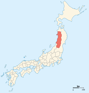 Map of Japanese provinces (1868) with Dewa Province highlighted
Dewa Province (出羽国 Dewa no kuni) is an old province of Japan, comprising modern-day Yamagata Prefecture and Akita Prefecture,[1] except for the city of Kazuno and the town of Kosaka. It was sometimes called Ushū (羽州).
Historical record
In 708 CE, the land of Dewa-no kuni was administratively separated from Echigo; and the ambit of the province was gradually extended to the north as the Japanese pushed back the indigenous people of northern Honshū.
In 712, Dewa Province was administratively realigned in relation to Mutsu Province (陸奥国); and Empress Gemmei's Daijō-kan continued to organize other cadastral changes in the provincial map of the Nara Period, as in 713 when Mimasaka Province (美作国) was divided from Bizen Province (備前国); Hyūga Province (日向国) was sundered from Osumi Province (大隈国); and Tamba Province (丹波国) was severed from Tango Province (丹後国).[2]
In 1335, Shiba Kaneyori received the Dewa Province as a fief from Ashikaga Takauji.[3]
In the Sengoku Period, the southern region around Yamagata was held by the Mogami clan and the northern part by the Akita clan, both of which fought for Tokugawa Ieyasu at the Battle of Sekigahara.
In the late 19th century, Dewa Province was again administratively reconfigured, this time into Uzen and Ugo before being substantively recast along with all the other old provinces into the modern prefectural pattern of Japan.
Notes
- ^ Kōdansha. (1993). "Akitajō" in Japan: an Illustrated Encyclopedia, Vol. 1, p. 29.
- ^ Titsingh, Isaac. (1834). Annales des empereurs du japon, p. 64. at Google Books
- ^ Terry, Thomas Philip. (1914). Terry's Japanese Empire, p. 324. at Google Books
References
- Kōdansha. (1993). Japan: an Illustrated Encyclopedia. Tokyo: Kōdansha; OCLC 193352222
- Terry, Thomas Philip. (1914). Terry's Japanese Empire: including Korea and Formosa, with Chapters on Manchuria, the Trans-Siberian Railway, and the Chief Ocean Routes to Japan: a Guidebook for Travelers. New York: Houghton Mifflin. OCLC 123254449
- Titsingh, Isaac. (1834). Nihon Odai Ichiran; ou, Annales des empereurs du Japon. Paris: Royal Asiatic Society, Oriental Translation Fund of Great Britain and Ireland. OCLC 5850691.
Former provinces of Japan (List) Kinai Tōkaidō Tōsandō Hokurikudō San'indō San'yōdō Nankaidō Saikaidō Hokkaidō
1869-1882Ancient pre-Taihō Code provinces included: Fusa · Hi · Keno · Kibi · Koshi · Kumaso · Toyo · Tsukushi
________________
Source: Nussbaum, Louis-Frédéric. (2005). "Provinces and prefectures" in Japan Encyclopedia, p. 780 at Google Books; excerpt,- "Japan's former provinces were converted into prefectures by the Meiji government ... [and] grouped, according to geographic position, into the 'five provinces of the Kinai' and 'seven circuits'."
Coordinates: 39°00′59″N 140°19′02″E / 39.01639°N 140.31722°E
Categories:- Old provinces of Japan
- States and territories established in 708
- Akita geography stubs
- Yamagata geography stubs

Wikimedia Foundation. 2010.