- Neversink River
-
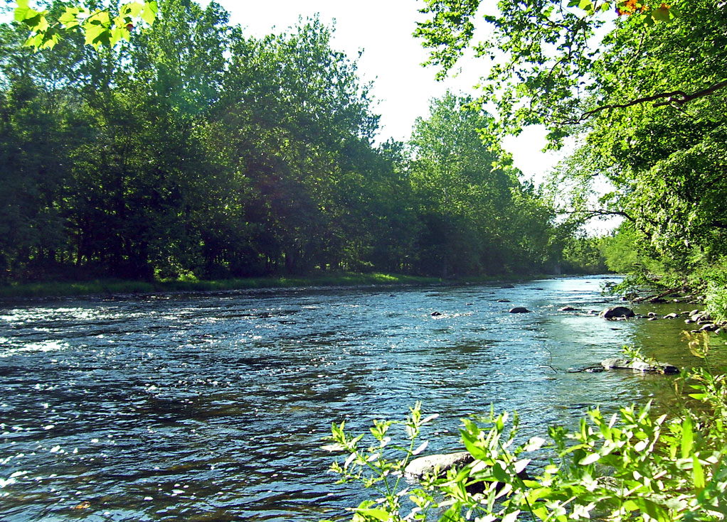
Neversink River River  The Neversink near Cuddebackville
Country United States State New York Counties Orange, Sullivan City Port Jervis Source East Branch Neversink River - location S of col between Slide and Cornell mountains, Town of Shandaken, Ulster County - elevation 2,960 ft (902 m) - coordinates 41°59′40″N 74°22′21″W / 41.99444°N 74.3725°W Secondary source West Branch Neversink River - location NW slope of Slide Mountain, Town of Shandaken - elevation 3,480 ft (1,061 m) - coordinates 42°00′19″N 74°23′29″W / 42.00528°N 74.39139°W Source confluence - location S of Claryville, Sullivan County - elevation 1,600 ft (488 m) - coordinates 41°54′57″N 74°34′29″W / 41.91583°N 74.57472°W Mouth Delaware River - elevation 400 ft (122 m) - coordinates 41°21′26″N 74°41′43″W / 41.35722°N 74.69528°W Length 55 mi (89 km) Basin 435 sq mi (1,127 km2) Discharge for Bridgeville - average 212 cu ft/s (6 m3/s) - max 361 cu ft/s (10.2 m3/s) - min 112 cu ft/s (3.2 m3/s) Discharge elsewhere (average) - Claryville 174 cu ft/s (4.9 m3/s)  The Neversink and its two branches
The Neversink River (also called Neversink Creek in its upper course) is a 55-mile-long (89 km)[1] tributary of the Delaware River in southeastern New York in the United States. The name of the river comes from an Algonquian language phrase meaning "mad river."
Because of Theodore Gordon expertly matching dry fishing flies to actual insects in the 1890s, and due to the research of Edward Ringwood Hewitt from his property above the town of Neversink, the Neversink River is considered by many to be the birthplace of American dry fly fishing.[2]
Contents
Course
 Confluence of east and west branches near Claryville
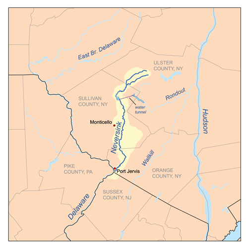
The Neversink's main flow begins just south of the border between Ulster and Sullivan counties, where the east and west branches of the river join near the hamlet of Claryville. Both branches begin on the slopes of Slide Mountain, the highest peak in the Catskills. The west branch is joined by several major tributaries, such as Biscuit Brook and Pigeon Creek at Frost Valley YMCA in the town of Shandaken, Ulster County. In its upper course it is a rocky and wild stream, ideal for trout fishing although most of the land around it is privately owned.
Not far downriver from the confluence in Neversink, it is impounded to form the Neversink Reservoir. It is connected by a 5-mile (8 km) water tunnel to Rondout Reservoir, and subsequently to the Delaware Aqueduct. The Neversink Reservoir resulted in the displacement of many locals as several towns along the river were flooded to make the reservoir.
It flows generally southeast through the mountains and is impounded in the town of Neversink to form the Neversink Reservoir of the New York City Water Supply System. It flows through the town of Fallsburg, the hamlets of Woodbourne, South Fallsburg, and Old Falls. It then enters the town of Thompson near Bridgeville, where it intersects New York State Route 17/Interstate 86 at Exit 107. It runs past Holiday Mountain Ski Area. In southern Sullivan County, it returns to less developed country, going over its largest waterfalls, Denton Falls and High Falls in the Neversink Gorge. It then turns southeastward into western Orange County. Near Cuddebackville, it is joined from the northeast by Basher Kill, then flows southwest, paralleling US 209, joining the Delaware at Port Jervis, at Tristate Rock, where New York, New Jersey, and Pennsylvania converge underneath the Interstate 84 bridge.
Recreation
Along much of its length it is a popular trout stream, mostly north of Woodbourne. In addition to rainbow trout, brown trout, and brook trout, the river is home to other fish species such as smallmouth bass, carp, sucker, bluegill, American eel,lampreys and a diverse range of flora and fauna. Other forms of recreation are rarely pursued on the river. Several swimming holes are available, however many are on private property or restricted public property. The relative narrow nature of the river allows for limited boating. The river is mostly navagable with small watercraft from near its dam in Hasbrouck to its mouth, however, it is seldom traveled. In the late 19th century the river was said to have been navagable to Claryville, where a tannery existed. The river may have been a popular route for the tannery's trade as well as smaller steam propelled vessels.
It was formerly crossed by the Delaware & Hudson Canal at Cuddebackville by an early aqueduct bridge designed by John Roebling and built in 1851.
History
In heavy rains it sometimes floods near its mouth. This occurred most recently in April 2005, causing some destruction and dislocation in the Port Jervis area, particularly the Myers Grove community near Huguenot, that continues to have an effect. In addition, heavy rains in combination with an extended period of unusually warm weather after a moderate to heavy winter with a considerable snowpack can produce devastating floods at the headwaters of the river from January to April.
A detailed history of the river can be found in James Eldrige Quinlan's History of Sullivan County, published in 1873.
Tributaries
- Basher Kill
- Sheldrake Stream
- Eden Brook
- Mullet Brook
- Monell Brook
See also
- Cuddebackville Dam
- List of crossings of the Neversink River
- List of New York rivers
- Neversink Preserve
References
- Notes
- ^ U.S. Geological Survey. National Hydrography Dataset high-resolution flowline data. The National Map, accessed April 1, 2011
- ^ Askins, Justin. The Legendary Neversink, page xv
External links
- 1851 Neversink Aqueduct
- The Neverskink Valley Area Museum
- D&H Canal Historical Society
- USGS Report, Flood of April 2–3, 2005, Neversink River BasinPDF (17.3 MB)
Reservoirs
(Croton Watershed)Reservoirs
(Catskill/Delaware Watershed)Controlled Lakes Waterways Croton River · West Branch Croton River · Middle Branch Croton River · East Branch Croton River · Titicus River · Muscoot River · Cross River · Esopus Creek · Neversink River · Rondout Creek · Delaware River · East Branch Delaware River · West Branch Delaware RiverAqueducts New Croton Aqueduct · Croton Aqueduct (decommissioned) · Catskill Aqueduct · Shandaken Tunnel · Delaware Aqueduct · Neversink Tunnel · East Delaware Tunnel · West Delaware TunnelStorage Reservoirs Croton Distributing Reservoir (decommissioned) · Highbridge Reservoir (decommissioned) · Hillview Reservoir · Jerome Park Reservoir · Jacqueline Kennedy Onassis Reservoir (decommissioned) · Silver Lake Reservoir · Ridgewood Reservoir (decommissioned) · Williamsbridge Reservoir (decommissioned)Distribution Tunnels New York City Water Tunnel No. 1 · New York City Water Tunnel No. 2 · New York City Water Tunnel No. 3 (under construction) · Richmond TunnelCategories:- Rivers of New York
- Neversink River
- Catskill/Delaware Watersheds
- Rivers of Orange County, New York
- Geography of Sullivan County, New York
- Visitor attractions in Sullivan County, New York
- Place names in New York of Native American origin
- Tributaries of the Delaware River

Wikimedia Foundation. 2010.