- Mrągowo County
-
Mrągowo County
Powiat mrągowski— County — 
Flag
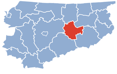
Coat of armsLocation within the voivodeship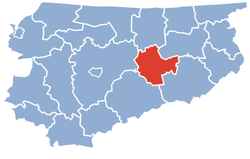 Division into gminas
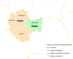
Coordinates (Mrągowo): 53°52′N 21°18′E / 53.867°N 21.3°ECoordinates: 53°52′N 21°18′E / 53.867°N 21.3°E Country  Poland
Voivodeship Warmian-Masurian Seat Mrągowo Gminas Total 5 (incl. 1 urban)Area – Total 1,065.23 km2 (411.3 sq mi) Population (2006) – Total 50,087 – Density 47/km2 (121.8/sq mi) – Urban 25,620 – Rural 24,467 Car plates NMR Website http://www.powiat.mragowo.pl Mrągowo County (Polish: powiat mrągowski) is a unit of territorial administration and local government (powiat) in Warmian-Masurian Voivodeship, northern Poland. It came into being on January 1, 1999, as a result of the Polish local government reforms passed in 1998. Its administrative seat and largest town is Mrągowo, which lies 54 kilometres (34 mi) east of the regional capital Olsztyn. The only other town in the county is Mikołajki, lying 21 km (13 mi) east of Mrągowo.
The county covers an area of 1,065.23 square kilometres (411.3 sq mi). As of 2006 its total population is 50,087, out of which the population of Mrągowo is 21,772, that of Mikołajki is 3,848, and the rural population is 24,467.
Neighbouring counties
Mrągowo County is bordered by Kętrzyn County to the north, Giżycko County to the east, Pisz County to the south-east, Szczytno County to the south and Olsztyn County to the west.
Administrative division
The county is subdivided into five gminas (one urban, one urban-rural and three rural). These are listed in the following table, in descending order of population.
Gmina Type Area
(km²)Population
(2006)Seat Mrągowo urban 14.8 21,772 Gmina Mikołajki urban-rural 256.4 8,435 Mikołajki Gmina Piecki rural 314.6 7,769 Piecki Gmina Mrągowo rural 294.9 7,485 Mrągowo * Gmina Sorkwity rural 184.6 4,626 Sorkwity * seat not part of the gmina References
Seat Mrągowo (urban gmina)
Urban-rural gmina Rural gminas Counties of Warmian-Masurian Voivodeship City counties 
Land counties Categories:- Mrągowo County
- Land counties of Warmian-Masurian Voivodeship


Wikimedia Foundation. 2010.