- Ełk County
Infobox Settlement
name = Ełk County
native_name = Powiat ełcki
settlement_type = County
total_type = Total
image_shield = POL powiat ełcki COA.svg
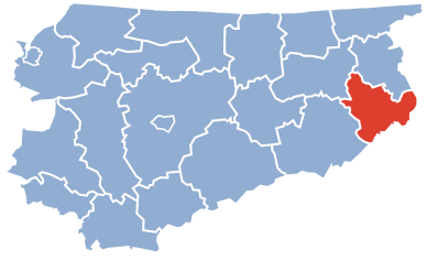
map_caption = Location within the voivodeship

map_caption1 = Division into gminas
subdivision_type = Country
subdivision_name = POL
subdivision_type1 = Voivodeship
subdivision_name1 = Warmian-Masurian
area_total_km2 = 1111.87
population_total = 84760
population_as_of = 2006
population_density_km2 = auto
population_urban = 56156
population_blank1_title = Rural
population_blank1 = 28604
coor_type = Ełk
latd = 53
latm = 49
lats = 17
latNS = N
longd = 22
longm = 21
longs = 44
longEW = E
seat =Ełk
parts_type =Gmina s
parts = Total 5 (incl. 1 urban)
p1 =Ełk
p2 =Gmina Ełk
p3 =Gmina Kalinowo
p4 =Gmina Prostki
p5 =Gmina Stare Juchy
blank_name = Car plates
blank_info = NEL
website = http://www.powiat.elk.pl __NOTOC__Ełk County ( _pl. powiat ełcki) is a unit of territorial administration and local government (powiat ) inWarmian-Masurian Voivodeship , northernPoland . It was created onJanuary 1 ,1999 as a result of the Local Government Reorganization Act of 1998. Its administrative seat and only town isEłk , which lies convert|123|km|mi|0 east of the regional capitalOlsztyn .The county covers an area of convert|1111.87|km2|sqmi|1. As of 2006 its total population is 84,760, out of which the population of Ełk is 56,156 and the rural population is 28,604.
Neighbouring counties
Ełk County is bordered by
Olecko County to the north,Suwałki County to the north-east,Augustów County to the east,Grajewo County to the south, andPisz County andGiżycko County to the west.Administrative division
The county is subdivided into five
gmina s (one urban and four rural). These are listed in the following table, in descending order of population.References
* [http://www.stat.gov.pl/gus/45_655_PLK_HTML.htm Polish official population figures 2006]
Wikimedia Foundation. 2010.