- Mrągowo
-
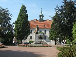
Mrągowo Town Hall 
Flag
Coat of armsCoordinates: 53°52′N 21°18′E / 53.867°N 21.3°E Country  Poland
Voivodeship Warmian-Masurian County Mrągowo County Gmina Mrągowo (urban gmina) Established 1348 Town rights 1444 Government – Mayor Otolia Anna Siemieniec Area – Total 14.8 km2 (5.7 sq mi) Highest elevation 200 m (656 ft) Lowest elevation 20 m (66 ft) Population (2006) – Total 21,772 – Density 1,471.1/km2 (3,810.1/sq mi) Time zone CET (UTC+1) – Summer (DST) CEST (UTC+2) Postal code 11-700 to 11-709 Area code(s) +48 89 Car plates NMR Website http://www.mragowo.um.gov.pl Mrągowo [mrɔŋˈɡɔvɔ] (former Polish: Żądźbork; German:
 Sensburg (help·info), Lithuanian: Senpilė) is a town in the Warmian-Masurian Voivodeship of northeastern Poland, the capital of Mrągowo County and the seat (though not part of) the Gmina Mrągowo. It is located within the Masurian Lake District, about 60 km (37 mi) east of Olsztyn.
Contents
History
About 1348 the Teutonic Knights constructed a wooden fortress near present-day Mrągowo named Sensburg, derived from Old Prussian senas meaning "old", therefore maybe at the site of a former Prussian castle. The settlement that began to develop nearby was first mentioned in a 1397 deed and probably had already received Kulm town rights between 1404 and 1407, although it is verified that Grand Master Konrad von Erlichshausen affirmed town rights in 1444. Sensburg became part of the Duchy of Prussia in 1525. In the 15th and 16th centuries, the town suffered through fires and plagues. Part of the Kingdom of Prussia since 1701, Sensburg was incorporated into the Province of East Prussia. It was heavily devastated during the Napoleonic Wars.
The town itself mostly remained a small hamlet in the mostly rural area around it. Agriculture, fishing and the richness of the surrounding forests provided the sources of income for the local population. In 1871 Sensburg became part of the German Empire during the Prussian-led unification of Germany. In 1897 the town became connected to the railway system, which went from Bischofsburg (Biskupiec) to Rastenburg (Kętrzyn). As a result of the Treaty of Versailles on 11 July 1920 the East Prussian plebiscite was organized under the control of the League of Nations, which resulted 99,93 % of votes to remain in Germany (33.334 total) and 0,07 % for Poland (25 total).
At the end of World War II the town was overrun by the Red Army during the East Prussian Offensive and lost almost 20% of its buildings. The German population remaining after the evacuation was largely expelled after the war and replaced with Poles. From 1945 to 1947 the stolen city was known by the Polonized name Żądzbork. The city's name was, like other Prussian cities, changed to the current Mrągowo in 1947, in honor of Pastor Christoph Mrongovius (1764–1855), known in Polish as Krzysztof Celestyn Mrongowiusz.
After the war Mrągowo remained a rural town with approximately 10,000 inhabitants; this number stayed almost constant until the late 1980s. In the following decade, mostly due to economic and political changes, the town gained some influence in the region and grew quickly into a regional center for economic business and tourism. Recently Mrągowo has tried to regain some of its former beauty and to represent the region. Piknik Country is an annual country music festival held in the town.
Coat of arms
The town's coat of arms derives from a local story of the 15th century. It claims that when a group of local farmers was being threatened by predators, the townspeople tracked down a fearsome bear. They were only able to shoot it in its paw, and it managed to flee to Rastenburg. Only upon its arrival there did the bear succumb to its injuries. The bear's paw was brought back to Sensburg and is honored in the coat of arms.
International relations
Twin towns — Sister cities
Mrągowo is twinned with:
 Grünberg, Germany – since 1993
 Limanowa, Poland – since 2006
 Zelenogradsk, Russia
Notable people
- Georg Riedel (1676–1738), composer
- Joachim Philipkowski (b. 1961), soccer player
External links
- Official website
- Mrągowo at e-Masuren.com (German)
- See pictures from the Antonio Mucherino's web site
Coordinates: 53°52′N 21°18′E / 53.867°N 21.3°E
Seat Mrągowo (urban gmina)
Urban-rural gmina Rural gminas Gmina Mrągowo Seat (not part of the gmina) MrągowoVillages Bagienice • Bagienice Małe • Bagnowski Dwór • Boża Wólka • Boże • Boże Małe • Brodzikowo • Budziska • Czerniak • Czerwonki • Dobroszewo • Gązwa • Głazowo • Gniazdowo • Grabowo • Gronowo • Gwiazdowo • Joachimowo • Karwie • Kiersztanowo • Kosewo • Kosewo Górne • Krzosowo • Krzywe • Kucze • Lasowiec • Lembruk • Marcinkowo • Miejski Las • Mierzejewo • Młynowo • Muntowo • Nikutowo • Notyst Dolny • Notyst Mały • Notyst Wielki • Nowe Bagienice • Nowy Probark • Palestyna • Pełkowo • Piotrówka • Polska Wieś • Popowo Salęckie • Porębiska • Poręby • Probark • Ruska Wieś • Rydwągi • Sądry • Śniadowo • Sobięcin • Szczerzbowo • Szestno • Troszczykowo • Tymnikowo • Użranki • Wierzbowo • Witomin • Wola Muntowska • Wólka Bagnowska • Wólka Baranowska • Wymysły • Wyszembork • Zalec • ZawadaCategories:- History of Prussia
- Cities and towns in Warmian-Masurian Voivodeship
- Mrągowo County
Wikimedia Foundation. 2010.


