- Onitsha
-
Onitsha
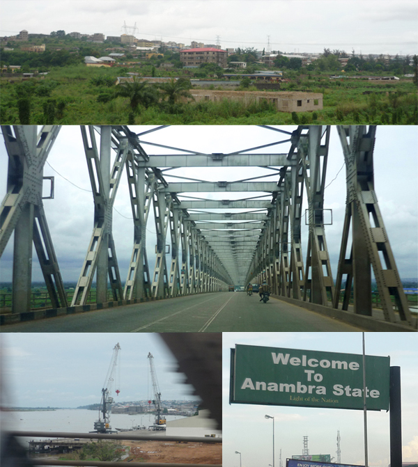
Ọnịcha Mmili— City — Top: Onitsha landscape.
Middle: River Niger Bridge heading from Onitsha.
Bottom left: The Onitsha Niger River Port. Bottom right: Welcome signboard while entering Onitsha, Anambra State.Onitsha in Nigeria
 Onitsha
Coordinates: 6°10′N 6°47′E / 6.167°N 6.783°E Country  Nigeria
State Anambra State LGA Onitsha North, Onitsha South Founded 1550 Government – Obi Igwe Nnayelugo Alfred Nnaemeka Achebe Area[1] – City 14 sq mi (36.19 km2) – Land 13.9 sq mi (36.12 km2) – Water 0 sq mi (0.067 km2) – Urban 9.8 sq mi (25.45 km2) – Metro 14 sq mi (36.19 km2) Population (2002)[1][2] – City 2,511,000 – Density 113,902.5/sq mi (43,978/km2) – Metro 1,003,000 – Ethnicity Igbo 90%>, Others – Demonym Onye Onicha (Igbo) Time zone WAT (UTC+1) Postcode 430...[3] Area code(s) 046 Onitsha (Igbo: Ọnịcha Mmili[4] or just Ọnịcha)[5] is a city, a commercial, educational, and religious center and river port on the eastern bank of the Niger river in Anambra State, southeastern Nigeria.
In the early 1960s, before the Nigerian Civil War (see also Biafra), the population was officially recorded as 76,000, and the town was distinctive in a number of dimensions; the great Nigerian writer Chinua Achebe (born and raised in the contiguous town of Ogidi) characterized it as harboring an "esoteric region from which creativity sallies forth at will to manifest itself," "a zone of occult instability" (see "Onitsha Matters" [1]). Though it experienced great suffering during and after the civil war, by virtue of its still-strategic geographic position Onitsha has continued to develop, and by 2001 had an estimated population of 511,000 with a metropolitan population of 1,003,000.[2] It is currently one of the fastest growing cities in the world.
The indigenous people of Onitsha are Igbo and speak the [[Igbo language. It is here worth noting that Onitsha should not be confused with the local municipality of Onicha lying further east in Nigeria. Onicha-Uboma, Onicha-Uburu, Onicha-Nwenkwo are just some of smaller Onicha scattered across southern Nigeria.
Contents
History
Most theories on the word 'Onicha' point to the meanings "despiser" or "arrogant"; apparently the people of Onitsha were prone to "look down" upon the people of the towns adjacent to them.[6] 'Onicha' may be a contraction of either 'Ọnịsịlị-ncha', meaning 'too headstrong [to be disciplined]'; Ọnyịsịlị-ncha, 'too headstrong [for everyone]'; or 'Ani-Ocha', 'the fair or white land'. Some claim that 'Onicha' is a contraction of Igbo and Edo words, and perhaps from the word 'Orisha'. However, the existence of quite a number of communities bearing 'Onicha' in the eastern Igbo hinterland, whose history do not relate to Edo, did severely jeopardise this hypothesis. Onicha-Uboma, Onicha-Uburu, Onicha-Nwenkwo are just some of these lesser known Onicha scattered in Igboland.[7]
Onitsha was known as Ado N'Idu by citizens who departed from the vicinity of the Kingdom of Benin near the far western portion of Igboland (near what is now Agbor), after a violent dispute with the Oba of Benin that can be tentatively dated to the early 1500s.[8] Traveling eastward through what is now Western Igboland (and various towns also called "Onitsha", for example Onicha-Ugbo, "farmland-Onitsha"), the Onitsha, led by one Chima eventually crossed the Niger River (Igbo: Orimili) and settled on the east bank in their current location[9]
After their arrival on the east bank (Onicha-mmili,"Onitsha-on-water", see above), the community gradually became a unitary kingdom, evolving from a loosely organized group of "royal" and "non-royal" villages into a more centralized entity.[10] Eze Aroli, was apparently the first genuinely powerful Obi of Onitsha, the ruler of the city.[11]
In 1857 British palm oil traders established a permanent station in the city, Christian missionaries joining them headed by the liberated African bishop Samuel Ajayi Crowther (a Yoruba recaptive) and Reverend John Taylor (an Igbo Recaptive).[12] In 1900 Onitsha became part of a British protectorate.[13]{ The British colonial government and Christian missionaries penetrated most of Igboland to set up their administration, schools and churches through the river port at Onitsha.
Modern history
Onitsha became an important trading port for the Royal Niger Company in the mid 1850s following the abolition of slavery and with the development of the steam engine when Europeans were able to move into the hinterland. Trade in palm kernels and palm oil which was going on on the coast of Bight of Biafra since 12th century was now moved upwards and other cash crops also boomed around this river port in the 19th century. Immigrants from the hinterland of Igboland were drawn to the emerging boom town as did the British traders who settled there in Onitsha, and coordinated the palm oil and cash crops trade. In 1965, the Niger River Bridge was built across the Niger River to replace the ferry crossing.
Demography
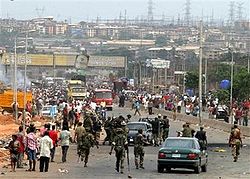 An Onitsha street scene.
Today, Onitsha is a modern day urban society, the people speak Igbo and English languages. There is a catholic cathedral, Anglican cathedral and it is the headquarters of so may church organizations and sociocultural groups. A federal government college is situated in the town. There is an army barrack, a school of metallurgy, and it is the home of the biggest market in the whole of Africa, the Onitsha Main Market.
Population
The population of Onitsha is not reflected in the Nigerian census figures and the trader migrate to their bases, neighbouring villages and states during census events reducing the official figures. Onitsha also serves as base for some major industries.
Economy
The state of Lagos and various northern towns are partially fed by supplies from Onitsha. Trade soared between the east and west of Nigeria because of Onitsha market. This made Onitsha the strategic gateway for trade between the former eastern and western regions. The Nigerian-Biafran war brought widespread devastation to the city; at its end came the subsequent oil boom years bringing a huge influx of immigrants into the city. The war-damaged facilities, still under repair, could not cope with the pace of the rural-urban exodus into the city. Slums consequently began to emerge from the hasty haphazard building construction to accommodate the huge influx.
Geography
 The River Niger Bridge into Onitsha.
Onitsha lies at a major east-west crossing point of the Niger River, and occupies the northernmost point of the river regularly navigable by large vessels. These factors have historically made Onitsha a major center for trade between the coastal regions and the north, as well as between eastern and western Nigeria. Onitsha possesses one of the very few road bridge crossings of the mile-wide Niger River[14][15] and plans are in place to add a second bridge near it. Today, Onitsha is a textbook example of the perils of urbanization without planning or public services.
Religion and politics
The Cathedral Basilica of the Most Holy Trinity is the seat of the Roman Catholic Archdiocese of Onitsha. The Anglican church also has a cathedral in the city. The Anglican was the first missionary in Onitsha in 1857. Later came the Catholics in 1884. It is the residence of the traditional ruler of Onitsha, the Obi of Onitsha. There is also a teacher training college for women and a famous leper colony. Despite being one of the biggest commercial cities of west Africa, Onitsha remains congested from the over-concentration of all her huge markets within the old city center and minimal expansion of the colonial roads infrastructure.
In February 2006, armed militants killed at least 24 ethnic Hausa Fulani (Muslims) and burned a few Muslim sites including two mosques.[16][17][18] The riots were in response to riots by Muslims in the city of Maiduguri days earlier, where at least 18 Christians were killed, sparked by the cartoon controversy in Denmark.
See also
- Onitsha Market Literature - literature sold at the main market in the 1950s and 60s.
- [2] - "Onitsha Matters", a website presenting many facets of Onitsha history in its geographic and cultural context, including many topics and numerous photographic images.
- The King in Every Man: Evolutionary Trends in Onitsha Ibo Society and Culture")] an (1972) Anthropological study of precolonial Onitsha in its regional contexts [(Richard Henderson) Yale University Press] (Reprinted in 1996 as ISBN no. 0-97404-400-8)
- Onitsha is the title of a novel by French author J. M. G. Le Clézio
- Ryszard Kapuscinski writes of "The Hole of Onitsha" in his book The Shadow of the Sun.
References
- ^ a b UN Habitat (2009). Structure Plan for Onitsha and Satellite Towns. UN-HABITAT. ISBN 978-92-1-132117-3. http://www.unhabitat.org/pmss/getElectronicVersion.aspx?nr=2687&alt=1.
- ^ a b Minahan, James (2002). Encyclopedia of the Stateless Nations: S-Z. Greenwood Publishing Group. p. 762. ISBN 0-313-32384-4. http://books.google.com/?id=K94wQ9MF2JsC&pg=PA762.
- ^ "Nipost Postcode Map". Nigerian Postal Service. http://www.nipost.gov.ng/PostCode.aspx. Retrieved 2010-05-08.
- ^ Okanga, Eloka Chijioke Paul Nwolisa (2003). Njepu amaka--migration is rewarding: a sociocultural anthropological study of global economic migration. Peter Lang. p. 63. ISBN 0-820-46090-7.
- ^ Egbokhare, Francis O.; Oyetade, S. Oluwole (2002). Harmonization and standardization of Nigerian languages. CASAS. p. 106. ISBN 9-197-9970-2.
- ^ Bosah, Nnayelugo S. I. (1979). Groundwork of the history and culture of Onitsha. Time Press Ltd. p. 4.
- ^ Hahn-Waanders, Hanny (1990). Eze institution in Igboland: a study of an Igbo political system in social change. Asele Institute. p. 94. ISBN 9-782-44224-0.
- ^ Henderson, Richardl N (1972). The King in Every Man: Evolutionary Trends in Onitsha Ibo Society and Culture. Yale University Press. pp. 42–46. ISBN 0-300-01292-6.
- ^ Azikiwe, Nnamdi (October 1930). "Fragments of Onitsha History". The Journal of Negro History (The Journal of Negro History, Vol. 15, No. 4) 15 (4): 474–497. doi:10.2307/2714208. JSTOR 2714208.
- ^ Henderson, Richardl N (1972). The King in Every Man: Evolutionary Trends in Onitsha Ibo Society and Culture. Yale University Press. pp. 29–102. ISBN 0-300-01292-6.
- ^ Nigerian traditional poilities
- ^ The Gospel on the Banks of the Niger: Journals and Notices of the Native Missionaries Accompanying the Niger Expedition of 1857-1859. |first=Crowther & |last=Taylor |publisher=Cambridge University Press |year=2010 orig. 1859 |isbn=978-1-108-01184-6}}.
- ^ Anene, J.C. (1966). Southern Nigeria in Transition 1885-1906. Cambridge University Press. pp. 212–213.
- ^ "The second Niger Bridge". The Daily Sun. 2007-02-20. http://www.sunnewsonline.com/webpages/opinion/editorial/2007/feb/20/editorial-20-02-2007-001.htm. Retrieved 2007-04-06.
- ^ "Britannica". http://www.britannica.com/EBchecked/topic/429251/Onitsha. Retrieved 2008-10-02.
- ^ "Scores killed in Nigeria riots". "Al Jazeera". 2006-02-23
- ^ "Toll rises in Nigeria sectarian riots". "Al Jazeera". 2006-02-24
- ^ Timberg, Craig (2006-02-24). "Nigerian Christians Burn Corpses". "The Washington Post": pp. A10. http://www.washingtonpost.com/wp-dyn/content/article/2006/02/23/AR2006022300647.html. Retrieved 2007-04-06
Igbo topics History
(chronological order)Origin · Igbo Ukwu · Kingdom of Nri · Atlantic slave trade · Aro Confederacy · Ekumeku Movement · Anglo-Aro War · Igbo Women's War · Eastern Nigeria · 1966 anti-Igbo pogrom · Nigerian-Biafran War · NigeriaSubgroups Politics Geography
(Igboland)StatesMajor citiesDemographics Culture Language LanguageDialectsWikipedia Niger River Countries 
Sections Tributaries (list) and
distributariesTinkisso River · Sankarani River · Milo River · Bani River · Mekrou River · Alibori River · Sola River · Sokoto River · Sota River Kaduna River · Benue River · Anambra River · Forcados River · Nun RiverCities Lakes Dams and bridges King Fahd Bridge · Martyrs Bridge · Markala Dam · Gao Bridge · Kennedy Bridge · Kainji Dam · River Niger Bridge (Onitsha)Protected Areas Categories:- Onitsha
- Populated places in Anambra State
- Communities on the Niger River
- Cities in Igboland
- States and territories established in 1550


Wikimedia Foundation. 2010.