- Sabkha
-
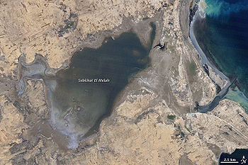
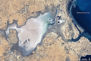 Sebkhat (or Sebkha) El Melah, Tunisia in 2001, mostly dry. Note rectangular industrial evaporite pans, probably for sea-salt production, upper right. Landsat 7 image.
Sabkha is a transliteration of the Arabic word for a salt flat. Sabkhas are supratidal, forming along arid coastlines and are characterized by evaporite-carbonate deposits with some siliciclastics. Sabkhas form subaerial, prograding and shoaling-upward sequences [1] that have an average thickness of a meter or less. The accepted type locality is along the coast of the Persian Gulf in the United Arab Emirates. This article outlines research into the evolution, hydrocarbon potential, climate, and dynamic nature of these deposits.
The origin and progression of sabkha development in the Persian Gulf is discussed by Al-Farraj (2005). In the khor-lagoon-sabkha model presented, an initial rise in sea-level floods coastal dune fields forming embayments between the dune crests. As the sediment is re-worked by the dominant winds and currents, spits, that parallel the shore, create a khor. A khor is a shallow, subtidal flat or tidal inlet in which grey mangroves may or may not grow depending on whether less saline water is available from wadis or groundwater. As sediment now begins to accumulate, these khors shallow and begin to form a lagoon, an intertidal flat. The lagoons continue to shallow until the lagoon floor is exposed at low tide. This is the beginning of sabkha development. An immature sabkha will be inundated during higher than normal spring tides, after rainstorms, or when driving winds push seawater onshore to a depth of a few centimeters. Mature sabkhas are only flooded after heavy rainstorms and eventually coalesce to form a sabkha coastal plain. These coastal plains are very flat, with reliefs between 10-50cm, and their seaward slope can be as little as 1:1,000.[2] The flatness of a sabkha is enhanced by aeolian siliciclastic dust being deposited in the topographic lows with most of the relief caused by evaporites.[3]
These environments can be found laterally contemporaneous in parallel belts to the coast as well. Coral reefs, barrier islands, and oolite shoals form the barrier with the open shelf.[4] These types of deposits are indicative of higher energy and protect the khor-lagoon environments, allowing for the growth of mangrove swamps and algal and cyano-bacterial mats that prefer the more closed, lower energy environment. Inland of this are the supratidal sabkhas. The sabkhas can be as wide as 15 km when seaward of dune fields supplying large amounts of sediment. Sabkhas seaward of low outcrops of Miocene carbonate-evaporites or alluvial fans off the Oman fold and thrust belt can be as narrow as several hundred meters.[5]
The climate is one of the main factors in sabkha development. Rainfall in this arid region usually occurs as thunderstorms and averages 4cm/year.[6] Temperatures can range in excess of 50°C to as low as 0°C. Humidity is linked to the wind direction, with humidity as low as 20% in the mornings from off the dry interior and building in the afternoon as a strong, onshore wind prevail. At night, relative humidity of 100% can lead to dense fogs.[3] Water temperatures vary by depth with shallow water as much as 10+°C warmer. These high temperatures drive high rates of evaporation in the Persian Gulf, as much as 124 cm/year[4] leading salinity to increase in the shallow lagoons to as much as 70ppt. The net rate of evaporation from the sabkha can be as much as an order of magnitude less and has averaged 6cm for the last 4,000 to 5,000 years.[3] The reasons for this are that the sabkha surface is not a free-water surface, the high humidity during the night, and vertical stratification of the air column. Despite the loss of water due to evaporation, the groundwater, never deeper than 1.5m, flows seawards and is recharged by continental waters, rainstorms, and the NW “shamal” gale-force winds that create waves of greater height than the intertidal height[5] and drive water as much as 5km inland over the sabkha to a depth of a few centimeters.
The climate variations lead to the very dynamic nature of a sabkha. Halite is deposited on the surface of the sabkha and gypsum and aragonite precipitate in the subsurface[2] via capillary action out of brines brought up from the water table.[7] In drier parts of the sabkha the gypsum can be altered to anhydrite and the aragonite can be dolomitized diagenetically.[8] Thermal contraction at night and expansion during the day leads to concave polygonal pans as the edges have been upturned,[4] in part due to growth of evaporites wedging the crack apart. Below this is a gypsum mush where nodules of anhydrite and other sulfates may develop. These might also form a “chicken wire” crystalline structure. Below this are the intertidal deposits typified by laminated, organic rich muds formed by the microbial mats that grade downward into more bioturbated muds. The subtidal facies show carbonate grainstones and lagoonal muds.
These facies sequences, except for the halite that is frequently re-dissolved when wetted, can easily be preserved. Factors enabling preservation include the progradation of the sabkha with sedimentation rates of 1m/1000 years and the creation of Stokes surfaces. These surfaces are created by the deflation of the sabkha surface that is related to the level of the groundwater table acting as a local base level.[9]
Sabkha deposits are believed to form some of the major subsurface hydrocarbon reservoirs in the Middle East (and elsewhere). The source of these hydrocarbons (both gas and oil) may be the microbial mats and mangrove paleosoils, found in the sabkha sequence, that have total organic carbon up to 8.2% and hydrogen indices typical of marine type II kerogens.[4]
Some ancient analogs include immediate subsurface formations such as the Permian Khuff, Jurassic Arab and Hith Anhydrite, and Tertiary sedimentary rocks. Similar deposits are also found in the Ordovician Williston Basin, the Permian Basin in Texas, as well as the Jurassic Gulf of Mexico. Modern sabkhas are present in varying form along the coasts of North Africa, Baja California, and at Shark Bay in Australia.
See also
- Sabkhat Matti
Sources
- Al-Farraj, A., 2005. An evolutionary model for sabkha development on the north coast of the UAE, Journal of Arid Environments, v. 63, p. 740
- Alsharhan, A.S., and Kendall, C.G.St.C., 2003. Holocene coastal carbonates and evaporites of the southern Persian Gulf and their ancient analogues, Earth-Science Reviews, v. 61, p. 191
- Butler, G.P., 1969. Modern evaporite eposition and geochemistry of coexisting brines, the sabkha, Trucial Coast, Arabian Gulf, Journal of Sedimentary Petrology, v. 39, no. 1, p. 70
- Lokier, S.W., and Steuber, T., 2007. Seasonal dynamics of a modern sabkha surface, Geophysical Research Abstracts, v. 9
- Patterson, R.J., and Kinsman, D.J.J., 1981. Hydrologic Framework of A Sabkha Along Arabian Gulf, AAPG Bulletin, v. 65, p. 1457
- Patterson, R.J., and Kinsman, D.J.J., 1982. Formation of Diagenetic Dolomite in Coastal Sabkha Along Arabian (Persian) Gulf, AAPG Bulletin, v. 66, no 1, p. 28
- Shanley, K.W., and McCabe, P.J., 1994. Perspectives on the Sequence Stratigraphy of Continental Strata, AAPG Bulletin, v. 78, no. 4, p. 544
- Warren, J.K, and Kendall, C.G. St. C., 1985. Comparison of Sequences Formed in Marine Sabkha (Subareal) and Salina (Subaqueous) Settings—Modern and Ancient, AAPG Bulletin, v. 69, no, 6, p. 1013
Notes
External links
- Sebkhat El Melah, Tunisia, from NASA's Earth Observatory
Categories:- Salt flats
- Geological processes
- Arabic words and phrases


Wikimedia Foundation. 2010.