- Cuenca, Ecuador
-
Cuenca — City — Santa Ana de Los Cuatro Ríos de Cuenca 

Flag
Coat of armsNickname(s): Atenas del Ecuador (Athens of Ecuador) Location in Ecuador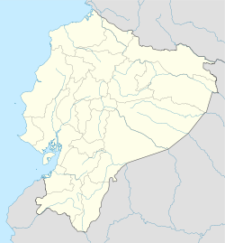
 Cuenca
Coordinates: 2°53′57″S 79°00′55″W / 2.89917°S 79.01528°WCoordinates: 2°53′57″S 79°00′55″W / 2.89917°S 79.01528°W Country Ecuador Province Azuay Canton Cuenca Canton Founded April 12, 1557 Founder Gil Ramírez Dávalos Named for Cuenca, Spain Parishes Urban Parishes- Bellavista
- Cañaribamba
- El Batán
- El Sagrario
- El Vecino
- Gil Ramírez Dávalos
- Hermano Miguel
- Huayna Cápac
- Machángara
- Monay
- San Blas
- San Sebastián
- Sucre
- Totoracocha
- Yanuncay
Government - Mayor Paúl Granda López Area - City 67.71 km2 (26.1 sq mi) Elevation 2,560 m (8,399 ft) Highest elevation 2,550 m (8,366 ft) Lowest elevation 2,350 m (7,710 ft) Population (2010)INEC census - City 330,000 - Density 4,873.7/km2 (12,622.9/sq mi) - Metro 505,632 The population total is of the urban parishes of the Municipality of Cuenca (the canton), which make up the city of Cuenca; the metro population is the population of the canton. Time zone ECT (UTC-5) Demonym Cuencanos Website Official website Cuenca (full name Santa Ana de los cuatro ríos de Cuenca) is the capital of the Azuay Province. It is located in the highlands of Ecuador at about 2500 m above sea level. The center of the city is listed as a UNESCO World Heritage Trust site because of its many historical buildings.
Contents
History
First inhabitants
According to studies and archeological discoveries, the origins of the first inhabitants go back to the year 8060 BC in the Cave of Chopsi. They were hunters, hunting everything the Páramo offered them, and nomadic, following the animals and seasons. The culture is represented by tools such as arrows and spears, which have been found throughout the Andean alley. The culture was most present about 5585 BC.
Later the early indigenous people used the stable climate, fertile soil and abundant water to develop agriculture. They grew potatoes, melloco, chocho, squash and quinoa. They also domesticated animals such as cuys, and camelids: llamas and alpacas.
Their technology also advanced; they started creating ceramics. These comprise the greatest number of artifacts which archeologists use to study their culture. The period from 5000 BCE to 2000 BCE is not represented well in the archeological record. Beginning around 2000 BCE, the people developed a more highly organized society, demonstrating delegated responsibilities, such as the managing of water and control of plagues. People specialized as administrative and religious authorities (known as shamans). This occurred during the periods of Chaullabamba, Huayco, Pirincay, Monjas, Putushio, Huancarcucho and Jubones. From then until 500 AD began the periods of Tacalshapa III and the Cañari people, who were absorbed into the Incas in the 15th century.
Pre-Columbian society
Cuenca was originally a Cañari settlement called Guapondeleg. It is believed to have been founded around 500 AD. Guapondeleg translates into "land as big as heaven." Less than half a century before the conquistadors landed, the Incas, after a bitter struggle, conquered the Cañari and occupied Guapondeleg and the surrounding area. Though the Incas replaced the Cañari architecture with their own, they did not suppress the Cañari or their impressive achievements in astronomy and agriculture. As was customary for the Incas, they absorbed useful achievements into their culture. They renamed the city Tomebamba. The city became known as the second Cusco, a regional capital.
After the defeat of the Cañari, the Inca commander, Tupac Yupanqui, ordered the construction of a grand city to be called Pumapungo, "the door of the Puma". Its magnificence was to challenge that of the Inca capital of Cuzco. Indians told stories to the Spanish chroniclers of golden temples and other such wonders, but by the time the Spaniards found the legendary city, all that remained were ruins. They wondered what happened to the fabled splendor and riches of the second Inca capital. After having been abandoned by the Cañari and then the Incas, Tomebamba was sparsely populated until the 1550s.
Tumebamba is considered a candidate for the mythical city of gold which the Spanish called El Dorado. The Spanish thought El Dorado was burned by the inhabitants after they heard of the Spanish conquests. Tomebamba's destruction by its inhabitants prior to the arrival of the Spanish suggests it may have been what the Spanish called El Dorado.
Spanish settlement
The Spanish settlement of Cuenca was founded on April 12, 1557 by the explorer Gil Ramírez Dávalos. Andrés Hurtado de Mendoza, then Viceroy of Peru had commissioned the founding and ordered the city named after his home town of Cuenca, Spain. It was founded decades after other major Spanish settlements in the region, such as Quito (1534), Guayaquil (1538), and Loja (1548).
Cuenca's population and importance grew steadily during the colonial era. It reached the peak of its importance in the first years of Ecuador's independence; Cuenca achieved its independence on November 3, 1820. It became the capital of one of the three provinces that made up the nascent republic. The other two capitals were Guayaquil and Quito.
Population
As per the last census, the population of the Cuenca canton was 500,632 inhabitants, of which 350,000 constitute the urban population (i.e., the population of the city proper). The economic development is based on industry and agricultural development.
Geography and location
Cuenca, capital of the province of Azuay, is located in the sierra of the Andes in the Austro or southern region of Ecuador. It is approximately nine hours south of Quito and four hours east of Guayaquil. The city ranges from 2,350 to 2,550 meters above sea level.
The dominant features of the city's geography are also the source of its name in Spanish: the four rivers of Cuenca (meaning a basin made by a confluence of rivers). These rivers are the Tomebamba (named after the Cañari culture), Yanuncay, Tarqui and Machangara, in order of importance. The first three of these rivers originate in the Páramo of Parque Nacional Cajas to the west of the city. These four rivers are part of the Amazon river watershed. Cuenca is surrounded by mountains on all sides, with passes to the west, south and east.
Parishes
Cuenca Canton contains the following parishes:
- Baños
- Chaucha
- Checa (Jidcay)
- Chiquintad
- Cuenca
- Cumbe
- Llacao
- Molleturo
- Nulti
- Octavio Cordero Palacios (Santa Rosa)
- Paccha
- Quingeo
- Ricaurte
- San Joaquín
- Santa Ana
- Sayausi
- Sidcay
- Sinincay
- Tarqui
- Turi
- Valle
- Victoria del Portete (Irquis)
Climate
Cuenca features a subtropical highland climate under the Köppen climate classification. Like the rest of the Ecuadorian Andes, Cuenca enjoys a mild climate year-round. Days are generally warm and nights are cool enough that sweaters or jackets are needed. The average daily temperature is 58 degrees Fahrenheit. There are two seasons: rainy and dry. The dry season, with some variation, falls between June and December. The rainy season, which is characterized by bright sunny mornings and afternoon showers, falls between January and May. The heaviest rains come in the invierno of March, April and May.
Climate data for Cuenca, Ecuador Month Jan Feb Mar Apr May Jun Jul Aug Sep Oct Nov Dec Year Record high °C (°F) 26.7
(80.1)26.1
(79.0)27.2
(81.0)24.4
(75.9)25.0
(77.0)25.0
(77.0)22.8
(73.0)25.6
(78.1)25.0
(77.0)27.2
(81.0)27.2
(81.0)27.2
(81.0)27.2
(81.0)Average high °C (°F) 20.6
(69.1)21.1
(70.0)20.6
(69.1)20.6
(69.1)19.4
(66.9)18.9
(66.0)18.3
(64.9)18.9
(66.0)20.6
(69.1)21.1
(70.0)21.7
(71.1)21.7
(71.1)20.3 Daily mean °C (°F) 15.3
(59.5)15.8
(60.4)15.6
(60.1)15.3
(59.5)14.4
(57.9)13.6
(56.5)13.3
(55.9)13.3
(55.9)14.7
(58.5)15.3
(59.5)14.7
(58.5)15.6
(60.1)14.7 Average low °C (°F) 10.0
(50.0)10.6
(51.1)10.6
(51.1)10.0
(50.0)9.4
(48.9)8.3
(46.9)8.3
(46.9)7.8
(46.0)8.9
(48.0)9.4
(48.9)7.8
(46.0)9.4
(48.9)9.2 Record low °C (°F) 3.3
(37.9)2.8
(37.0)3.9
(39.0)1.1
(34.0)0.0
(32.0)−0.6
(30.9)−1.7
(28.9)−1.1
(30.0)2.2
(36.0)−0.6
(30.9)−0.6
(30.9)1.1
(34.0)−1.7
(28.9)Rainfall mm (inches) 67
(2.64)85
(3.35)107
(4.21)109
(4.29)77
(3.03)68
(2.68)53
(2.09)47
(1.85)56
(2.2)73
(2.87)69
(2.72)67
(2.64)878
(34.57)Avg. rainy days (≥ 0.1 mm) 20 21 22 19 15 11 10 10 12 16 13 10 179 Sunshine hours 155 113 124 120 155 150 186 186 150 155 150 155 1,799 Source no. 1: Sistema de Clasificación Bioclimática Mundial (temperatures)[1] Source no. 2: Cuenca Climate Guide [2] Main sights
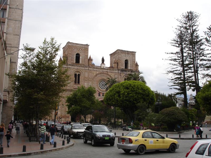
Historic Centre of Santa Ana de los Ríos de Cuenca * UNESCO World Heritage Site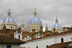
The Catedral NuevaCountry Ecuador Type Cultural Criteria ii, iv, v Reference 863 Region ** Latin America Inscription history Inscription 1999 (23rd Session) * Name as inscribed on World Heritage List
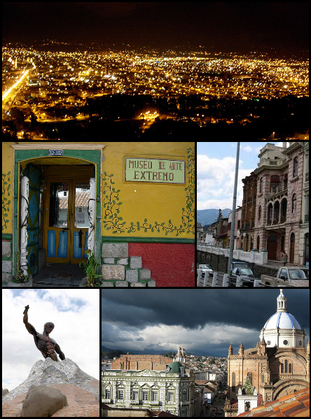
** Region as classified by UNESCOMost tourists visit the historic area, which is a UNESCO World Heritage Site, between the river Tomebamba and the street Gran Colombia to the north, General Torres to the west, and Hermano Miguel to the east. This area's compactness, grid-like layout, and numerous readily identifiable monuments make it easy to navigate. Outside this area the city can be confusing, as there are dozens of narrow colonial streets with similar buildings.
Major fiestas of Cuenca come at the time of the "Mass of Children" that is carried out the day of the Arrival of Kings (January 6 - Epiphany Day), or in the commemoration of the independence of the city (November 3), during which processions, cultural acts and dances are organized. The nearby Cañar plantation (in the county of the same name) features the biggest Inca ruins in Ecuador.
Landmarks
- Old Cathedral (Iglesia de El Sagrario). It was built in 1557, but soon was too small for the faithful of the town. In 1880, they decided to build a temple to replace it. At the present time, the old cathedral is in process of restoration. It is no longer consecrated and is operated as a museum.
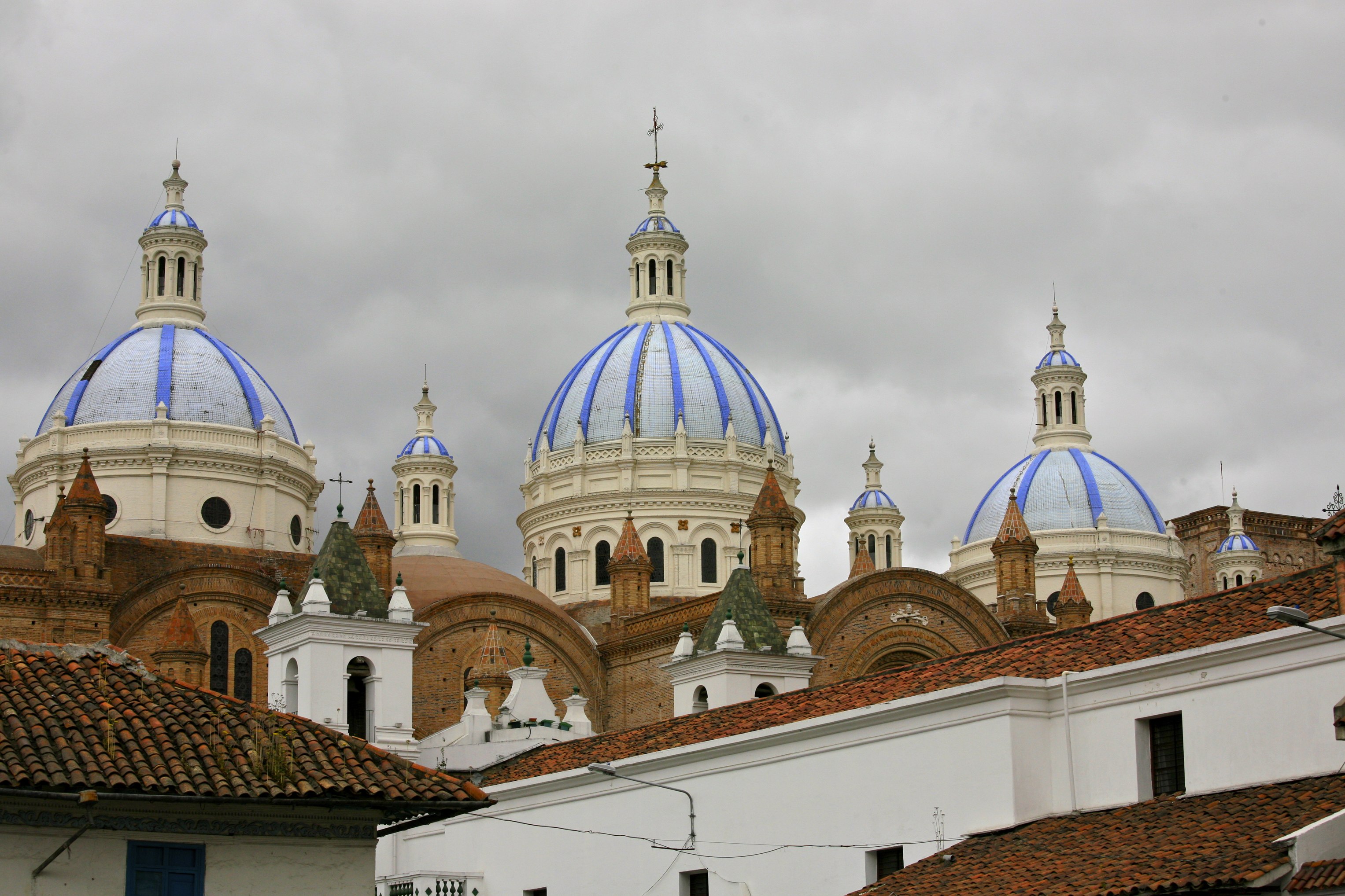
- New cathedral (official name: Catedral Metropolitana de la Inmaculada Concepción). Its towers are truncated due to a calculation error of the architect. If they had been raised to their planned height, the foundation of this church to the Immaculate Conception, would not have been able to bear the weight. In spite of the architect's immense mistake, the New Cathedral of Cuenca is a monumental work of faith that began to be built in 1880. It is in Neo-Gothic style, and its blue and white domes have become a symbol for the city. Its facade is made of alabaster and local marble, while the floor is covered with pink marble, brought from Carrara (Italy). When the Cathedral was first constructed 9,000 out of Cuenca's 10,000 inhabitants could fit in the building.
- Park Abdon Calderon. It is located in the center of Cuenca between the old and new cathedrals. On the park benches, people meet to converse and absorb its tranquility. The municipal offices are located nearby.
- Monastery of El Carmen de Asuncion. In the atrium a colorful flower market supplements the beauty of the church which was founded in 1682. A sculpted stone facade and a golden pulpit make the church very attractive.
- Monastery and Museum of La Concepcion, with 17th century tombs and a complete collection of religious art.
- House of the Ecuadorian Culture
- Municipal Museum Remigio Crespo Toral
- Museum of the Central Bank
- Museum of the Aboriginal Cultures
- Church of Santo Domingo
- San Blas.
- Ruinas de todos los santos. In this old place, four niches of Inca origin exist. Their form is trapezoidal and they are built of stone. There are also remains of a colonial mill.
 Cathedral of the Immaculate Conception.
Surroundings
- Molleturo, a vast rural area (about 1000 square kilometres) situated in Ecuador’s southern Andes, and composed of several little villages (hamlets). The centre of the area is located at 1.5 hours of distance in car from the nearest bigger city (Cuenca). In fact, this distance is very little compared to ten years ago when there was no road for cars and it took people 3 days of mule riding to get to Cuenca. In spite of the advantages, the road had also very negative impacts on the ecological system, which is still very important for people's daily survival.
- Jima, located near Cuenca and is a hiking hotspot for Southern Ecuador. Jima is located at the base of two beautiful green mountains at 8,800 feet. Hikes for all skill levels are available including a three day hike from the peaks of the Andes mountains down into the lush tropical rainforest of the Amazon basin.
- Gualaceo
- Chordeleg. Less than 50 kilometers from Cuenca, it is a town of Cañari origin, known for its weavers, embroiderers and potters. In the same area there is a stone corridor in snake form, built in pre-Inca time, known for gold and silver smiths and local jewelry.
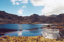
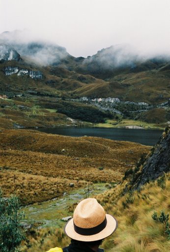
 View of Cajas National Park
- El Cajas, a national park where the rivers, streams and lagoons seem to unite, to create a temple of nature, in which the altitude varies from the 3500 to the 4200 meters above the sea level. It is a place for bird watchers and trout fishermen.
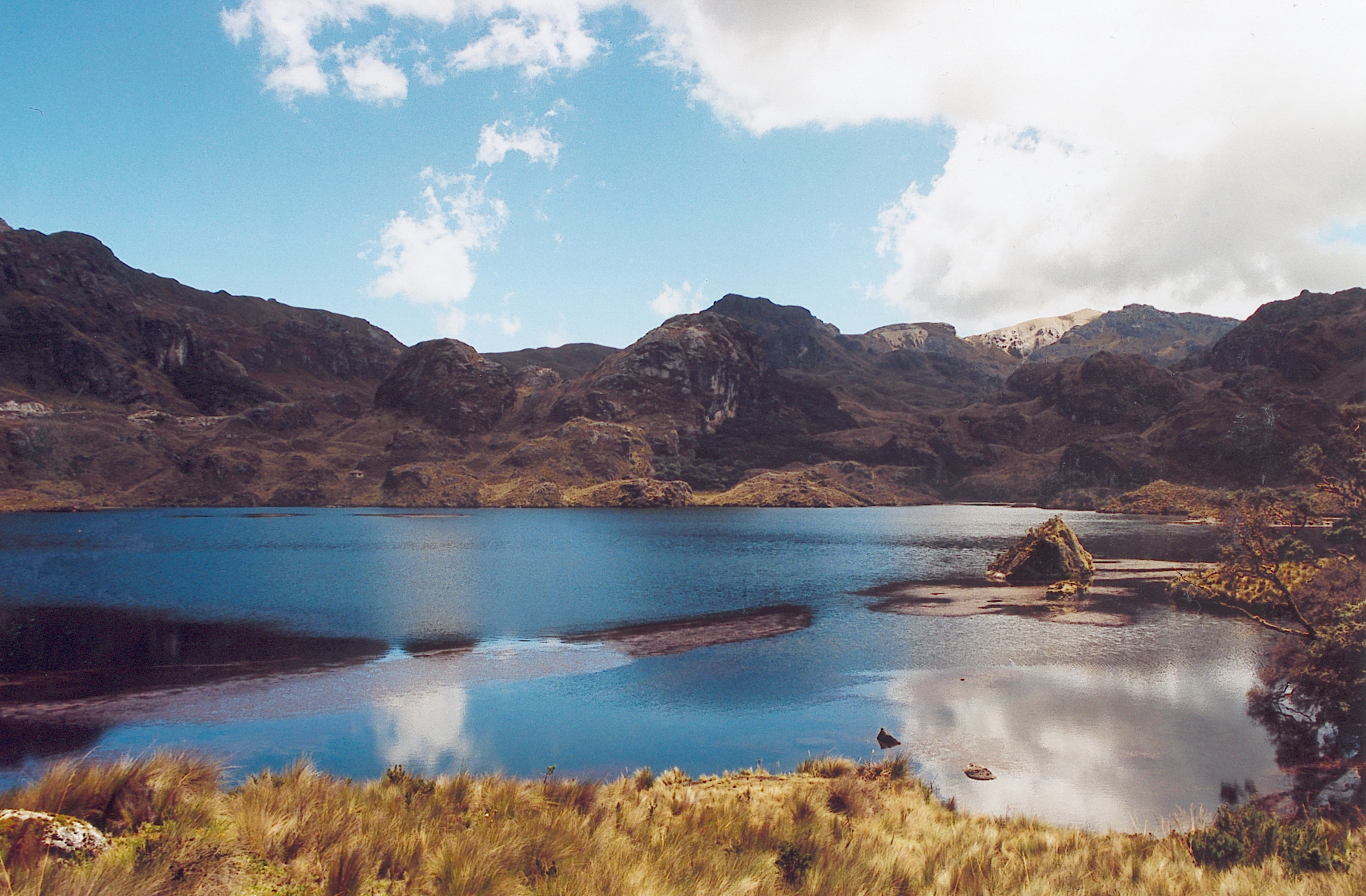
 Lacs en miroir (Mirrored lakes) in Cajas National Park
- Azogues, the capital of Cañar Province, 29 kilometers separate it from Cuenca. In this city of colonial atmosphere, one of the highlights is San Francisco's convent, built on the summit of a huaca (sacred mountain) of the prehispanic residents.
- Cañar plantation, with a coloring market and the near ruins of Ingapirca (wall of Inca stone). Cañar plantation is located 65 kilometers from Cuenca and it is usually the starting point for the trips to the famous ruins that, according to the experts, were used to control the native Cañaris. Stores, bathrooms, a tambo for the Inca, a temple dedicated to the sun, they are part of Ingapirca that was built in the XV century by orders of Huayna Capac.
Transport
Bus station
Cuenca's inter-provincial bus station, called the Terminal Terrestre as it is in most cities, is well organized and clean. It is located on Avenida España in the northeastern corner of the city, a twenty-minute walk or a brief taxi ride from the historic center. Also, many City buses provide frequent service as indicated by the "Terminal Terrestre" placard on the windshield. A guide to using the City buses, maps of the routes and an online trip planner can be found at CuencaTransit.com
Buses arrive and depart throughout the day. Service is available to major cities, such as Guayaquil and Quito and also to nearby cities such as Loja, Riobamba, or Machala. The distance to Guayaquil is 243 km. and the bus takes nearly 4 hours on the highway Durán-Pto.Inca-Molleturo, a scenic ride through the Cajas National Park. Quito is 497 km from Cuenca and the trip takes around 10 hours on the Road Pan-American South. Many prefer to travel by bus at night. Those who choose to travel overnight should exercise caution due to reported bus hijacks which have resulted in armed robbery.
Airport
The airport, named Aeropuerto Mariscal Lamar (Mariscal Lamar Airport), is located due east of the Terminal Terrestre (bus station) on Avenida España. It's a 5-minute walk from the bus station.Three airlines serve Cuenca in 2011; TAME and AeroGal fly to Quito and Guayaquil daily while LAN Ecuador only flies to Quito. RYU Peruvian airline Star Peru announced that it will begin flying to and from Chiclayo, Peru in November 2010; however operations have not started yet.
See also
References
- ^ "ECUADOR - CUENCA". http://www.ucm.es/info/cif/station/ec-cuenc.htm. Retrieved 3 November 2011.
- ^ "Cuenca CLimaet Guide, Ecuador". http://worldclimateguide.co.uk/climateguides/ecuador/cuenca.php. Retrieved 3 November 2011.
External links
- Official Travel Guide To Cuenca, with maps, hotels, restaurants, photos & more information about Cuenca
- A Guide to Using the City Buses in Cuenca
- Cuenca government
- Cuenca on Wikitravel
- Universidad del azuay
- Ecuador Special Events and Holiday Calendar
- Cultura, tradición y turismo de Cuenca - Ecuador
- Map of Cuenca
- Travel Map Guide To Cuenca, with maps, hotels, restaurants, maps & more about Cuenca
- Business Directory
- Gastronomic Guide
Provincial capitals in Ecuador Within regions, north to south Insular 
Costa Sierra Oriente  Cantons of Ecuador
Azuay Province Bolívar Province Cañar Province Carchi Province Chimborazo Province Cotopaxi Province El Oro Province Esmeraldas Province Galápagos Province Guayas Province Alfredo Baquerizo Moreno · Balao · Balzar · Colimes · Coronel Marcelino Maridueña · Daule · Durán · El Empalme · El Triunfo · General Antonio Elizalde · Guayaquil · Isidro Ayora · Lomas de Sargentillo · Milagro · Naranjal · Naranjito · Nobol · Palestina · Pedro Carbo · Playas · Salitre · Samborondón · Santa Lucía · Simón Bolívar · YaguachiImbabura Province Loja Province Calvas · Catamayo · Celica · Chaguarpamba · Espíndola · Gonzanamá · Loja · Macará · Olmedo · Paltas · Pindal · Puyango · Quilanga · Saraguro · Sozoranga · ZapotilloLos Ríos Province Manabí Province Bolívar · Chone · El Carmen · Flavio Alfaro · Jama · Jaramijó · Jipijapa · Junín · Manta · Montecristi · Olmedo · Paján · Pedernales · Pichincha · Portoviejo · Puerto López · Rocafuerte · San Vicente · Santa Ana · Sucre · Tosagua · Veinticuatro de MayoMorona Santiago Province Gualaquiza · Huamboya · Limón Indanza · Logroño · Morona · Pablo Sexto · Palora · San Juan Bosco · Santiago de Méndez · Sucúa · Taisha · TiwintzaNapo Province Archidona · Carlos Julio Arosemena Tola · El Chaco · Quijos · TenaOrellana Province Aguarico · Francisco de Orellana · Joya de los Sachas · LoretoPastaza Province Pichincha Province Santa Elena Province La Libertad · Salinas · Santa ElenaCategories:- Cuenca, Ecuador
- Populated places in Azuay Province
- Populated places established in 1557
- Province capitals in Ecuador
- World Heritage Sites in Ecuador


Wikimedia Foundation. 2010.