- Drakes Estero
-
Drakes Estero is an expansive estuary in Marin County on the Pacific coast of northern California in the United States, approximately 25 miles (40 km) northwest of San Francisco.
 Drakes Estero
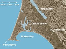
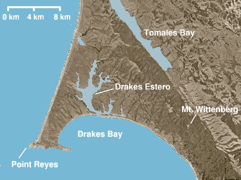
Located at 38°02′49″N 122°56′31″W / 38.047°N 122.942°W,[1] the estuary provides the main drainage for the Point Reyes peninsula. Seen from the air, Drakes Estero resembles a human hand, with Barries Bay, Creamery Bay, Schooner Bay, and Home Bay as the "fingers" and Limantour Bay as the thumb. The waters of the Estero flow into Drakes Bay between Drakes Beach and a narrow strip of land called Limantour Spit.
Drakes Estero is protected as part of the Point Reyes National Seashore and recognized for protection by the California Bays and Estuaries Policy.[2]
History
Drakes Estero is considered by many historians to be the most likely landing spot of Francis Drake on the coast of North America in 1579 during his circumnavigation of the world. The determination of the site, however, remains controversial. A historical marker has been placed on Drakes Beach near the Kenneth C. Patrick Visitor Center.
See also
- Abbotts Lagoon
- Bolinas Lagoon
- New Albion
- Tomales Bay
References
- ^ U.S. Geological Survey Geographic Names Information System: Drakes Estero
- ^ State Water Resources Control Board Water Quality Control Policy for the Enclosed Bays and Estuaries of California (1974) State of California
West Marin Villages Bolinas • Dillon Beach • Dogtown • Inverness • Inverness Park • Lagunitas • Marshall • Millerton • Muir Beach • Nicasio • Olema • Pt. Reyes Station • Stinson Beach • TomalesGeography Audubon Canyon • Bolinas Lagoon • Bolinas Ridge • Bonita Channel • Centissima Reef • Copper Mine Gulch • Drakes Bay • Drakes Estero • Gull Rock • Pirates Cove • Point Reyes • Kent Island • Nicasio Creek • Nicasio Reservoir • Olema Valley • Rancho Punta de los Reyes Sobrante • Rodeo Lagoon • Rodeo Cove • Tennessee Cove • Tomales Bay • Sears RockParks and transportation Categories:- West Marin
- Marin County, California geography stubs
- Estuaries of California
- Lagoons of California
- Landforms of Marin County, California
- Wetlands of the San Francisco Bay Area
Wikimedia Foundation. 2010.