- New Albion
-
This article is about the area claimed by Francis Drake on the Pacific coast of North America. For the region named by Sir Edmund Plowden, see New Albion (colony). For the town in western New York, see New Albion, New York.

New Albion, also known as Nova Albion, was the name of the region of the Pacific coast of North America explored by Sir Francis Drake and claimed by him for England in 1579. The extent of New Albion and the location of Drake's landing have long been debated by historians, with most believing that he came ashore somewhere on the coast of northern California.
Albion, "the white", is an archaic name for the island of Great Britain—a reference to the chalk cliffs lining the English Channel in Kent.
Contents
History
During his circumnavigation of the globe (1577–1580), in which he was ordered to destroy the Spanish flotillas in the New World and plunder settlements, Sir Francis Drake landed on the western coast of North America and claimed the area for Queen Elizabeth I as New Albion. Along with Martin Frobisher's claims in Greenland and Baffin Island and Drake's claims at the tip of South America, New Albion was one of the earliest English territorial claims in the New World. However, unlike Humphrey Gilbert's 1583 claim of Newfoundland, it was not followed up by settlements.[1]
Assertions that he left some of his men behind as an embryo "colony" are founded merely on the reduced number who were with him in the Moluccas.[2]
The western coast of North America had been partially explored in 1542 by Juan Rodriguez Cabrillo who sailed for the Spanish, but as England was in conflict with Spain, Drake decided to claim the region. Wherever his actual landing place was, it was well north of San Diego Bay where Cabrillo had asserted Spain's claim. Spain had claimed the entire Pacific coast of the Americas since the Inter caetera papal bull of 1493, reinforced in 1513 when Vasco Núñez de Balboa formally claimed all lands adjoining the Pacific Ocean for the Spanish Crown. However, England did not recognize the authority of the Inter caetera and Balboa's claim covered a vast and mostly unknown area.
Upon his return to England on 4 April 1581, Francis Drake was knighted by the French Ambassador on behalf of Queen Elizabeth I for his deeds against the Spanish during the circumnavigational voyage. However, in order to keep an uneasy peace with Spain, and to avoid having Spain threaten England's other claims in the New World, Drake's logs, charts, and other writings were confiscated. Thus, the discovery and claim on New Albion was ordered by the Queen to be considered a state secret. Drake and his crew were sworn to silence on pain of death. Only years later, after England's destruction of the Spanish Armada in 1588 (in which Drake played a significant role), did Queen Elizabeth allow an official account of Drake's voyage by Richard Hakluyt to be published — though with many of the details obscured.
However, Drake was always uneasy with the misrepresentations in the "official" account, and in 1592, he wrote to Queen Elizabeth in reference to "the certain truth concealed, as I have thought it necessary myself." and requesting that the account be rewritten accordingly. The Queen denied his request.
Drake's account of the voyage including many details of New Albion was published in 1628.[3]

After Elizabeth's death, maps began to mark the area of North America above New Spain and New Mexico as Nova Albion, although the boundaries and locations greatly differ among maps. However, Drake's claiming land on the Pacific coast became the legal basis for subsequent colonial charters granted by English monarchs that claimed lands from "sea to sea" (i.e. from the Atlantic where English colonies were first settled, to the Pacific). However, despite these claims, the English did not establish a colonizing presence on the west coast of North America until the late 18th century in the form of the explorations and asserted claims of Captains Cook and Vancouver and the associated Nootka Conventions, shortly after, the establishment of the Columbia Fur District of the Hudson's Bay Company and its headquarters at Fort Vancouver.
Location
Despite universal agreement among historians that Drake landed on the west coast of North America, the exact location of New Albion has been the subject of several theories: the only confirmed sixteenth-century archaeological evidence being pieces of porcelain found at Drakes Bay.[4]
Most prevalent theory
Drake's Cove, Drakes Bay, California
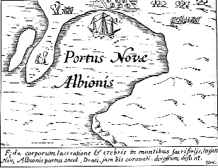
 Jodocus Hondius c. 1595 map detail of New Albion compared to Drake's Cove, Drakes Bay, California 1579
 Drakes Bay
The most prevalent theory has been that Drake landed in Marin County, California, near Point Reyes, just north of the Golden Gate.38°02′03″N 122°56′27″W / 38.034223°N 122.940800°W
Starting in the seventeenth century, maps identify Drakes Bay as Drake’s landing site.
George Vancouver studied Drake’s landing site and concluded it was in Drakes Bay.
"Professor George Davidson, of the United States Coast and Geodetic Survey, after a careful study of the narrative and the coast identifies the harbour entered by Drake with Drake's Bay, under Point Reyes, about thirty miles (50 km) north of San Francisco. 'Drake's Bay,' he says, 'is a capital harbor in northwest winds, such as Drake encountered. It is easily entered, sheltered bv high lands, and a vessel may anchor in three fathoms, close under the shore in good holding ground.'"[5]
Since 1949, the theory that Drake landed at Drakes Bay has been advocated by the Drake Navigators Guild in California, and notably by its former president Captain Adolph S. Oko, its former honorary chairman Chester W. Nimitz, and its longtime former president Raymond Aker. Oko wrote, "Many other correlative facts have been ... found true to the Drake's Cove site as part of the total body of evidence. The weight of evidence truly establishes Drake's Cove as the nodal point of Nova Albion."[6] Nimitz stated that he did "not doubt that in time the public will come to recognize the importance and value of this long-lost site (Drake's Cove in Drakes Bay), and will rank it with other National Historic Sites such as Roanoke, Jamestown, and Plymouth."[7]
Aker made detailed studies reconstructing Drake's circumnavigation voyage. Advocates of this theory cite the fact that the official published account placed the colony at 38 degrees north. The geography of Drake's Cove, which lies along the coast of Marin County, has often been suggested as being similar to the cove described by Drake, including the white cliffs that look like the south coast of England and the specific configuration of the Cove. The current geographical fit is by no means complete, however, leaving open the question, even among those who support the Marin County theory, as to the location of the colony. Aker maintained that the criticisms of the cove's geography were unfounded, because the configuration of the sandbars in the cove was cyclic over the decades. He predicted that a spit of land which closely resembles one on the Hondius map that disappeared in 1956 would reappear: it formed again in 2001.[8]
Nearly one hundred pieces of sixteenth-century Chinese porcelains have been found in the vicinity of the Drake's Cove site which “must fairly be attributed to Francis Drake’s Golden Hind visit of 1579.”[9]
Proximate to Drake's Bay is the Coast Miwok village site of Olompali (historically spelled "Olompolli"). According to the Olompali Park website, a pierced Elizabethan silver sixpence bearing the date of 1567--the oldest artifact bearing a calendar date ever found in California--was discovered in the park by archeologists. This indicates that Olompali residents may have had contact with Sir Francis Drake or with people who had traded with the English explorer. The sixpence is now in the collection of the Bancroft Library, University of California at Berkeley, CA.
Other theories
Sixteen other locations have been advanced as the site of Drake's port.[10] Davidson recognized a plethora of confusion from chiefly armchair historians including Samuel Johnson[11] and Jules Verne.[12][13]
Point San Quentin, San Francisco Bay, California
Robert H. Power (1926–1991), co-owner of the Nut Tree in Vacaville, CA, promoted the idea that Drake’s New Albion was inside San Francisco Bay near Point San Quentin.37°56′22″N 122°29′12″W / 37.939400°N 122.486700°W Among his arguments was that the Hondius Broadside map matched a part of the topography when parts were adjusted using a 2:1 correction.[14] Among the problems with Power’s idea is the difficulty of sailors finding San Francisco Bay from the ocean (it was first discovered by land and the first sea attempts to then locate the Bay failed), the lack of continuous foggy weather, the multitudes of good harbors, and the extreme dangers of entering such a bay on an unknown basis.
Tomales Bay, California
Historian Robert Becker found a location to which the Hondius Broadside map could apply at Tom’s Point on the east side of Tomales Bay.38°10′15″N 122°54′46″W / 38.170798°N 122.912781°W[15]
Whale Cove, Oregon
In 1978 British amateur historian Bob Ward, after making an exhaustive study of the geography of the Pacific coast of the U.S. and Canada, suggested that Drake actually landed much farther north, in Whale Cove in present-day Oregon.44°47′20″N 124°04′14″W / 44.788944°N 124.070689°W Advocates of the Whale Cove theory argue that when Captain James Cook first sighted the American coast at Cape Foulweather two centuries later, he described it in his log, with unknowing accuracy, as "the long-looked for coast of New Albion." Whale Cove lies just north of Cape Foulweather. Advocates of the Whale Cove theory dismiss the latitude given by Drake on the grounds that he may have deliberately falsified it in order to deceive the rival Spanish. Although the official account of Drake's voyage gives the anchorage location as 38 degrees, the only two known hand-written accounts of the voyage, preserved in the British Library, say that it was at 44 degrees, which is on the mid-Oregon coast. Drake and Queen Elizabeth, they argue, falsified the location because he mistakenly thought he had discovered the North West Passage when he found, and sailed into, the Strait of Juan de Fuca, which today separates Vancouver Island, British Columbia from the mainland Olympic Peninsula of Washington state.[citation needed]
Nehalem Bay, Oregon

Garry Gitzen suggested that Drake landed at Nehalem Bay, Oregon.45°41′11″N 123°55′58″W / 45.686430°N 123.932860°W (See Overlay Map of Nehalem Bay)[16]
Gitzen claims the “Neahkahnie Mountain Survey,” the Hondius Map, the Nehalem Indians and the Three Arch Rocks prove Drake’s landing site was in Nehalem Bay Oregon.
Gitzen argues that the “Survey” is a formal survey of the coastal area two to four miles north of Nehalem Bay encompassing the area up to one mile inland. The rocks include the “AUGUR” rock which includes “Roman numbers, Latin italics, and some, although they looked like Roman capital letters, were actually angles and bearings,” the “W” rock which has components that “represent a combination of sun and star sighting points to determine the longitude, date and time and day,” and the “Rays Rock” which “is a compass rose point used to measure points on Neahkahnie Mountain and beyond.”
Gitzen claims the outline and topography of Nehalem Bay match the Hondius Map, and that the Islands of Saint James are the Three Arch Rocks 13 miles south of the entrance to Nehalem Bay.
Gitzen does not explain why Drake would have executed this single formal survey of his voyage, and why such an extensive survey would not be in any of the thorough documentation of the visit. He claims the survey is from Drake, but does not prove the rock markings show what they are stated to contain and does not prove the age of the markings. Nehalem Bay does not match the Hondius Map’s island, peninsula shape and other characteristics. The Hondius Map indicates a bay several ship-lengths across, while Nehalem Bay is more than one mile across. While a number of Native American characteristics are common on the Pacific Coast, Gitzen does not explain why fully feathered baskets known only among the Coast Miwok of California are described in the accounts.[17] Three Arch Rocks are small, each at three to four acres in size, located just offshore where they have long been recognized as “rocks,” not “islands:” the Farallon Islands, in contrast, comprise 211 acres 27 miles (43 km) offshore.
Vancouver Island, British Columbia, Canada
In 2003 Canadian R. Samuel Bawlf suggested[18] that Drake's New Albion was Vancouver Island and that Drake erected a post containing such a proclamation at what is today Comox, British Columbia, located on Vancouver Island.49°40′N 124°57′W / 49.66°N 124.95°W Bawlf points to a number of pieces of evidence in support of his view that the official published record of Drake's voyage was deliberately altered to suppress the true extent of his discoveries. Bawlf also relies heavily upon the configuration of the coastline as depicted in some of the maps and globes of the era, including the so-called French and Dutch Drake Maps which depict his voyage as having reached a point northward of a chain of islands to the northwest of New Spain and other maps depicting New Albion at latitudes above those of northern California, such as Richard Hakluyt's 1587 map of the New World showing Nova Albion at 50 degrees north latitude. Bawlf also placed emphasis on the fact that on an initial rendition of his globe in 1592 Emery Molyneux depicted the line of the coast of North America behind Vancouver Island with remarkable accuracy, although the islands themselves, depicted on the French and Dutch Drake maps, do not appear.
Although Bob Ward initially drew some of the discrepancies between the official published accounts of Drake's voyage and other documents to Bawlf's attention, and concluded that Drake likely sailed much farther to the north than northern California, he has been critical of some of Bawlf's conclusions, such as Drake's erecting a post proclaiming New Albion at what is now Comox Bay.
Bawlf's work has also been criticized by Edward Von der Porten, President of the Drake Navigators Guild. Von der Porten calculates that Bawlf's theory requires the Golden Hinde to have traveled "an average of 5.95 knots... in a ship capable of less than one knot in those conditions." Further, Bawlf fails to identify the white cliffs, the Islands of St. James or the Coast Miwok People. Von der Porten states that Bawlf "has no evidence for either the conspiracy or his 'ten degree rule.'"[19]
Francis Pretty's account of Drake's landing
The following is an excerpt of an account by Francis Pretty[20]:
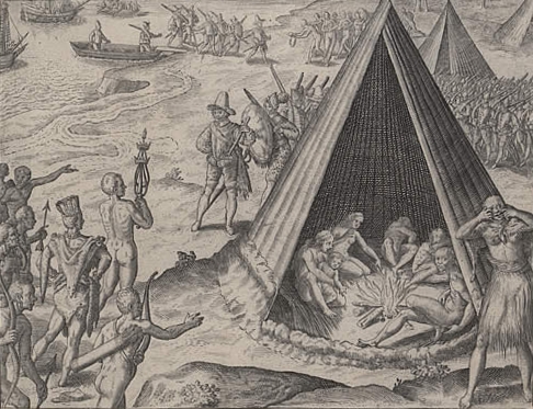
Our necessary business being ended, our General with his company travelled up into the country to their villages, where we found herds of deer by a thousand in a company, being most large, and fat of body. We found the whole country to be a warren of a strange kind of coneys; their bodies in bigness as be the Barbary coneys, their heads as the heads of ours, the feet of a want [mole], and the tail of a rat, being of great length. Under her chin is on either side a bag, into the which she gathereth her meat, when she hath filled her belly abroad. The people eat their bodies, and make great account of their skins, for their king's coat was made of them. Our General called this country Nova Albion, and that for two causes; the one in respect of the white banks and cliffs, which lie towards the sea, and the other, because it might have some affinity with our country in name, which sometime was so called. There is no part of earth here to be taken up, wherein there is not some probable show of gold or silver.At our departure hence our General set up a monument of our being there, as also of her Majesty's right and title to the same; namely a plate, nailed upon a fair great post, whereupon was engraved her Majesty's name, the day and year of our arrival there, with the free giving up of the province and people into her Majesty's hands, together with her Highness' picture and arms, in a piece of six pence of current English money, under the plate, whereunder was also written the name of our General.
It seemeth that the Spaniards hitherto had never been in this part of the country, neither did ever discover the land by many degrees to the southwards of this place.—[21]Pretty's description of some of the animals in the area as looking like strange kind of Conies with the tail of a Rat, being of great length lead to its identification as the Botta Pocket Gopher (Thomoys bottae bottae).[22] The description of the Botta Pocket Gopher is important because it is known at the Drakes Bay site.
False reports and hoaxes
For nearly four decades after the so-called "Drake's Plate of Brass" came to public attention in 1936, it was believed that the "plate" that Pretty describes had been found. The so-called "Drake's Plate" was revealed to be a practical joke among local historians that got out of control and became a full-blown public hoax.
Legacy
The community of Albion, British Columbia, now part of the District of Maple Ridge and just across the river from Fort Langley, was named to celebrate the idea that Drake had explored that far north and that British Columbia was, as British colonists would have liked to believe or confirm, the area of Nova Albion.
See also
- New England
- History of the west coast of North America
- Drake's Plate of Brass
- Anglican Church of Canada
Related links
References
Footnotes
- ^ Sugden, John (1990). Sir Francis Drake. Barrie & Jenkins. p. 118. ISBN 0712620389.
- ^ Dismissed by John Cummins, Francis Drake: The Lives of a Hero 1997:118: "In view of the prominence given in different versions to the crowning of Drake it would be odd if the establishment of a colony had gone unrecorded."
- ^ The World Encompassed by Sir Francis Drake, being his next voyage to that to Nombre de Dios formerly imprinted, 1628
- ^ Shangraw, Clarence; Von der Porten, Edward (1981). THE DRAKE AND CERMEÑO EXPEDITIONS' CHINESE PORCELAINS AT DRAKES BAY, CALIFORNIA 1579 AND 1595.
- ^ Brereton, Robert Maitland, C.E., Did Sir Francis Drake Land on Any Part of the Oregon Coast?, J. K. Gill Company, Portland, Oregon, 1907
- ^ Oko, Captain Adolph S., Francis Drake and Nova Albion, California Historical Society Quarterly, Vol. XLIII, No. 2, June 1964
- ^ Nimitz, Chester W., Drake's Cove, Pacific Discovery, California Academy of Sciences, Vol. 11, No. 2, 1958.
- ^ Again a safe harbor: Tiny cove many believe Sir Francis Drake repaired to 422 years ago suddenly reappears,San Francisco Chronicle, July 18, 2001.[1]
- ^ Shangraw, Clarence; Von der Porten, Edward (1981). THE DRAKE AND CERMEÑO EXPEDITIONS' CHINESE PORCELAINS AT DRAKES BAY, CALIFORNIA 1579 AND 1595.
- ^ San Francisco Chronicle: Again a safe harbor / Tiny cove many believe Sir Francis Drake repaired to 422 years ago suddenly reappears: July 18, 2001: Nolte, Carl
- ^ Johnson, Samuel (1767). The life of Mr. Richard Savage, son of the Earl Rivers; to which are added the lives of Sir Francis Drake and Admiral Blake (3rd ed.).
- ^ Oko, Captain Adolph S., Francis Drake and Nova Albion, California Historical Society Quarterly, Vol. XLIII, No. 2, June 1964, pp. 6-7
- ^ Verne, Jules, Great Voyages and Great Navigators, Part II, No. 466, Vol. XXIV, George Munro publisher, 1879, p. 33
- ^ Power, Robert (1974). Francis Drake & San Francisco Bay: a Beginning of the British Empire. University of California, Davis.
- ^ Gilliam, Harold; Hyde, Philip (1973). Island in Time, The Point Reyes Peninsula, revised second edition. Sierra Club / Scribner Library. pp. 14. ISBN 684-13439-X.
- ^ Gitzen, Garry (2008). Francis Drake in Nehalem Bay 1579, Setting the Historical Record Straight. Garry D. Gitzen. ISBN 0-578-00625-1.
- ^ The World Encompassed by Sir Francis Drake, being his next voyage to that to Nombre de Dios formerly imprinted, 1628
- ^ Bawlf, R. Samuel (2003). The Secret Voyage of Sir Francis Drake, 1577-1580. Douglas & McIntyre. ISBN 1-55054-977-4.
- ^ Von der Porten, Edward, A New Drake Myth,Sea History, National Maritime Historical Society, No. 106, Winter 2004, pp. 10-12.
- ^ The original English version of Richard Hakluyt's Famous Voyage in 1589 does not reference any specific author. The Hakluyt Society reports that Hakluyt's second edition credits Pretty for the account of Thomas Cavendish's voyage. An early French version of Famous Voyage ascribes the Drake Account to Pretty. Since then, this mis-attribution has been widely reprinted.
- ^ Modern History Sourcebook: Francis Pretty: Sir Francis Drake's Famous Voyage Round the World, 1580
- ^ Allen, Robert; Parkinson, Robert (1971). Identification of the Nova Albion Coney. Drake Navigators Guild.
Categories:- British colonization of the Americas
- Pre-state history of California
- Exploration of North America
- Pre-state history of Oregon


Wikimedia Foundation. 2010.