- Tittmoning
-
Tittmoning 

 TittmoningLocation of the town of Tittmoning within Traunstein district
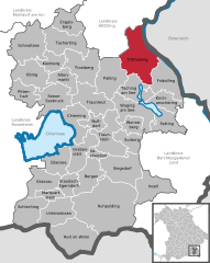
Coordinates 48°3′47″N 12°46′1″E / 48.06306°N 12.76694°ECoordinates: 48°3′47″N 12°46′1″E / 48.06306°N 12.76694°E Administration Country Germany State Bavaria Admin. region Upper Bavaria District Traunstein Mayor Konrad Schupfner (CSU) Basic statistics Area 72.04 km2 (27.81 sq mi) Elevation 388 m (1273 ft) Population 6,009 (31 December 2010)[1] - Density 83 /km2 (216 /sq mi) Other information Time zone CET/CEST (UTC+1/+2) Licence plate TS Postal code 84529 Area code 08683 Website www.tittmoning.de Tittmoning is a town in the district of Traunstein, in Bavaria, Germany. It is situated on the border with Austria, on the left bank of the river Salzach, 38 km northwest of Salzburg. Population 6,151 (30 June 2005). Postal code 84529.
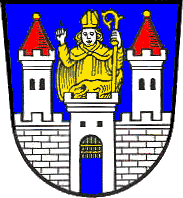
Its main attraction is the castle (Burg), which was built in the 13th century for the Archbishop of Salzburg. By the 17th century it had lost its character of a defensive castle and became the summer residence of the Archbishop. In the early years of World War II the castle was used as a prisoner-of-war camp for officers, Oflag VII-D.
From 11 July 1929 to 5 December 1932, Joseph Ratzinger lived here as a child. Later he became a cardinal and in 2005 was elected Pope Benedict XVI.
A festival takes place here every year at the end of May, with theatrical presentations, medieval tournaments and jousting.
Altenmarkt an der Alz | Bergen | Chieming | Engelsberg | Fridolfing | Grabenstätt | Grassau | Inzell | Kienberg | Kirchanschöring | Marquartstein | Nußdorf | Obing | Palling | Petting | Pittenhart | Reit im Winkl | Ruhpolding | Schleching | Schnaitsee | Seeon-Seebruck | Siegsdorf | Staudach-Egerndach | Surberg | Tacherting | Taching am See | Tittmoning | Traunreut | Traunstein | Trostberg | Übersee | Unterwössen | Vachendorf | Waging am See | Wonneberg
References
- ^ "Fortschreibung des Bevölkerungsstandes" (in German). Bayerisches Landesamt für Statistik und Datenverarbeitung. 31 December 2010. https://www.statistikdaten.bayern.de/genesis/online?language=de&sequenz=tabelleErgebnis&selectionname=12411-009r&sachmerkmal=QUASTI&sachschluessel=SQUART04&startjahr=2010&endjahr=2010.
Categories:- Towns in Bavaria
- Castles in Bavaria
- Traunstein district
- Upper Bavaria geography stubs


Wikimedia Foundation. 2010.