- Obing
-
Obing 

 ObingLocation of Obing within Traunstein district
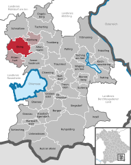
Coordinates 48°0′N 12°25′E / 48°N 12.41667°ECoordinates: 48°0′N 12°25′E / 48°N 12.41667°E Administration Country Germany State Bavaria Admin. region Upper Bavaria District Traunstein Municipal assoc. Obing Local subdivisions 60 Ortsteile Mayor Hans Thurner Basic statistics Area 43.75 km2 (16.89 sq mi) Elevation 562 m (1844 ft) Population 3,978 (31 December 2010)[1] - Density 91 /km2 (235 /sq mi) Other information Time zone CET/CEST (UTC+1/+2) Licence plate TS Postal code 83119 Area code 08624 Website www.obing.de Obing is a municipality in the district of Traunstein in Bavaria, Germany.
Altenmarkt an der Alz | Bergen | Chieming | Engelsberg | Fridolfing | Grabenstätt | Grassau | Inzell | Kienberg | Kirchanschöring | Marquartstein | Nußdorf | Obing | Palling | Petting | Pittenhart | Reit im Winkl | Ruhpolding | Schleching | Schnaitsee | Seeon-Seebruck | Siegsdorf | Staudach-Egerndach | Surberg | Tacherting | Taching am See | Tittmoning | Traunreut | Traunstein | Trostberg | Übersee | Unterwössen | Vachendorf | Waging am See | Wonneberg
References
- ^ "Fortschreibung des Bevölkerungsstandes" (in German). Bayerisches Landesamt für Statistik und Datenverarbeitung. 31 December 2010. https://www.statistikdaten.bayern.de/genesis/online?language=de&sequenz=tabelleErgebnis&selectionname=12411-009r&sachmerkmal=QUASTI&sachschluessel=SQUART04&startjahr=2010&endjahr=2010.
Categories:- Municipalities in Bavaria
- Traunstein district
- Upper Bavaria geography stubs


Wikimedia Foundation. 2010.